Friday, February 14, 2014

A Partial History of the Eastern Siouans


A Partial History of the Eastern Siouan People
I am indebted to so many people who have helped me with this research project. The people at the www.saponitown.com/forum were very helpful. Without their help I would never have even started researching the Eastern Siouan Peoples. Despite their words, I always remained skeptical. I will always believe that to find the truth you HAVE TO BE skeptical of everything.  Dr. Thomas Blumer made me believe that I really might be part Catawba. Forest Hazel's research was of great help. Dr. Richard Allen Carlson's research proved the Melungeons were of Saponi ancestry. And there are so many others to whom I want to say thank you, too many to name. Even people I have argued with constantly, have been a great help. I thank you all.

Please know to look at the maps just click on them, and they will get larger.

Map 1.


The map above (map 1) was taken from page 7 of “The Juan Pardo Expeditions”, by Charles Hudson, University of Alabama Press, (c) 1990, originally published by the Smithsonian Institution Press.

Please notice the location of Chicora. On the previous page (6), Hudson says: . . . another colonial venture was set in potion in 1521 when two ships dropped anchor off the Atlantic coast of the Lower South. One of these ships was owned by Lucas Vasquez de Ayllon, an official of Santo Domingo. The Spaniards went ashore, where they had a friendly encounter with the Indians, some of whom they persuaded to come out and visit their ships. But when the Indians canoed out and climbed aboard, the Spaniards promptly enslaved about sixty of them and sailed for Santo Domingo (Frances Lopez de Gomara, Historia general de los Indias, Madrid, 1932, vol. 1, pp. 89-90, translated in New American World: A Documentary History of North America to 1612, ed. David B. Quinn, New York, : Arno Press, 1979, vol. 1, p. 248.). One of the ships sank en route, and most of the Indians on the other ships died, but at least one of the Indians on the other ships survived, to be baptized Francisco de Chicora. (Peter Martyr, De Orbe Novo, ed. And trans. F. A. MacNutt (New York, 1912, vol. 2, pp. 254-271.).

Francisco later was taught Spanish, and returned to the Carolina coast with a future expedition to colonize the lands for the Spanish. Of course he escaped, went home, and there is no further mention of the Chicora. But we do have a band of Eastern Siouan called the Shakora. Are these the same as Chicora? Perhaps the Chicora fled the coast after the Spanish enslaved some of their warriors, feeling it was safer in the interior.

From viewing map 6, it appears they fled upstream 150 or 200 miles, where they are called Shakori by 1650. By 1700, per map 7, they are in relatively the same location still called Shakori. We will hear more about them later.
Map 2.


Above is a map from 'The Juan Pardo Expedition, Hudson, page 24. It shows the route taken by De Soto, earlier. East and North of the line from Hymahi to Cofitachequi to Xuala to Guasili, we have the Eastern Siouan peoples. To the west of Cofaqui in the south to Chiaha to the north, we have the Muscogeean speaking peoples. The Cherokees will enter later and conquer the northern parts of the Creek (Muscogeean) territory, from Chiaha to Coosa. The word 'Coosa' is of Creek origin – these communities either are not Cherokee, or non-Cherokees provided the names of these communities.

There are some interesting Eastern Siouan towns mentioned by both De Soto and Pardo. We have Xuala, the origin of the Saura, and Cofitachiqui, a town that awed the Spaniards. What the Spaniards called Xuala and later Joara on the map of the Juan Pardo expedition below, turns out to be one of the main bands of the Eastern Siouan tribes, and is later called Saura/Cheraw. The Guaquiri/Guateree later move nearer the Catawba and become known as Wateree.
Map 3.


Above map, from The Juan Pardo Expedition, Hudson, page 24. It shows the route of his expedition. The line from Juara to Olamico. The 'mico' ending indicates a Muscogeean (Creek) origin to the name. Joara of Pardo's (1566-1567) expedition is the equivalent of Xuala from De Soto's (1539-1540) day. The English called these people Saura, which later became Cheraw. Pardo only went as far as just beyond Juara. Moyano made the advance further to the northwest, to Olamico.

Map 7 shows the Cheraw's/Saura's on the Upper Dan about 1700. Unfortunately, they are not shown on map 6, dated about 1650. Map 8 shows some of the Indian movements Tuscarora War, It shows the Saura/Cheraw south and east of the main Catawba cities. They had left their cities on the Dan River in 1703.

Map 4.

Below is another map found in 'The Expeditions of Juan Pardo, Hudson'. Many towns listed are from the Spanish era, but the rivers were named later. The caption to the map below is self explanatory. The towns on the far western and far southern parts of the above map are Creek/Muscogeean in origin. Something to ponder – most of both the Siouan and Muscogeean towns the Spaniards listed had disappeared before English chroniclers rediscovered them. What had happened to them? Be thinking about that.

Guatari is also of interest. In Spanish, 'Gua' is pronounced as the English 'wa', and the Spanish 'i' is pronounced like the English long 'e'. So Guateri should be pronounced 'Wa-ta-ree'. Map 13 also shows the movements of the Guateree/Wateree from/to 1670 when they flee to live near the Catawba,where they remained until they vanished.

Also notice the towns of Yssa and Yssa the lesser. This is identical to Esaw, Issa, Iswa, Yesa, Yesah, and perhaps more spellings can be found. The Yssa and the Catawba are the same people. Esaws are shown on maps 7 and 9. Map 10 show the Esaw between the Catawba and Waxhaw. This map dates to about 1715, after the Tuscarora War, yet before the Yamassee War.

Notice Gueca. Almost straight south of Guateri. Is Gueca, with the 'c' having a mark under it. This would be pronounced sort of like an 's' sound. The Spanish 'e' is pronounced like the English long 'a' sound. Remember “Gu' is pronounced like a 'w'. So 'Guaca' would be pronounced something similar to 'Wa-sa'. Later in the same location we will find the Waxhaw Indian town. Likewise, Guiomae might be pronounced Wimae.

Many of these Bands of these Eastern Siouan Indians did not move for a hundred or more years, while others did. It appears as though those moving, were escaping some threat. The Northern bands as we shall see later, fled Eastwards to receive the protection from the English. Others fled to be nearer the main body of the Catawba for the same reason. At some point the Cherokee moved into some of the lands where the Spaniards had first discovered Creek Indians. This movement by the Cherokee was one reason the Saura fled eastward
Map 5.
Below is a map compiled from data dating to about 1650. It was taken from page 10, 'The Catawba Nation', by Charles Hudson. Notice the Wateree have moved further south. Notice to the South of the Wateree are the Congaree Indians. It was said of the Wateree and the Congaree, that they couldn't understand each other. I have thought about that. How could this be? But when we see that the Wateree were originally further north, and the Congaree were one of the furthest south of the Siouans, were they Siouan at all? Unfortunately, Hudson says of the Congaree and others in 'The Southeastern Indians; For some of these cultures, such as [Hudson names several cultures in the Southeast, including the Congaree of South Carolina] we know little more than their names. They were on the border between the Muscogeeans and Siouans. It is known that the Yuchi/Euchee had a language that seemed like a Siouan/Muscogeean hybrid. Perhaps so was the language of the Congeree. Maybe their language was more closely associated with the Muscogeean peoples, and for some reason politically, they chose to associate more closely with the Siouans. I like this map because it shows all the Eastern Sioans, from the Manahoac in the North to the Sewee in the South. This is one of the few maps I have seen that also contains the Northern Siouan Bands.


Map 6a.
Below is the John Oglesby/James Joseph Moxon map Commissioned by order of the Lords Proprietor of [South] Carolina in 1673. I don't know how well this will print out. It shows Monacan, and Mahook (also called Manahoak) in the North. To their south is Sapon Nahison, Akenatzy (Occoneechi), and Enock (Eno), and Sabor (?Shakori?). To the east of these cities and across a river are the Tuscarora. To the west near the mountains are the Saunae (?Shawnee?). West of the mountains are the Rickohockans, a mysterious people of unknown origin So we have several nations wedged together in a narrow space. In the south are Watery, Sara, Wisack (Waxhaw).

Map 6b.


Map 7.
The map below is compiled from information dating to about 1700 (map taken from The Indians New World, by James H. Merrell. It is captioned 'Carolina and Virginia. Colonial settlement distribution adapted by Herman R. Friis, A series of population maps of the Carolinas and the United States, 1625-1790, rev. ed., New York 1968. Drawn by Linda Merrell'). Notice most of the bands have not moved a great deal. Other that the Shakori having gone inland since Spanish times, and we see the Saponi have moved further south, most of the rest as in virtually the same place.

In “The Indians of North Carolina and their Relations with the Settlers” by James Hall Rand, the author names the sixteen Tuscarora cities before the Tuscarora War. On page 8, he says of the Tuscarora; They had the following sixteen important villages: Haruta, Waqni, Contahnah, Anna Oaka, Conaugh Kari, Herooka, Una Nauhan, Kentanuska, Chunaneets, Kenta, Eno, Naurheghne, Oonossura, Tosneoc, Nanawharitse, Nursurooka.” Were the Eno originally a band of the Tuscarora? They appear on the 1650 map in the same location as they are living in 1700. Where the Eno are concerned, Rand was wrong, they were a Siouan people, not Tuscaroran. But we see we must test what we read, and not simply accept what is written.

The Shakori lived in close proxemity to the Eno, Keeauwee, Occoneechi, and Saxapahaw, between 1650 and 1700. By 1715 they are called the 'Chickanee' and have moved westward closer to the Catawba. Map 13 shows this movement closer to the Catawba, and calls them 'Shoccoree'. They could be the 'Sutterie' of map14, about 1725. I haven't found them after that date. That means little, I haven't checked very hard. Note the Saras and Tutelo have changed places, and the Cherokee are where the Chiaha civilization was located in Spanish days, one or two hundred years earlier..
The Saxapahaw are also found with the Eno and Shakori on Map 7 (c. 1700), but they are not found on map 6 (abt. 1657). According to this map, they are living very close to the Tuscarora. According to map 8, Saxapahaw is a Tuscarora village passed through by Barnwell and his Eastern Siouan allies in the Tuscarora War of 1711. It was also passed through in the second Tuscarora War according to map 9. Were Saxapahaw and Eno actually Tuscarora towns? Map makers and historians and writers, well – make mistakes. You just have to work through these things, and maybe make mistakes, yourself. If (or more accurately 'when' ) I make mistakes, I hope others will correct me. That's life. Map 12 shows the former Tuscarora lands, and they are empty of inhabitants by 1725. Even the Eastern Siouan Bands that were nearby, are no longer living in the area. This opened the land up for White settlements. The Eno, the Saxapahaw, the Shakori, have all moved or vanished. In attampting to find the Saxapahaw, we find them on map 16, the deer skin drawing by an Indian chief dated about 1725. It has a small circle, smaller than the others, where the Saxapahaw are mentioned living with the Catawba. No map of a later time frame that I have found, mentions them after this date. I suspect these Saxapahaw might be the people mentioned by Carlson  as being at the headwaters of the Flatt River by 1732, which is very close to the location of several state recognized Saponi Bands, today.

The Keyauewee are on a map dated 1650 map near the Tuscarora. On the 1700 map (map 7) they have moved westwards and are near the Saponi, to the north of the Catawba. Map 12, dated about 1720, has the Keeauwee on the Pee Dee River with the Cheraw. As with the other Siouan bands from this region, they disappear after that date. The Saponi were near Salisbury, NC before moving to Fort Christanna, and returned there about 1729. But the settlers were now pouring into the area, and it wasn't the same upon their return.

Map 8. Tuscarora War
Below is a map of the route the John Barnwell's troops too on their was to attack the Tuscarora. The map was from page 36 of Catawba Nation, Treasures in History, by Thomas J. Blumer. The Tuscarora War lasted from 1711-1713 and ended in the utter destruction of the Tuscarora and Coree Indians.
There is another 'Middle Band' of the Yesah Nation – the Saura. The Spaniards found them living in Western North Carolina, and called them the Xualla (De Soto), or Joara (Pardo). Map 7 has the Saura on the upper Dan River by 1700. They were said to have left the Upper Dan in 1703. By the time of the Tuscarora Wars of 1711-1713, they are on the Pee Dee River (map 8) South and East of the main Catawba towns, and they took part in the first, but not the second Tuscarora War (map 9). Map 12 still has the Cheraw on the Pee Dee River in 1720. Many researchers say that the modern Lumbee Indians are actually the last remnants of the Old Cheraw. Map 14 shows the actual locations of Upper and Lower Saura Towns on the Dan River before they were abandoned about 1703. About this time frame many Eastern Siouan cities in the western parts of Carolina and northern Virginia were abandoned as they removed themselves eastwards and southwards. Why the decline? We will try to answer this question, later.

On the deer skin map (map 15) dated 1725 the Charra are one the bands living near the Catawba. On the 1756 map (map 17) there it is, Charrow Town next to the Catawba. There is no Charrow Town on map 16, dated about 1750. They seem to have maintained an existence longer than many other bands. As I said, many speculate that the Lumbee Indians are their descendants.

Map 9. Between the Tuscarora and Yamassee Wars
The above map shows the locations of the Southern Bands of the Carolina Siouans about the year 1715. This would be just after the massacre of the Tuscarora and Coree Indians, yet just before the Yamassee War, a war during which many Siouan bands would disappear, or or be so reduced in number they would be soon forgotten. It is taken from page 186 of 'The Juan Pardo Expedition', Charles Hudson.
Map 10
This map shows the routes taken by the warriors and soldiers during the destruction of the Tuscarora in the second Tuscarora War.

Map 11.
The map below is also about the same timeframe, about 1715. Notice the Cherokees are near where the Coosa Indians (Creek) had been 100 years earlier, according to Spanish records. The lands of the Siouans are shrinking and they aren't realizing it, it seems. It was taken from 'The Catawba Indians, The People of the River', by Douglas Summers Brown, between pages 32 and 33.
Map 12.
From 'The Indians New World', by James H. Merrell, page 86, we have the map below. The historic time when the map was accurate is about 1720. Where the Yamassee once were are now 'the Settlement Indians'. From the Catawba peoples on the Catawba River to the Atlantic coast and the Waccamaws, are several small bands of Eastern Siouan peoples. Notice the Sewees, Santee, Cores and Yamassee and others have disappeared and the Tuscarora are much smaller. The Saponi are just west of the remnant of the Tuscarora. Clearly the Tuscarora and Yamassee Wars have taken a heavy toll on the local Indian populations. A vast area where the Tuscarora had once been is now vacant of people, and thus is opened up for White settlement. Most of the eastern Siouans had abandoned central and western Virginia, and this region as well, was opened up for White settlement.
Map 13.
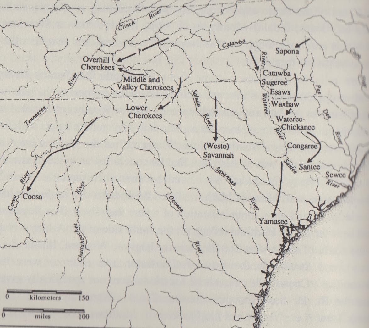
Below is a map showinig movements of most of the Eastern Siouan groups between the times of De Soto and Pardo Pardo to the middle of the 18th century, when many groups disappear from most historical records. It is taken from 'Catawba and Neighboring Groups', by Blair A. Rudes, Thomas J. Blumer, and J. Alan May, p. 302. This map does not show the movements of the Northern branch of these Eastern Siouan groups.

These groups were moving i.] towards the Catawba; or ii.] to be nearer Charleston. Both moves appear to be for safety. They were afraid of something in the interior. Was it just enemy Indians, or was it something more sinister? Then during the Yamassee many turned on the English near Charleston. Why? They were already very weak before the Yamassee war. After the war they were broken, and were more like a few refugee families scattered near their former homes. They would linger for a few decades as separate bands, but after a time they would have to assimilate, and lose their separate identites, to a large degree. Only the Catawba would remain un-assimilated, but their numbers too, would continue to decline.
Map 14.
Below we have another map from 'The Catawba Indians' by Brown. It is dated about 1725. It too, is between pages 32 and 33. The map isn't geographically accurate. At the southern end of the map is the city of Charleston. At the Northeastern end is Virginia. The northwestern end has the Cherokee, and beyond them the Chickasaw. Thee is a direct route from both Virginia and Charleston, South carolina to Nasaw, which is cited as being the Catawba. They are at the center of the map, so perhaps the map was made by a Catawba.

Between the Catawba and Virginia is only one settlement – Saxapaha. It is dated 1725 and seems be the same location as the Indians said to be on Flatt River, in 1732. See my previous blog entry. The Succa are between the Saxapaha and the Catawba. They have to be the Sugaree. The Suteree are far closer to the Catawba, due east of them. They must be the Shackori. To the south and much closer to Charleston is Charra. To their north is Youchine. What is that? Without the 'n' this becomes 'Youchie' – was there a small Yuchi/Euchee settlement there? Wiapie is next closest to the Catawba. Is this Wiamea?

There are four more communities to the South and west of the Catawba. There is the easily recognized Wateree. Then we have the Wasnisa, Casuie, and Nustie. Notice the 'Nisa' ending for Wasnisa. It is similar to Nasaw. Is this the Waxhaw? The others, I can't figure out. Maybe Congeree or Saponi? We know a band of the Saponi would move North of the Catawba near Salisbury in 1729. They were said to have been called Nasaw at times, too. Without further knowledge, I might never figure them out.
Map 15.
The map below I had earlier missed. There are several maps between pages 32 and 33 in  "The Catawba Indians" by Douglass Summers Brown. This is one that I had earlier missed, so I am adding it now, two weeks after I put up this blog post. This map, dated 1733, does show the locations of several bands at this time. It has the Keawee just to the north of the Saraw, who are on the north side of the Pedee River. Downstream from them are the Pedee. The Congaree are still on the map. To their north, in succession, are to the north the Watarees, to their east the Sugaus, to their northwest the Waxaus, then following northwards, the Sataree, and Catapaw. So we see more Catawba communities than we previously had seen, and henc his map needs to be included. Also notice there are still some Yamassee around, in the southeastern portion of the map. Please note the shrinking land base of these Indians.


Map. 16.
The map below is from 'The Catawba Indians', by Brown, between pages 32-33. It shows several Eastern Siouan communities and is dated to 1750.

Starting in the north, we have 'Cuttaboes, or Nasaue Towne' and it says 'The gate to Virginia Road'. Upstream is 'Sugar Towne', meaning the Sugaree. Just below is 'Wateree Towne'. Just beneath these are 'Wateree, Chicasaw, Sugar Ditto, and Waxahaw Towne'. There are a couple of places that look abandoned, Old Wateree Town and something that looks like a fort at the mouth of Congeree Creek.

Map 17.
In the year 1756, the following map represents the Catawba Indians. The map is from 'The Indians of the New World', by James H. Merrell, page 163.

We have Nasaw and Weyapee close together. To the south is Noostie Town. To the east we have three more towns. From north to south, they are Charrow Town, Weyane Town or ye King's Town., and Sucah Town. We have Nustie and Weyapee from the Deer skin map in the 1725. We are missing Wateree and Waxhaw towns from the 1750 map, but they are replaced by Weyane. So in only 6 years the map has changed drastically. Also the Chickasaw in their communities have gone, probably back home to Alabama and Mississippi.

All these things are background material to help understand the Saponi to their north, and what became of them. It is my hope that understanding all this background material will help us understand them, as well, and the Melungeon communities that they spawned.

Why the Decline?

I have wondered why various bands moved around so much. Why did their numbers decline so rapidly? After sme study, I think I have found four reasons -- War, slavery, disease, and assimilation. And the English settlers brought about all these things.

Wars of Conquest


The Manahoac, also recorded as Mahock, were a small group of Siouan-language American Indians in northern Virginia at the time of European contact.

The Manahoac, also recorded as Mahock, were a small group of Siouan-language American Indians in northern Virginia at the time of European contact. They numbered approximately 1,000 and lived primarily along the Rappahannock River west of modern Fredericksburg and the fall line, and east of the Blue Ridge Mountains. They united with the Monacan, the Occaneechi, the Saponi and the Tutelo. They disappeared from the historical record after 1728.[1]By the 1669 census, because of raids by enemy Iroquois tribes from the north and probably infectious disease from European contact, the Manahoac were reduced to only fifty bowmen in their former area. Their surviving people apparently joined their Monacan allies to the south immediately afterward. John Lederer recorded the "Mahock" along the James River in 1670. In 1671 Lederer passed directly through their former territory and made no mention of any inhabitants. Around the same time, the Seneca nation of the Iroquois began to claim the land as their hunting grounds by right of conquest, though they did not occupy it. [2][3][4]
  1. Johnson, M.; Hook, R. (1992), The Native Tribes of North America, Compendium Publishing, ISBN 1-872004-03-2, OCLC 29182373 
  2. Swanton, John R. (1952), The Indian Tribes of North America, Smithsonian Institution, pp. 61–62, ISBN 0-8063-1730-2, OCLC 52230544 
  3. Egloff, Keith; Woodward, Deborah (2006), First People: The Early Indians of Virginia, University of Virginia Press, p. 59, ISBN 978-0-8139-2548-6, OCLC 63807988 
  4. Fairfax Harrison, 1924, Landmarks of Old Prince William, p. 25, 33.

The Xualae were a Native American people who lived along the banks of the Great Kanawha River in what is today West Virginia, and in the westernmost counties of Virginia. The Cherokee, expanding from the south, seized these regions from them during the years 1671 to 1685.[1]

Luther Addison, 1988, The Story of Wise County, p. 6.

Eckert, Allan W., That Dark and Bloody River. (New York: Bantam Books, 1995) p. Xviii

So it appears the Six Nations forced the Eastern Siouans to abandon their lands in Northern Virginia, and the Cherokee forced the Xualla (also called Joara) to abandon their lands in Western Carolina. In fact the 'Qualla” boundary, the place where the Eastern Cherokee live today, was taken from the name “Xualla”, the people who inhabited those lands before the arrival of the Cherokee.

But there is another reason for the decline in numbers of the Eastern Siouan peoples – Slavery.

The Slave Trade

Here are a few excerpts about capturing Indian slaves from “The Indian Slave Trade” by Alan Gallay. Every serious researcher of the indians in the American Southeast should read this book. I should also warn you that it might make you cry. One reason there was so much warfare is that slave traders demanded this trade in slaves as a means for the Indians to pay off their debts. In a tyial slave raid, the men would be killed, and the women and children taken to the traders, who in turn sold these women and children on the slave markets of Charleston.

p. 60. The proprietors rhetorically asked governor Joseph Morton (September 1682-August 1684; October 1685-November 1686) why the colony had no wars with Indians when it was first founded and weak and then had warred with the Westo “while they were in treaty with that government . . . The proprietors astutely recognized the Carolinians turned them [the Westo] into enslaving Indians.” Reprehensibly then, the colony began a war with the Waniah, a group of Indians who lived along the Winyah River, “under pretense they had cut off a boat of runaways.” The Savannah [Shawnee] then captured [the] Waniah and sold them to an Indian trader who shipped them to Antigua. . . . [The proprietors] learned that the Savanah were at first not going to sell the Waniah but had been intimidated by slave traders into doing so.

p. 61. The proprietors also received word that the surviving Westo had wanted peace with Carolina . . . but the messengers were sent away to be sold. The same fate befell the messengers of the Waniah. Sarcastically the proprietors rued, “but if there be peace with the Westohs and Waniahs, where shall the Savanahs get Indians to sell the Dealers in Indians”? The proprietors were sure that the cause of both the Westo and Waniah wars, and the reason for their continuance, lay in the colonists desire to sell Indians into slavery. . . .

Even some of the Indian dealers wrote privately to the proprietor of the greed that had led to the enslavement of friendly Indians. . . . You have repaid their kindness by setting them to do all these horid wicked things to get slaves to sell to the dealers in Indians and then call it humanity to buy them and thereby keep them from being murdered. The proprietors questioned the morality of attacking all the Waneah for the crimes of a few . . .

p. 62. In 1680, they [the proprietors] limited enslavemet of Native Americans to those who lived more than 200 miles from Carolina, though they left the door open to abuse by stipulating this applied only to Indians in league or friendly to the colony. This law might explain why the Saura moved from the Dan River to the Pedee. It would have been harder for the slave raiding Shawnee and Seneca to get to them. And being nearer Charleston, they were within he 200 mile range spoken of in this law.

p. 210-211. The Catawba was a name the English used to describe many of the Piedmont Indian groups of both North and South Carolina (20).. . . .The Catawba, under Carolinian beckoning, official or otherwise, had prayed on the Savannah (Shawnee) . . . The Savannah, probably in revenge, then attacked some of the Northward Indians, a designation the colony used to describe the Catawba and other Indians of the Piedmont.. They also carried away several of our Indian slaves away with them (21) (about 1703). Bull appeared in October 1707 and reported that he had learned from the Shutteree, a Piedmont group, that 130 Indians calling themselves Savannah and Senatuees (Santees?) [Vance's note: The author is wrong – has to be Seneca's. The Santees were allied to the Piedmont Indians whereas the Seneca were their enemies] fell on them. . . . The force carried away 45 women and children, but mostly children. A Cheraw Indian (from a group then in the Piedmont) informed Bull that the attackers traded with the white men at their own homes and that they lived but 30 days journey from us. Apparently, if this report was correct, the Savannah were selling their captives in Virginia, Maryland, or Pennsylvania. . . . (26) as for the Savannah, not all of them would leave the colony. About a third of the population remained I their settlements along the Savannah River. (27-28) Those who left would continue their attacks on the Piedmont Peoples.

p 239. One of the evils he noted in this and other letters concerned the enslavement of peaceful Indians, which threatened the harmony of the province. One can almost hear him sigh with resignation when he recorded: “I hear that our confederate Indians are now sent to war by our traders to get slaves.” (55)

p. 242-3. The commission of the Indian trade met first on September 20, 1710 in Charles Town. . . . The commission undertook a flurry of business, mostly hearing complaints against traders for illegal enslavement of free Indians . . . The establishment of the commission opened a floodgate of grievances against the traders for crimes against the traders for crimes ranging from assault and battery to kidnapping, rape and the enslavement of free people.

Heard enough yet? Well I have. Now to the statistics Gallay brings out. He goes on to say after the Yamasee war, Indian slavery gradually died out by 1720. I suspect the reason is that there just were no more easily obtained Indians to enslave. At one point in the book the traders boast that there are no more Indians in Florida, as they have all been taken as slaves. When Gallay speaks of Piedmont or low country Indians, he is talking of the Eastern Siouan peoples, the Catawba and members of the Catawba Confederation. He continues;

p. 298-299. There is no telling how many Piedmont and low country Indians . . . were enslaved . . . and there is evidence all members of these groups were enslaved, but there are no numbers . . . The Lord Propritors frequently complained of illegal enslavement . . . all told, 30,000 to 50,000 is the likely range of Amerindians captured directly by the British, or by Native Americans for sale to the British., and enslaved before 1715.

Gallay says the numbers enslaved ranged from a low range of 24,000 to 32,000, to a high range of 51,000. He also ads that excluding the Creek, Cherokee, Savannah, and Piedmont Indians, 25,000 to 40,000 were enslaved. Doing the math, knowing there were few Creek and Cherokee enslaved, we have a low range of between 5,000-7,000, to an upper range of 10,000-11,000 of these Piedmont Indians were enslaved, from the period of 1670-1715. Various Indian tribes went to war to capture enemy Indians, and sell them to the English, who in turn exported them to the Caribbean, exchanging them for African slaves. American Indians would just run away the first chance they got, living off the land until they arrived back home. But the Africans were afraid to run away, not knowing the landscape very well, and being afraid of the American Indians they might run across.

He continues on page 299, to say “What is surprising about these figures is that Carolina exported more slaves than it imported before 1715.”

Disease

p 90. The Catawba Indians, by Douglas Sommers Brown; The Congarees were a “comely sort of Indian”, who had already been much reduced in numbers by small-pox. Date is about 1718.

p 154 The Catawbas however, were greatly dissatisfied with the Charles Town traffic, (May 1718),. . . but most of all, the Catawbas were tired of serving as burdeners, the cause of their losing so many men” Brown says, quoting Wiggan, “the burdeners were quickly sent back to the Nation because of their getting the small pox in our settlements.”

p 180; The Catawba Nation had interittenly been attacked by an enemy even more formidable than either the white settlers or their northern enemies. The other assailant was small pox. Brown goes on to say it had appeared as early as 1697.Lawson says the disease had been among the Catawba shortly before his visit. In 1738 spallpox spread throughout Catawba country, according to Adair.

p. 181. The South Carolina Gazette in 1759 reported that it is pretty ecrtain that the small pox has lately raged with great violenceamong the Catawba Indians,, and that it has carried off near one half of that nation. . . The Warriors returned from Fort Duquense had brought small pox back with them.

Per Brown (same page) Maurice Moore wrote, “Their numbers were reduced to less than one half . . . by the small pox. The tradition that I heard in my boyhood was that it was introduced through the avarice of some of the White men. There is a citation and a note saying “It is not inconcieveable that such an atrocity was perpetrated. When Jeffrey Amherst, England's commander in chief in North America, heard of the outbreak of Pontiac's War, he instructed Col. Henry Bouquet, saying, I wish to hear of no prisoners . . . could it not be contrived to send the small pox among these disaffected tribes of Indians?” (see Van Every, “Forth to the Wilderness”, p. 10).

Assimilation

There is only one band of the Eastern Siouan tribes that is federally recognized – the Catawba. Some Tutelo descendants are part of the Six Nations. It is known that some federally recognized tribes adopted known Catawba (Creek, Cherokee and Choctaw). The Lumbee have been fighting for recognition for 150 years, longer than probably any other tribe. There are several state recognized bands – Occoneechi Band of the Saponi, the Sapony, Haliwa, Monacan, Waccamaw. The Melungeons can prove a Saponi heritage, but to my knowledge, have never considered trying for federal recognition. But for the most part, the federal government has decided that these descendants have already been totally assimilated into American Culture, have a minimal amount of American Indian blood and DNA, and therefore do not deserve the right to be considered American Indian, with the status that goes along with it.

Conclusion

The Eastern Siouans, at the time of first contact with Europeans, were a strong people, from West Virginia in the north, through the Southern Appalachians, Virginia and the Carolinas to the Atlantic coast of South Carolina. Through periodic small pox epidemics, constant warfare, the slave trade and finally assimilation through cultural contact and intermarriage, the culture has virtually died. Were it not for the English settlers, none of these things would have happened. Granted, they were perpetually at war with their neighbors, but it was not a war to extinction. The English traders demanded war, and they demanded the capture of slaves to settle their debts to the traders. This caused both the Tuscarora and the Yamassee Wars, that spelled the end of several Eastern Siouan Bands. Only a few Indians remained, scattered wherever they could live.

These things are a prerequisite to understanding mixed race peoples, such as the Melungeons, or others similar to them.


Thursday, February 13, 2014

Saponi Indians from Fort Cristanna to the Melungeons of Southern Appalachia


Saponi Indians from Fort Cristanna to the Melungeons of Southern Appalachia
There are people online who think the Melungeons said they were "Indian" because they did not want to be thought of as mixed with Negro. NO! This is a LIE! The reason some said they were Portuguese was so they would not be subject to the Jim Crow laws! But they are recorded as being American Indian. I hope the writing below will show the EXACT ROUTE the Saponi took from Fort Christanna to the lands where the Melungeons were first found, and the word first used. We will show the word came from the French "melangeon (meaning "we mix").

Dr. Richard Allen Carlson wrote his Ph. D. dissertation on the Melungeons, a people of Saponi Indian descent. I intend to quote a part of it, with comments.

As a result of the Treaty of Middle Plantatin of 1677, the Saponi were one of several tributary tribes of Virginia. On page 59, Carlson talks of Virginia Governor Spotswood long desiring to educate the Indians.

A copy of the treaty is located at http://encyclopediavirginia.org/Articles_of_Peace_1677 . From http://en.wikipedia.org/wiki/Treaty_of_1677, we know there are some signers of this treaty that are not listed at the above link. The names of the signers of the treaty are below:
Governor Spotswood had settled several hundred Saponi Indians at a place called Fort Christina, located on the Meherrin River. In 1716, Governor Spotswood made a trip to Christanna with French Huguenot clergyman, Rev. John Fontaine. Rev. Fontaine is surprized that some of the Indians can speak good English.

Carlson reports (p 64); Fontaine spent a considerable amount of time conversing with the instructor of the Sapni Indian school, Rev. Charles Griffin. Frustrated at the repeated denials from the Virginia Council to fund a missionary schoolteacher for the Saponi, Spotswood still personally employed the English Clergyman. Fountaine found Griffin enthusiastically carrying out his mission “to teach the Indian children and bring them to Christianity”. Besides running the Fort’s church, Reverend Griffin’s work among the Saponi involved teaching their children to read the Bible and repeat “common prayers”. He was also teaching broader skills in speaking, reading, and writing English, and Fontaine noted he “hath had good success amongst them.” One evening Fontaine attended a common prayer reading and noted that the eight Indian boys participating “answered very well to their prayers and understand what is read.” [133]

Carlson speaks of several attacks from the Five Nations Indians and others, upon the Saponi and mentions the killing of some Catawba’s, who are allies of the Saponi. He says (p 69) despite the peace made in 1718, the Iroquois attacked again in 1722. [150]. Recall the Indian slave trade and how most of the wars were started by traders who wanted captured Indians for the slave trade. It was about this time that the Indian slave trade came to an end. They were simply running out of Indians to enslave. On page 52, Carlson speaks of the Saponi, mentioning how in 1732, William Byrd III spoke of the Indians at Fort Fort Christanna, saying they were really a consolidation of several tribes; and “each of these was formerly a distinct Nation, or rather several clans or canton’s of the same Nation, speaking the same language, and using the same Customs.”

More about Rev. John Fontaine

Rev. John Fontaine wrote a memoir entitled “Journal of John Fontaine: An Irish Huguenot Son in Spain and Virginia, 1710-1719”.

At http://www.virginiaplaces.org/settleland/fontaine.html there is a section on the Huguenots. Several paragraphs ane dedicated to this Rev. John Fontaine. Quoting from it, we have;

John Fontaine's father and grandfather were Huguenots who suffered official persecution by the Catholics in France. In 1693 John was born in England, to which his father had fled as a refugee. His father then migrated to Ireland, and succeeded in getting John a commission in an Irish regiment in 1710. John Fontaine served briefly in Spain, then investigated Virginia in 1715-19 before returning to England.


Learn more about Virginia’s Huguenot peoples at the link above.

There are some interesting comments about the Indians way of life. First is the mention of corn. Carlson is paraphrasing Byrd. When talking of the colonists he calls “borderers”, meaning the people that lived on the Virginia/North Carolina border (P. 82), Byrd also decries the “borderers” means of economy and subsistence; especially in North Carolina where he contemptuously stated they raised Indian corn instead of tobacco and fruit orchards which he blamed on laziness. Indian corn, he noted; “. . . is of so great increase that a little pains will subsist a very large family with bread . . .”

Concerning sex between races, Carlson again turns to Byrd, saying; Byrd and a few other ex-traders of the survey team would make a side trip into Virginia in hopes of finding some “entertainment” in the Nottaway Indian Town. The entertainment the surveyers sought out among the Nottaway turns out to have been sexual in nature. After mentioning two “pretty English women, the narrative continues; . . . we could find it in our hearts to change these fair beauties for the copper coloured ones of Nottaway Town.” Continuing to quote Byrd, Carlson writes of him; He wrote in that evenings journal entry that the Nottaway “offered us no bed fellows, according to the good Indian fashion, which we had reason to take unkindly.”

Continuing on this theme, Carlson writes (P. 85), quoting Byrd, “. . .one way of converting these poor infidels, and reclaiming them from barbarity and that is, charitably intermarry with them according with the modern policy of the most Christian King in Canada and Louisiana.” He continues saying that had the English done as the French, the country would be swarming with more people than it has insects, and . . . even their copper coloured complexion would admit of bleaching, if not in the first, at the farthest in the second generation . . . it is strange, therefore, that any good Christian should have refused a wholesome, straight bed-fellow, when he might have so fair a portion with her, as the merit of saving her soul.[210].

Byrd had a Saponi guide, Ned Bearskin. It was said this was his hunting name. Ned it was said, was a great hunter and kept them fed. It was said that Ned spoke English very well. Mention was made of seeing the smoke of Northern Indians, enemies of the Eastern Siouan Indians, as they were “firing the woods”, as was the Indian custom. Rev. Peter Fontaine brother of Rev John Fontaine who had visited Fort Christanna years earlier, both French Huguenots, was also on this journey with Byrd and Ned Bearskin. Notice they are talking of mixed race Saponi. Notice also Byrd being upset because when visiting the Nottaway, they were not offered any 'bedfellows' as was the 'good Indian fashion'. It is possible some of these Indians were already of mixed blood heritage.

Troubles with Neighboring Tribes

There is a story of an Indian named “Sawney” who had recently returned to Virginia from Canada. He had been captured by the “French Indians”. Somehow he escaped about 1724 and returned to Virginia, with aid from John Collins. Once in Virginia, he was arrested and was accused of threatening the inhabitants with incursions from his former allies, the “French Indians” from Canada.

Well, the Northern Indians did continue their attacks in Virginia. Carlson says; “More Virginia settlers were killed by Iroquois in the winter of 1725-1726 . . . the sachems of the Five Nations replied . . . it was some of their warriors operating without authority in conjunction with some French Indians and Tuscaroras who committed the killings.”[151] The sachems of the Iroquois defended their warriors, saying the killing of the Virginians was a mistake, and that they were really after “enemy Indians”. It was recorded that about this time, seven Saponi (other sources call them Catawba) were killed or captured by some Tuscarora warriors. They could capture and sell “enemy Indians” to the English. By custom, they would kill the men and sell the women and children. The era of selling Indians was coming to an end, as there just were no more Indians left to enslave.

In 1727 the Saponi came to the Virginia Assembly in Williamsburg and asked for satisfaction. The Saponi said in the Virginians took no action on the Tuscarora, they would take the matter into their own hands. Well, Virginia did nothing, so the Saponi went to the Catawba, who did take action.

There was an attack on the Meherrin Indians, who complained to the same Virginia Assembly the Saponis had complained to the pevious year. They blaimed the Occoneechi’s and Saponis. And the Nottaways complained the Meherrins had attacked them. The Saponis with the Catawba attacked the Tuscarora, of King Blount’s Town. North Carolina officials meanwhile, blamed the Catawba and the primary instigator of these feuds, also holding the Saponi and Occoneechi responsible.

Governor Spotswood had retired and was replaced by Governor Gooch, and he was not as friendly towards the Saponi as his predecessor. The Virginians had done nothing to help the Saponi when they asked for help after seven of their men were killed, while the Catawba did come to their aid. To add to this mistrust, three Saponi men were accused of killing two Nottaway’s. Three Saponi chiefs were held in jail until those guilty of the killings were brought forward. The killing of the son of the Tutelo chief also added fuel to the fire. A report came in (page 76) that John Sauna (Sawnie) and a fellow named Ben Harrison (apparently an Indian named after the White trader), went south to bring up one hundred Catawba warriors to protest the incarceration of the three Saponi men . . . the Saponi said that if Captain Tom was hung, they would take their wives and children over the Roanoke, and then return to drive the Whites and Negroes to the James River, and go to war. [181]

The Tutelo king, grieving over the death of his son, threatened the life of the governor, saying then he’d go off to some foreign Indians. The old Tutelo king was ordered to be arrested, but Carlson says he found no evidence that this ever happened. Acording to Carlson, Byrd stated (p 93) that the executions by the colonists of three Saponi caused the Saponi to remove to the Catawba’s.

From Saponi to Melungeon

The next section covers the migrations of the Saponi Indians until one branch migrated to Southwestern Virginia and Northeastern Tennessee, where they will become known as “Melungeons.” They are NOT Portuguese or of Mediterrainan origin, they are not mixed White and Blacks, with no Indian component as some suggest. In fact the only reason they migrated together was because of their American Indian blood.

(P. 91) Speaking of March 1729, Carlson writes; “. . .most of the Saponi were still at Christanna in June, although some families had already left to join the Catawba and/or other Tutelo now living far from the Christanna reservation.” One of the main reasons that the Saponi left Christanna was the hanging of a Saponi elder. A drunken Saponi leader had earlier killed an Englishman. (P. 93). Carlson states “. . . the Sapony’s took this so much to heart, that soon after quitted their settlement and moved in a body to the Catawbas.[233]

By late in the summer of 1729, the Saponi and confederated bands and families that remained with them finally departed the Christanna Reservation. This abandonment of the Reservation would begin a diaspora of the people that once resided there. Comments later made by John Mitchell in 1755 stated that, in 1729, both the Saponi and the Tutelo “had removed further South upon the heads of the Pee Dee”at the Northern end of what was known as Catawba Territory. Byrd also noted that the Saponi removed to Catawba Territory that year. He explained that this people is now made up of the remnant of several other nations, of which the most considerable are the Saponey’s, Occoneechi’s, and the Steukenhocks,, who not finding themselves separately numerous enough for their defence, have agreed to unite into one body, and all of them now go under the name of the Sappony. . . A French map published late in 1729 reveals that one faction labeled labeled the “Sapon Nahisan”had removed far west from the extent of settlement far up on the headwaters of the Roanoke River. [233, 234]

So by going to 'the headwaters of the Pee Dee' in 1729, you will see the Saponi went back to where they were about 1700 (see map 7), before they went to Fort Christanna. Maps put them near the present vicinity of Salisbury, North Carolina. The report that they went to the head waters of the Roanoke River is somewhat ambigious, without seeing the map itself. The Roankoe River divides in two. The southern branch being the Dan, the northern branch being the Staunton. It seems this band was about half way between where the Melungeons ended up in Southwestern Virginia, and the modern Monacans of Amherst County.

As for the Tutelo, (P. 94) Carlson says they wondered up and down the Appalachians until by 1740 they joined their old enemies, the Iroquois. In 1730 (P. 95) the Catawba and Saponi living with them, asked to make a treaty with Virginia. Nothing came of it. In 1732, Byrd, speaking of the Catawba, said “their population of more than 400 fighting men was spread through six towns on the Santee River in Carolina along a 20 mile stretch.” [240, 241].

This agrees with the two maps dating back to about 1750 (maps 17 annd 18). I have no maps dating to the 1730s. With the end of Indian slave raids, there is a little stability apparently, from the 1730s to the 1750s. But the bands are still weak, and in an uncertain state of stability. Since they left Fort Christanna, they were no longer considered “Tributary” Indians. Yet they had to leave Fort Christanna. The English didn't seem to understand they were forced to live next door to their traditional enemies. They were safer nearer the Catawba.

Dr. Carlson speaks of a third band. One, the Tutelo, went North to live with Six Nations. A second that went south to live with the Catawba. And a third, that went to live on ex-Governor Spotswood's lands, in Orange County, Virginia, by the N. Anna River. Later he will talk about others who went to live near the headwaters of the Flatt River about 1732, the Occoneechi. This is the group from which the Melungeons descend. According to Carlson, this band was called the “Christian Band” of the Saponi. They are the ones that more closely listened to the Reverend Charles Griffin. Being Christian, they would also have been more likely to have listened to the French Hugeunot ministers, the Fontaine brothers, Rev. John and Rev. Peter Fontaine. Much of the rest of this study will refer to this “Christian Band”.

The map below shows the Saponi movements from Fort Christanna to several locations. These are called Aconatzy (Occoneechi) on maps, per Carlson. One going towards Flatt River by 1732, a second towards the Appalachians (called Tutelo) who are in Canada by 1740. A third band are near Salisbury, North Carolina, just to the North of the main Catawba cities, by 1729. A fourth will arrive on the lands of ex-Governor Spotswood by 1738.

Also note the location of the Catawba, Cheraw, and Waccamaw. The Catawba (federally recognized) and Waccamaw (state recognized) are located in the same places as they are to this day, and the Cheraw of the 1720s and 1730s were located where the Lumbee are located today.

Please forgive the quality of the maps. I found the map and had a printer, a scanner, and a pen. . .


Saponi on ex-Governor Spotswood's Land

Orange County records from 1738-1743 refer to several Saponi living in the area. They include Alex Machartion, John Collins, John Bowling, Charles Griffen, and other “Christian Indians.” The following names are also mentioned – Manincassa, Foolish Jack, Little Jack, Isaac, Harry, Captain Tom and Blind Tom. Charles Griffen appears to have taken his name from Rev. Griffin, a former school teacher at the Fort Christanna school. Captain Joseph Collins negotiated the release of Sauna from the “French Indians” in 1722. Carlson speculated the Machartion surname might have evolved into McCarty and McCarta surnames associated with the Collinses in the next century. Carlson speculates p 107, “evidence available from written records made subsequent to 1743, it is quite possible to surmise that John Collins is the son of “Captain Tom”, for an elder named Tom Collins is shown living with John and the rest of the Christian Saponi in the years immediately following their expulsion from Orange County. If this is so, one might further speculate that Blind Tom is Tom’s father.” Remember one of the three Saponi chiefs mentioned earlier at Fort Christanna, one of the three who was killed, was named 'Captain Tom'. These three deaths generated the departure of the Saponi from Fort Christanna.

Carlson suspects the Bowling surname came amongst the Christian Band of the Saponi in the 1730s while living in Amelia County. The well known Powhattan mixed-blood family had for generations operated a trading house at the Falls of the Appomattox.

Per Carlton, “Exactly when and how the treaty obligations stemming from the 1677 and subsequent agreements with the Saponi were abolished, ignored or forgotten by Virginia authorities is not known. After 1733 no mention of the colony recognizing any treaty obligations to the Saponi appears in Virginia records. Regardless, by at least 1738, the Christian Saponi were being treated as Individual Citizen Indians a opposed to the political entity of ‘Tributary Indians’. I suspect the Indians, once they left Fort Christanna, lost their status as 'Tributary' Indians.

Carlton says . . . in 1743 the Christian Saponi went south to live near Catawba lands, however by 1745 they were back in Virginia, in Louisa County, near to their former lands in Orange County (p 111), in the mountains south of Rapidan Station. The Christian Saponi would reside in the area for some time and would be noted as “Nassayn” (Saponi for ‘the People’) on 1749-1750 era maps.[285] Names listed living in this area are Sam and William Collins, along men named George and Thomas Gibson, Sam Bunch, Ben Branham, and a few others were charged with by Louisa County court of ‘concealing tithables’. . . . [286]. The surname “Branham” is associated with the state recognized Monacan Tribe of Amherst County, Virginia, today. Bunch is associated with the Catawba and other bands. Below is a second map of the the movements of these Christian Saponi.

On page 112, “The likely source for the charge . . . was Virginia law that stipulated that, in addition to all adult males,all Indian, Negro and Mulatto women over 16 years of age were also tithable, unlike white women of the same age. . .The Christian Saponi may have felt they should be free from taxation a rightful heirs of the Tributary Nation. But as far as the Virginia government was concerned, ‘tributary status no longer applied. This being the case, they would now have to be subject to the Virginia Act of May 1723. The act stipulated that ‘all free Negroes, mulattos, Indians, (except tributary Indians to this government) male and female, above 16 years, and all wives of such Negroes, mulattos, or Indians (except Indians tributary to this government) shall be accounted tithable. . . . Social and economic barriers based on race labels would become a greater concern for these Christian Indians now that they had lost their political status as tributary Indians. [287]. So for those who claim that these tithables in these households meant these were mixed race Negroes – well, no it doesn't. They could always be American Indians, or mixed race Indians, as well as Free Negroes or mixed race Negroes. Also know a mixed race Indian, as well as a mixed race Negro, was considered a “Mulatto”.

We have followed the documentation of the Saponi Indians from 1729-1743. The presense amongst them of a "Charley Griffen" ties them back to old Fort Christanna, and the teacher Reverend Griffin. Once they left Christanna, they lived for a time with the Catawba, and for a time with former Governor Spotswood. They wondered, like the Hebrew of old, in search of new homes, with tribal unity disappearing, as a few remote families are gradually being absorbed into the frontier lifestyles of their white neighbors. In 1743 families again started to return to the Catawba. They simply didn't know where to go or what to do. The next section covers the timeframe when these Christian Saponi Indians became known more commonly a "Melungeons." Later we will see a known Melungeon named “Griffen Collins”, completing the circle from this bunch of Collins known as Saponi Indians, through this same line to the Melungeons. In fact I don't think any bunch of state recognized Saponi peoples has as much proof of their origin as do the Melungeon peoples, and the Melungeons are not state recognized.

By 1747, Thomas Collins obtained some land in Louisa County, Virginia. Gilbert Gibson’s land was adjacent to Collins’ place. Carlson believes Thomas Gibson and Gilbert are closely related. This is the same Thomas accused of concealing tithables in 1745 in Louisa County.

Tom Gibson, here is what Carlson says pertaining to him and the migration of these Saponi (p. 115); “later in 1751, Tom Gibson received a noticeably large grant from the prominent ‘Earl of Glanville’ of 640 acres on the Flatt River adjoining John Collins . . . the Christian Saponi’s choice of resettling at Flatt River must be more that in interesting coincidence . . . documents produced during the decade would show that these had settled among or immediately adjoining the remaining band of Occoneechi Indians who had removed here somewhere around 1732. Carlson paraphrasing Ramsey, saying; “up until the late 1750s, John Eaton, Ephraim Osborne, William Harrison and other colonists using the Trading Ford as a place to trade with the Saponi, Cherokees, and Catawba. . . .” Carlson adds; “Mitchell’s map also identifies the Aconeechy living on Flatt River. Bowen’s 1752 map also shows the ancient title of Occoneechi was being applied towards the Indians living at the junction of the Flatt and Little River where the trading Path crosses them. Mitchell’s well known 1754-1755 map [299] of North America then adds to the complexity of the picture. He shows one band of the Occoneechi where Bowen did three years prior at the mouth of the Flatt exactly where the Christian Saponi from Virginia settled in 1750. But Mitchell also shows yet another Aconeechy Town [300,301] a dozen miles upstream at the headwaters of the Flatt. . . .

(p. 116) The cartographic division of the Occoneechi bands on the Flatt from one village in 1752 to two in 1755, coincides perfectly with the immigration of the Christian Saponi families from Virginia to the area. . . . following a sickness epidemic and a series of attacks on the Catawba towns to the southwest in 1753, which prompted a portion of the Catawba Saponi band to temporarily move into this part of North Carolina. Primary documents cited by Tilley show that from 1753-1758 this band of about 30 Saponi were living just North of the Flatt River in Granville County. Their location was reported to be on the lands of William Eaton, and is thought by one local historian to be those lands Eaton held just north of present day Henderson. . . unlike the Christian Saponi, these Saponi still required an interpreter . . . William Eaton filled this position . . . the Christian Saponi had not used an interpreter for more than fifteen years. Carlson continues; . . . Granville County authorities reported that about ’12 or 14 Sapona men and as many women and children’ were living among William Eaton’s regiment in Glanville County in 1753-1754, and these Saponi had newly come up from Cheraw (Sara) Town in the Catawba Nation. . . . In a 1755 document citing figures used by the governor, Moravian Bishop A. Spangenburg claimed that 28 Saponi had recently moved to Granville County from Virginia. Because Granville County embraced Orange County just prior to that Bishop’s publication, it is clear that the Bishop was referring to the Christian Band of Saponi ...

Carlson begins; “From 1750 to the Revolution, the Christian Saponni families remained split between the Louisa County mountains in Virginia and the more distinct Flatt River Community down in North Carolina”.He says other mixed race families joined there on Flatt River – the Sizemore’s and the Ridley’s, or Riddle’s. After the proclamation of 1763, he speaks of the Flatt River Indians moving again, further west in North Carolina and Virginia. Carlson mentions Tom Gibson again, saying he obtained more land, bordering lands obtained by Tom Collins and George Gibson, and an Indian man named Moses Ridley/Riddle. [314, 315, 316, and 317]

Carlson reveals (p. 120); “Documents such as tax records reveal that, in the first few years on the Flatt, the people of the Christian Saponi Band were enumerated as “White tithables”. [ 309] Soon after Orange County was formed from Granville in 1753,new county officials chose to count the citizen Indians . . . as Molatas . . . Virginia and North Carolina law stipulated that individuals of half Indian and half White heritage to be labeled ‘mulatto’, while individuals less that half Indian could be deemed ‘White’. [310] In Virginia, any person that was of 1/16th African heritage or more was to be recorded as ‘mulatto’, regardless of the character of the remainder of their blood quantum.

The author talks about a Sizemore man being recorded as a ‘mulatta’. Then the author gets interesting, as far as I am concerned. He says; . . .three years prior [meaning abt 1750] Ephriam [Sizemore], George Sizemore,and William Joiner were counted among ‘an old Indian man’s list’ of Indian and/or mixed blood families living at the time in Lunenburg County, Virginia. [312].  . . one may surmise that these men were counted as ‘citizen-Indians’ at that time, and no tribal identification was shown.”  


Origin of the term Melungeon

The next map has the greatest concentration of Eastern Siouan peoples at about the time of the American Revolution. You can click on the map to enlarge it.

In a letter dated March 30, 1757, Rev. Peter Fontaine, the brother of Rev. John Fontaine (both French Huguenots who spoke the French language fluently) who had visited Fort Christanna several decades earlier. Peter was said to have commented that the colonist’s “ought to have intermarried with the Indians [more frequently], thereby allowing [them to be] more easily convert[ed] to Christianity. . . . The French Reverend derided English Colonial authorities for discouraging marital liaisons between Indians and Whites. He also noted his concern with physical appearance by claiming that would result in ‘Indian children as white at birth as Portuguese or Spaniard.’ From early days, early colonists realized that mixed race children looked somewhat like Spaniards or Portuguese.

Throughout the Seven Years War, the Catawba and their allies were courted. But the Flatt River Indians, per Carlson (p. 128), were also being treated poorly, with several law suits against them. By about 1770, many of them had started to return to Virginia. Carlson says, “By 1770, most of the Flatt River Indians had removed back to the mountains of Virginia. It appears debts, stricter hunting and tax laws, in combination with the passing of the infamous Proclomation of 1763 and a growing non-Indian population around Flatt River, would all be factors that played a role in prompting this move.”[338,339]

I suspect it was the Reverend Peter Fontaine, or some of his family members, might have been the origin of the term “Melungeon”. His words might also explain why some non-Indians considered the possibility that these mixed race peoples might be Portuguese or Spanish instead of Indian-mixed. Also please note the location of these Flatt River communities. They were very near the exact locations of several of the state recognized Eastern Siouan tribes, as they exist today. We first find the word “Melungeon” recorded about a half century after this, but this appears to be the most likely origin of the term. I can easily see Rev. Fontaine smiling when he might have seen this band of the Saponi, and saying, “Ah, some mixed race Indians! We have mixed!” In French, “melangeon” literally means, “we mix”, in English.

Small Pox

On page 129 Carlson says; “Compared to the Cherokee, the Catawba and their confederates were a relatively small population to start, and the war and recent small pox epidemics had taken their toll on adult Catawba males.”

The war referred to was called in Europe The Seven Years War, but in America it was referred to as the French and Indian War. Chistopher Gist played a prominent role in that war. I am also a Gist descended from the same line of Maryland Gist’s. The best book documenting them is Christopher Gist of Maryland and Some of His Descendants 1679-1957; by Jean Muir Dorsey and Maxwell Jay Dorsey. There is a more recent four volume set, “A Face to My Name”, by Sheri McNeil Savory that is also excellent. Christopher and Nathaniel Sr (whom I descend from) are recorded as being brothers.

But Carlson also refers to a small pox epidemic. I am reminded of what the Dorsey’s said; p 28 -- "Christopher Gist died of Small Pox on the road from Williamsburg to Winchester on July 25th, 1759. He was conducting 62 hand-picked Catawba Warriors to Winchester to help guard the western frontier of Virginia ((ibid., series 21664, part 1, , pp 216-217). It continues to say that these Catawba were urged to continue "but they said their father Capt. Gist (as they called him) was dead at it was better for them to return home (ibid., p. 302)."The Dorsey’s were referring to "The Papers of Colonel Henry Boquet". Other books on the Catawba refer to this 1759 epidemic as something similar to the straw that broke the camel’s back. One writer says or implies two-thirds of the Catawba died during this tragic epidemic. What was six Catawba towns moves down stream a few miles, and only two Catawba towns are remaining afterwards. Carlson also states, . . . in 1764, a large contingent of Catawba who could muster 150 warriors were reported to be found wondering on the frontiers of North Carolina and they too had made peace with the Cherokee and the colonists. [343, 344]. If the Catawba could muster only 150 warriors, this means they had perhaps only 600 Catawba in total. A contingent of these were discovered “wondering” on the frontiers of North Carolina. This means the western parts of North Carolina. Now they had to have made some agreement with the Cherokee, to move to this region, as they were a far more powerful nation, and they too lived in the far western parts of North Carolina. Were some of these people later described as “Melungeons”?

Carlson speaks of some of the Louisa County and Flatt River Saponi communities moving back together on the frontier by the end of the 1760s. He says – They would consolidate into a new community right at the New River boundary between Virginia and North Carolina and the lands of the Cherokee Nation, technically beyond the settler zone. Carlson states families from both Louisa County, and the Flatt River Community, came to live on New River, and are recorded as living there in 1770 and 1771. On the map, you will see “White Top Mountain” is the location where the New River passes over the North Carolina/Virginia border. Recall the people known as “White Top Mountain Cherokees”. They were largely descendants of Ned Sizemore. They attempted, in mass, to enroll in the Cherokee Nation in the Guion-Miller Roll, early in the 20th century. But some of their applications even said that they came from “the Catawba Reservation”.

By page 133, Carlson is talking about Forts in southwestern Virginia, from 1770 on. These forts were manned by local farmer/hunter/militiamen. Some of these were the Christian Saponi. He mentions 1773-1774 “Delinquent Tax List” of Boteourt and Montgomery Counties, saying; “These lists show the names of over a dozen adult males of the Christian Saponi and families residing primarily on “Indian Lands” off the New River and Reed’s Creek.”[352,353]

Of these forts, Carlson also discusses those that would be locations associated with Nathaniel Gist. He says; “Some of these early fromtier forts and the people who occupied them would later enter into the history of the Christian Saponi of New River. These would include the fort that the Moore brothers of Castlewood, not far to the northwest of the New River in 1769. In 1772, Mathias, Jacob, and Henry Harmon emigrated from near Salisbury in North Carolina and established a defensive family compound on Carr’s Creek off the Clinch River. The most significant of such forts to later Saponi history however, would be Blackmore’s Fort, which was also established in 1772. This fort was constructed on the lands acquired by Captain John Blackmore located at the mouth of Stoney Creek on the Clinch River. [351]

Now Castlewoods, mentioned above, was where the Moore brothers lived.

http://www.rootsweb.ancestry.com/~varussel/indian/28.html

We the Commissioners, etc...do certify that John Dickerson, heir-at-law to Humphrey Dickerson, who was assignee of Joseph Blackmore, who was assignee ofNathaniel Gist is entitled to 310 acres of land lying in Washington county on the north side of Clynch River in Cassell's Woods, to include his improvement. Surveyed the 28th day of May, 1774. [Vance’s note: when discussing the Melungeons, recall Jarvis words, where he said the whites “with the friendly Indians” built Fort Blackmore. OUR Nathaniel Gist – not the famous Nathaniel Gist, but his first cousin — KNEW Joseph Blackmore. Again, interesting.]

http://www.rootsweb.ancestry.com/~varussel/indian/79.html

At the above link we have “The above writer is referring to the children of Joseph Blackmore, for Captain John Blackmore, builder of Blackmore’s Fort, had in the year 1779, left for the area for settlement on the Cumberland in Tennessee. Joseph Blackmore was a brother of Captain John, and owned the adjoining farm to the old Fort tract to the south and down Clinch River.” Joseph and John Blackmore were brothers, and John Built Fort Blackmore, famous in the history of the Melungeons as having been built by the “friendly Indians” who seem to have been relatives of the Catawba, NOT the Cherokee. Those Catawba keep popping up, even here with respect to Nathaniel Gist. It makes me wonder when the Cherokee themselves say his paternal grandpa was White implying his father was half Indian. What if his father was half Catawba, not Cherokee? Well that changes things a bit . . . The Nathaniel mentioned above was killed in 1780 at The Battle of Kings Mountain during the Revolutionary War. The Nathaniel mentioned below is either his son, or the son of his brother, Richard Gist, who was also killed at Kings Mountain.

http://www.rootsweb.ancestry.com/~varussel/landgrants/washcosurvbk.html

Page 149 - Richard Moor...390ac...Commissioners Certificate...on the waters of Beaver Creek, north branch of Holston River...Beginning on the north side of the big ridge...corner to Cornelius Carmacks land he now lives on...corner to Carmack & Nathaniel Gist...June 6, 1782 - Richard Moore...390 ac on a branch of Beaver Creek, surveyed on January 12, 1775, includes improvements, actual settlement made in 1774...August 17, 1781 Page 151 - Nathaniel Gist...200 ac...Preemption Warrant #1972...on the waters of Beaver Creek, north branch of Holstein River...Beginning corner to Cornelius Carmacks land he now lives on...corner to Richard Moors land he now lives on...June 5, 1782

Now this Nathaniel Gist (p. 149) is the son of either Richard or Nathaniel II, both sons of Nathaniel I, b. 1707. He may very well be the Nathaniel found later near Somerset, in South central Kentucky, or the two might be first cousins, one the son of Nathaniel, the other the son of Richard. AT any rate, notice the “Moor” surname that Carlson also mentions. Also note the Moores lived at “Castlewood” and that Joseph Blackmore was assignee of Nathaniel Gist, for the lands of Cassal's Wood, later known as Castlewood. Since I descend from these Gist's, and from the Waylands also mentioned living in a Melungeon community (we will get to them later) in the 1790's, I have some interest in these things.

Other families Carlson associates with the Christian Saponi living on/near the New River are the Bunches, Colins, Gibson’s, Sexton’s, Bowlings, Aicee/Sicee, which Carlson says was Anglicized to “Thomas”.

The fact these families were said to have settled on “Indian Lands” has cause some comments by Carlson’s. he says; “It might be assumed that the Indians had settled beyond the 1763 Proclamation Line. This would be in error, for the Cherokee boundary was reset in 1767-1768, and then again in 1770, placing the Cherokee boundary west of the entire New River watershed.[357] Additionally, if the Christian Saponi were being considered squatters on non-ceded Cherokee territories, then Colonial law would have mandated that the be removed back into ceded lands, and thus they would not be openly taxed on Cherokee lands. [358] Yet neither the Virginians nor the Cherokees ever accuse the Christian Saponi of establishing a squatter settlement in any document I have found so far. . . . taxable Whites were living much further west . . . than were the people of the New River Indian Community. And none [of the taxable Whites] are noted in 1773 as living on “Indian lands”, like John Collins and the rest. Carlson speculates as to whether the Virginia government might have given some sort of land grant to these Christian Saponi. Maybe it later reverted into private property and thus to a taxable status. Carlson concludes on this topic; “Regardless of the 1771 status of these Indian lands, no list after 1774 shows the Christian Saponi as residing on "Indian Lands", although the community remained right where it was.”

Dunsmore’s War broke out shortly after the New River Indians were said to be living on “Indian Lands”. Carlson says (p. 135-136), “A list from the Draper Manuscripts, thought to reflect Captain Herbert’s Company, reveals one of the militia units comprised of the New River Indians, their mixed blood relations, and numerous Virginia backwoodsmen mustered into duty that summer [the summer of 1774]”.

Carlson says this unit originally had plans to fight the Shawnee, but attacks by the Cherokee warriors on Virginians living in the Clinch and Powell River valleys made them change their plans. He states that “Men from Herbert’s company were quickly ordered to the Chinch River and Powell’s Valley forts to deflect any further attacks from hostile Cherokee-Shawnee alliances, and were among the reinforcements noted as being placed at Fort Blackmore late that summer when Daniel Boone would serve briefly as captain upon his return from Kentucky in 1774.”


Getting personal again. The link above mentions several early day forts, including Fort Blackmore, and Guest's Fort. We have shown in my other book, “Finding Our Indian Blood”, where Guest's Fort was the home of MY family, my branch of the Gist's. Here is part of what it says; Charles B. Coale, in "Wilburn Waters" tells of the Indians going to this station in 1777, after their capture of Jane Whittaker and Polly Alley, and finding it well defended make no attack upon it. Now they went on and attacked the next fort. I have wondered if there were other reasons this fort was spared, but we may never know. Wilburn Water's was 1/4th Catawba.

http://www.newrivernotes.com/topical_history_books_waters_wilburn.htm

We have the following about him from “The Life and Adventures of Wilburn Waters, The Famous Hunter and Trapper of White Top Mountain Embracing Early History of Southwestern Virginia Sufferings of the Pioneers, Etc., Etc.” by Charles B. Coale . ” Chapter 2 starts with the following words; Wilburn Waters was born on what is called Ready's river, a branch of the Yadkin, in Wilkes county, North Carolina, on the 20th day of November, 1812. From the best information that can now be had, his father, John P. Waters, was a French Huguenot, who emigrated to America in early life, about the beginning of the present century, and settled in South Carolina. He was a man of some education and liberal acquirements, of strong prejudices and passions, restless, reckless and fond of adventure. Being remarkably stout, fearless and passionate, he was considered dangerous when excited or laboring under a sense of injury, and was supposed by those with whom he communicated most freely, to have been a refugee from South Carolina, if not from France, from some cause he never revealed to others. He settled down, without any apparent calling, among the simple and obscure people on Ready's river, where, after a time, he married his wife the mother of Wilburn, who was a half-breed of the Catawba Indian.

Note Wilburn Waters I.] Lived on/near White Top Mountain (where according to Carlson, these Saponi who would become known as Melungeons, who were a band of the Catawba, had moved) ii.] Was mixed race Catawba, and iii.] His father was French Huguenot. So Wilburn Waters could have honestly said of his family in the French language, “melangeon.” meaning “we, meaning his family, was of mixed blood.

Jarvis

Most Melungeon researchers know about the Lewis Jarvis writing. In Carlson’s words (p. 141-142); “In 1903 a local lawyer from Hancock County, Tennessee named Jarvis published a brief history in the county newspaper regarding the Christian Saponi and other Indians and mixed-bloods who would move from New River into Northeastern Tennessee and Southwestern Virginia at the turn of the century. . . . it is significant to note here that Jarvis’ short newspaper article is the earliest printed history of these citizen Indians accurately relating their residence at New River.” Quoting Jarvis, “they were originally friendly Indians who came with the Whites . . .from Cumberland County [sic] and New River, Virginia” and “they had already lost their language and spoke English very well.” Jarvis mentions several surnames, Bowling, Collins, Gibson, and Bunch, saying there were others not remembered who’d left the area.


But what else did Jarvis say? He entire article quoted from above, is below.

Lewis Jarvis article 1903; As transcribed by William Grohse, historian of Hancock County, Tennessee, from the Hancock County Times, Sneedville, Tennessee, 17 April 1903, Transcription Copyright ©2005, William Grohse, all rights reserved.

Much has been said and written about the inhabitants of Newman's Ridge and Blackwater in Hancock County, Tenn. They have been derisively dubbed with the name "Melungeons" by the local white people who have lived here with them. It is not a traditional name or tribe of Indians.

Some have said these people were here when the white people first explored this country. Others say they are a lost tribe of the Indians having no date of their existence here, traditionally or otherwise.

All of this however, is erroneous and cannot be sustained. These people, not any of them were here at the time the first white hunting party came from Virginia and North Carolina in the year 1761-- the noted Daniel Boone was at the head of one of these hunting parties and went on through Cumberland Gap. Wallen was at the head of another hunting party from Cumberland County, Virginia and called the river beyond North Cumberland Wallen's Ridge and Wallen's Creek for himself. In fact these hunting parties gave all the historic names to the mountain ridges and valleys and streams and these names are now historical names.

Wallen pitched his first camp on Wallen's creek near Hunter's Gap in Powell's mountain, now Lee County, Virginia. Here they found the name of Ambrose Powell carved in the bark of a beech tree; from this name they named the mountain, river and valley for Powell, Newman's Ridge was named for a man of the party called Newman. Clinch River and Clinch valley--these names came at the expense of an Irish man of the party in crossing the Clinch River, he fill off the raft they were crossing on and cried aloud for his companions to "Clench me", "clench me", and from this incident the name has become a historic name.

About the time the first white settlement west of the Blue Ridge was made at Watauga River in Carter County, Tennessee, another white party was then working the lead mines in part of Virginia west of the Blue Ridge. In the year 1762 these hunters turned, coming through Elk Garden, now Russell County, Virginia. They then headed down a valley north of Clinch River and named it Hunter's Valley and buy this name it goes today. These hunters pitched their tent near Hunter's gap in Powell's Mountain, nineteen mile from Rogersville, Tenn. on the Jonesville, Va. road. Some of the party of hunter went on down the country to where Sneedville, Hancock County, now stands and hunted there during that season.

Bear were plentiful here and they killed many, their clothing became greasy and near the camp was a projecting rock on which they would lie down and drink and the rock became very greasy and they called it Greasy Rock and named the creek Greasy Rock Creek, a name by which it has ever since been known and called since, and here is the very place where these Melungeons settled, long after this, on Newman's ridge and Blackwater.

Vardy Collins, Shepherd Gibson, Benjamin Collins, Solomon Collins, Paul Bunch and the Goodmans, chiefs and the rest of them settled here about the year 1804, possibly about the year 1795, but all these men above named, who are called Melungeons, obtained land grants and muniments of title to the land they settled on and they were the friendly Indians who came with the whites as they moved west. They came from the Cumberland County and New River, Va., stopping at various points west of the Blue Ridge. Some of them stopped on Stony Creek, Scott County, and Virginia, where Stony Creek runs into Clinch river.

The white emigrants with the friendly Indians erected a fort on the bank of the river and called it Fort Blackmore and here yet many of these friendly "Indians" live in the mountains of Stony Creek, but they have married among the whites until the race has almost become extinct. A few of the half-bloods may be found - none darker - but they still retain the name of Collins and Gibson, &c. From here they came to Newman's ridge and Blackwater and many of them are here yet; but the amalgamations of the whites and Indians has about washed the red tawny from their appearance, the white faces predominating, so now you scarcely find one of the original Indians; a few half-bloods and quarter-bloods-balance white or past the third generation.

The old pure blood were finer featured, straight and erect in form, more so than the whites and when mixed with whites made beautiful women and the men very fair looking men. These Indians came to Newman's Ridge and Blackwater. Some of them went into the War of 1812-1914 whose names are here given; James Collins, John Bolin and Mike Bolin and some others not remembered; those were quite full blooded. These were like the white people; there were good and bad among them, but the great majority were upright, good citizens and accumulated good property and many of them are among our best property owners and as good as Hancock county, Tenn. affords. Their word is their bond and most of them that ever came to Hancock county, Tennessee, then Hawkins County and Claiborne, are well remembered by some of the present generation here and now and they have left records to show these facts.

They all came here simultaneously with the whites from the State of Virginia, between the years 1795 and 1812 and about this there is no mistake, except in the dates these Indians came here from Stoney Creek.

Jarvis, who knew some of these families personally, was born in 1829 and could recall what these people looked like in his youth. He speaks about the War of 1812 and says some of the Indians alive at that time 'were quite full blooded'. He says they had already lost their original language. He says some of them came from Cumberland County, Virginia, a county not mentioned by Carlson.

While residing on New River (p 144), Carlson says other non-Saponi Indian surnames became associated with these Christian Saponi. These surnmaes are Cole, Clonch, Minor, and Sizemore. I however, suspect these ar Saponi/Catawba as well. One Sizemore, in his application for Miller-Guion acceptance on the Cherokee Rolls, states someone said (paraphrasing) “Old Ned” Sizemore came from the Catawba River, or the Catawba Reservation as he called it. I think it is a mistake to say the Catawba and Saponi and Saura are different tribes, but rather they are different bands of the same tribe loosely confederated together. On pages 144-145 he adds the surnames Williams, Nickells, and Moore. By page 146 he mentions some families in Wilkes County, North Carolina. He covers the 1790s. To confirm these are the descendants of the Indians at Fort Christanna, there is a “Griffen” Collins mentioned on page 147. Rev. Charles Griffin was the name of the old school master at Fort Christanna. Recall the Indian also named “Charles Griffin” on ex-Governor Spotswood's lands in Orange County, Virginia. The Melungeon named “Griffen Collins” completes the circle. We know these are the same families. So Carlson has masterfully followed the same families on a migration from Fort Christanna to New River and Scott County, Virginia. This leaves virtually no doubt that the same families that are at Fort Christanna are found at New River, near White Top Mountain. By the 1790s we have these Saponi families, the same families that Jarvis calls “quite full blooded” upon their arrival in the Southwestern corner of Virginia.

My family also lived in Scott County, Virginia at this time, by the way, and two of their nearest neighbors were named John and James Gibson. When my family, the children of William Wayland, moved to Arkansas, they also had a next door neighbor also named James Gibson, as I said, in Arkansas. This is probably as close as we will ever get to tracing our family back to Fort Christanna. But it is much closer than we might have expected.


By P. 149, by the 1790s, Carlson notes these Christian Saponi and their mixed blood relatives had learned to buy and sell land, to negotiate contracts, and for all intents and purposes were living pretty much like their White neighbors. He mentions by 1803 they are recorded buying land from White land owners rather than obtaining lands from the government. By the 1790s the non-Indian population in the region had increased so much that a new county was created, Ashe County, in Western North Carolina. On page 153-4 Carlson provides another list of surnames on the Virginia side of the New River– Collins, Gibson, Coles, Clonches, Nuckolls, Moore and Perkins. He mentions some names that are missing by the time of the 1800 census. Collins notes a move from New River to the Clinch and Powell River Valleys in what will soon be called Scott County, Virginia.

Carlson ends his chapter three by talking about the population of the New River Indian community growing through intermarriage with White families, and says (p. 155); “Politics and status were linked s being racially classified as ‘White’ or ‘free colored’. . . while the ‘friendly Indians’ of New River were being taxed as ‘Whites’ for nearly 20 years, by 1800 North Carolina authorities reverted to placing them under the socially and economically restrictive political definition of ‘free colored.’”

On page 156 Carlson speaks of isolated Catawba families living upon the New and Yadkin River Valleys, as they separated from the Catawba Nation and made their way as citizen Indians. He mentions the Snow family as one of these families, and also mentions the Wilburn Waters family. He discusses the Sizemores, Bunches and Hales. There were many Indian families living in this are. Some may never be known.

Carlson quotes a James Woody of Laurel Springs, North Carolina, calling him an elderly White person (p. 157-158); “There used to be some full blood Indians that stayed up here in the woods, and when we were boys we would go to work in the mountains, occasionally two or three Indians would come out of the woods, and father would make us something to feed them. We could not understand one thing they said, and we did not know their names. There was not a word said as to what kind of Indians they were. I got acquainted with one enough to know that his name was Bill Hale. He stayed in the country a good long while. I do not think he was a full blood, but some of the others were. They stayed here a while – they seemed to stay in the woods. They just stayed here through some of the summer season. . . [423]

Carlson speaks of these other families, saying that although they interacted with the Christian Saponi, they were separate from them. Also note the Christian Saponi spoke English very well, whereas of these other Indian families it was said that the English could not understand one thing they said.

On page 161 he says; Complicating matters of tribal identification and assertions, this researcher has strong suspicions that the Indian Andersons tied to the Coles and Sizemores were origionally a Catawba affiliated family before settling down in the Cherokee Nation. . . .” Now the next part is very important. Carlton says; “It is well documented that a significant number of Catawba intermarried, were adopted, or otherwise were relocating from their residences in the Carolinas to the Eastern part of the Cherokee lands by that nation’s permission from the late 1700s up until at least the 1840s.” He provides four references –Finger (1984), Mooney (1894, 1900), Thornton (1990), and Swanton (1946). In my own personal opinion, and I might be wrong, it is these Catawba who migrated westwards who perhaps are responsible for the many records that their ancestors were Cherokee rather than Catawba/Saponi/Saura. My Gist’s might have been Catawba rather than Cherokee. Maybe the same is true of others who honestly think they have Cherokee heritage, but according to the Cherokee – NO THEY DON’T! So this is a haggling point that we may never resolve.

When Lewis Jarvis wrote that when some of the Whites and the“friendly Indians” built Fort Blackmore, Carlson says he doesn’t know if these were the “Christian Saponi” or not. But it is certain that within twenty years these Christian Saponi moved to Stoney Creek (where Fort Blackmore was located), and they were still living there when Jarvis wrote that article in 1903.

Of the New River Indians (p. 178-182), only a few remained by 1800. Joel Gibson was said to have left in 1805. George Collins claim of his lands were questioned in 1809, and he stated that he first came to that are in 1769. By 1810 he was on the Grayson County Tax list. By 1820 few families remained. Carlson mentions the Williams, Riddle and Sizemore families still residing there. By 1830 many of these families were in the “Greasy Rock” area. He speaks of the Sizemores going to Pilot and White Top Mountains. Other surnames associated with the Sizemore’s are Perkins, Baldwin and Blevins.

These families are known to have migrated to Hancock County, Tennessee, and later to McGoffin County, Kentucky, and became what is known as the “Carmel Indians” of Highland County, Ohio. I will fill in more details as I can.

Carlson adds (p. 376) Interestingly,despite the gross errors and assumptions Burnett and McMillan forwarded . . . documents cited by Gerald Sider in Lumbee Indian Histories in 1993 lends some credence to the possibiltyof some sort of connection between the two Indian populations.

Emigration to Arkansas/Indian Territory/Oklahoma

Carlson then reports about some movement for these families to remove to Indian Territory/Oklahoma. Such stories are of great interest to me, as this is where my family relocated to.

Carlson says “. . .In 1896, J. W. Perkins and John Baldwin again petitioned the Federal Government as well as the Cherokee Nation for permission to move as a body to Indian Territory, but the attempt failed.” [501]

This statement has my interest! The following thoughts are my ramblings and were not discussed by Carlson. This is the same timeframe that Bain and Williamson were attempting to get the “Western Catawba Indian Tribe” federally recognized in Arkansas and Indian Territory (Oklahoma) where 257 individuals petitioned the federal government. Another record of this organization lists 4,000 members. I wonder if these two groups knew of each other’s attempts in the 1890s, one along the Oklahoma/Arkansas border and the other on the Southwest Virginia/North Carolina border? The Catawba in York County, South Carolina had also just petitioned the Cherokee, as well as the Chickasaw, for permission to settle amongst them, and were declined by both. A few Catawba were adopted by the Creek, Choctaw, and I am not sure about the Cherokee. It was said some Catawba moved to the Chickasaw Nation. I can't help but remember that my family moved to live in the Chickasaw Nation.

From a historic perspective, the Allotment Act had just been passed by Congress whereby all the Indian lands in Oklahoma were to be divided up into individual family allotments, with the excess sold off. The more land that was sold off, the more money the individual tribes would probably obtain from that sale. On the Cherokees behalf, they knew who was Cherokee and who wasn’t. It was a small tight knit community, only about fifteen thousand strong (this is my very wild guess, but they were few in number). When someone unknown says they are Cherokee, and no one in the community has ever heard of them, red flags are thrown. So when these families who had never, as far as anyone’s recollection, lived in the Cherokee Nation, the Cherokee didn’t believe them. They thought these people just wanted free Indian lands. Maybe a trip to Oklahoma and a visit with local tribal leaders would have helped the situation, I don’t know. It didn’t help the Western Catawba organization.

Remember, these groups had to have the approval of the federal Government, as well. Remember they wanted lands to settle on, too, and since they had been living as Whites, the government decided they had already assimilated, why run the risk they’d revert back? Again this is just my guess. So the tribes didn’t want to share their lands with descendants of the Catawba, Saponi and Saura, and the government wanted ALL THE INDANS to assimilate, and gradually disappear, as these Eastern Siouans were in the process of doing. So these attempts were doomed to failure, from the start.

Conclusion

The map above covers the last known migrations of these increasingly mixed race peoples. It is known that many mixed race peoples migrated to the vicinity of Wayne County, Kentucky. The majority of these families claim a Cherokee heritage. However I have traced one of these families (the family of Jessee Brock) that thinks it is Cherokee back to the Scott County Melungeon families. But my Gist's also lived in this Wayne County area, and we too have a family tradition of a Cherokee heritage. I simply don't have enough information to determine which is the truth. I have included it on this map just in case.

Admitedly I am not finished, but this is what I have now. I still need to list citations, and add details to the movements from Scott Co., Va to Hancock Co., Tn, to Magoffin Co, Ky and Highland Co., Oh. I also need to cite the mention of the “Lungeons” in Arkansas. So this report is not finished. There are other migrations that need to be fleshed out as well.

But we have made the difficult connections between Fort Christanna and the first place the Melingeons are known to have lived – Southwestern Virginia and Northeastern Tennessee. These people were not Portuguese nor were they mixed Negro-White ONLY – there was an Indian component that was the olny reason they traveled together. Melungeon is a French word, not Angolan. These things will be fleshed out, as well, in time.

But for now, this is it . . .