Mapping Nathaniel Gist, b. 1736 to Gist’s
Station, and Southwestern Virginia
The Dorsey’s
said Nathaniel Gist (b. 1736), son of Nathaniel b. 1701), moved to Washington
County, Virginia, shortly before the Revolutionary War. Washington County was
formed by 1776. Refer to the map here to see how Virginia’s county map changes
over the years.
By 1791
the major part of Wahsington County was formed into Russell County. In the
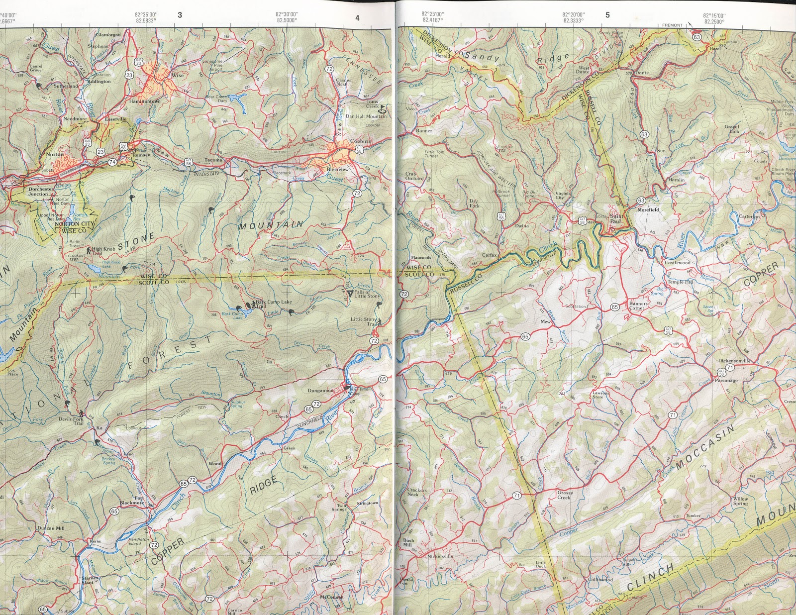
1850s, Wise County was formed out of parts of 3 counties, including Russell. We are interested in the area around Coeburn, Fort
Blackmore, and Castlewood. This is near the local where the three counties,
Scott, Russell, and Wise meet. A map of this region is below.
The Dorsey’s
said:
From here Nathaniel Gist and his family and
others went to the new lands that were being made available in Washington
County, Virginia. Soon after they arrived the Revolutionary War started, and he
and his brothers Richard Gist and Thomas Gist enlisted in Col. William
Campbell’s Regiment of Washington County, Virginia. It is thought that
Nathaniel was killed. The name of Nathaniel Gist appears on the monument of
those killed during the encounter with the British forces at the Battle of
Kings Mountain (L. P. Summers, History of Southwestern Virginia, pp. 859, 164)
(record of the monument on the battlefield).
Children of Nathaniel and Dinah Gist (thought
to have been their children)
i.] Nathaniel Gist 5. On October 14th, 1791,
Nathaniel Gist by warrant entered 800 acres of land lying on the waters of
Holstein River and on the top of White Mountain to have the naked place or old
field in the center and running according to law by quantity . . . (Washington
Co., Va. Record Entry and Surveys, No. 1, p 99). No records have been found of
the sale of this land.
ii.] John Gist 5, may have gone to Tennessee.
iii.] Aaron Gist 5, may have gone to Tennessee.
iv.] George Gist 5, On March 28th, 1796,
George Gist bought 50 acres in the Raccoon Valley on a branch of the North Fork
of Holston River, from James Walsh. On August 9th, 1797, when living in Russell
County, Virginia, he sold this land to William Gilson [Vance’s note: Gibson?]
(Washington County, Va Deeds 2, pp21, 88).
Probably others. [Vance’s note: according to
the Smith’s, they also had a daughter named Mary.. Also Don and I disagree on
this. He places Mary as a daughter of Nathaniel b. 1707, and I think she was a
daughter of Daniel b. 1736; but it is impossible to prove either.
Gist’s Station
An
early Virginia fort was named “Gist’s Station.
At the
above link is a discussion of Virginia’s Seven entitled “FRONTIER FORTS OF SOUTHWEST VIRGINIA”;
By Emory L. Hamilton, which she says comes from “Historical Sketches of
Southwest Virginia,” Number 4, 1968, pages 1 to 26. She lists far more that seven forts. About Fort Blackmore, and Guess’s Station, she
writes;
THE 7
ORIGINAL FORTS
. . .
BLACKMORE'S
FORT
This is the "small fortification"
that Captain Russell wrote Preston was being built at Blackmore’s at the mouth
of Stony Creek, but which in time grew to be the second most important fort on
the frontier. Built on the lands of Captain John Blackmore, who along with his
brother Joseph had come from Fauquier Co., VA, with their families to carve out
homes in the wilderness in the year 1772.
Being more exposed it was attacked by Indians
more often than Moore’s and many people were killed and captured in and around
this fort. The fort stood on the north side of Clinch, just outside the village
of Fort Blackmore. It was to Blackmore’s that all the people came when the
forts in Powell Valley were evacuated in 1776, just prior to the outbreak of
the Cherokee War, as did the people from Rye Cove Fort. It must have been of
large proportions, but no one has left any known description of this fort. According
to Samuel Alley who was born in sight of the fort in the year 1801, it was torn
down and no vestige of it remained in 1887, when he paid a visit to his old
home and found the ground where the old fort stood being tended in corn.
However, nearby stood an apple tree planted by his father which to that day was
known as the "John Alley Apple Tree." (11)
Across the road in a fringe of trees and
brush, and slightly northeast of where the old fort stood is the old fort
graveyard, with rows of small, uncut stones marking the final resting place of
those who died from either the stroke of disease or tomahawk in the long ago.
Always known as Blackmore’s Fort, the village
today, almost two centuries later still bears the name except in the reverse
order of Fort Blackmore.
GUEST
STATION
Of all the frontier stations along the Clinch
this one presents the greatest enigma. The location is between Big and Little
Tom’s Creek, on Guest River at the present site of Coeburn, Wise Co., VA.
Outside of deed references which mention this station frequently no other
direct reference has been found pertaining to it, and no militia correspondence
or pensions applications make mention of it.
Charles B. Coale, in "Wilburn Waters"
tells of the Indians going to this station in 1777, after their capture of Jane
Whittaker and Polly Alley, and finding it well defended make no attack upon it.
Coale gives no authority for this statement and search for it has proven
fruitless. Who built the station and for what purpose is unknown. There are
several opinions, but opinions unless backed by factual data should never
become a part of written history. This writer does categorically deny that it
has any relation with Christopher Gist as has been written, since Gist did not
travel through the present bounds of Wise County.
Elder Morgan T. Lipps, who settled on Tom’s
Creek in the spring of 1838, states in his diary:
That the old settlers showed him some of the
logs of the old fort and chimney rocks still lying upon the ground when he
arrived there in 1838. Even if Christopher Gist did visit this spot in 1750, he
could never, with the help of a small Negro boy, have built a structure whose
remains would have lasted 88 years after his departure.
That some sort of fortification existed at
Coeburn is unquestioned, since from the earliest times the place was called
Guesses Station, and retained that name until the coming of the railroads when
the name was changed.
Nathaniel
Gist and Cassels/Castle’s Woods
http://www.rootsweb.ancestry.com/~varussel/landgrants/washcosurvbk.html
Page 192 - John Dickerson...286
ac...Commissioners Certificate...on the north side of Clynch River...Beginning
on the bank of Clynch River below Gists Ford...corner to Henry Dickerson...on
John Barsdales line...by a path...March 15, 1783 - John Dickerson, heir of
Humphrey Dickerson, assignee of Joseph Blackamore, assignee of Nathaniel
Gist...310 ac on the north side of Clynch River in Cassels Woods, includes
improvements...surveyed on May 28, 1774, actual settlement made in
1769...August 23, 1781.
So . . . Remember John and his brother Joseph
came to Southwestern Virginia and they built Fort Blackmore. Joseph was
assignee of Nathaniel, the same Nathaniel mentioned by the Dorsey’s, implying
the Gist’s and Blackmore’s knew each other. This also tells us where Nathaniel’s
original place was located – the North side of Clynch River near Cassel’s
woods. It says the original settlement was made in 1769. SO although our
Nathaniel was in Cumberland County, North Carolina, he also had a place near
the border of 3 present day counties – Wise, Russell, and Scott. Also notice
the copy of that old map as well as a modern map to find the locations Coeburn,
which was originally named Gist’s Station, Wise County, Va.; Cassel’s/Castle’s Wood, on the south side of
Clinch River (Nathaniel was on the North side of the river), and Fort
Blackmore, in Northern Scott County.
Lewis
Jarvis
There is an article that can be found all over
the internet with respect to the Melungeons. Just type his name in any search
engine and you can recover his entire statement. I have recovered only those
parts that mention Fort Blackmore.
The white emigrants with the friendly Indians erected a fort on the bank of the
river and called it Fort Blackmore
and here yet many of these friendly “Indians” live in the mountains of Stony
Creek, but they have married among the whites until the race has almost become
extinct. A few of the half-bloods may be
found - none darker - but they still retain the name of Collins and Gibson,
&c. From here they came to Newman’s ridge and Blackwater and many of them
are here yet; but the amalgamations of the whites and Indians has about washed
the red tawny from their appearance, the white faces predominating, so now you
scarcely find one of the original Indians; a few half-bloods and
quarter-bloods-balance white or past the third generation.
The old
pure blood were finer featured, straight and erect in form, more so than the
whites and when mixed with whites made beautiful women and the men very fair
looking men. These Indians came to Newman’s Ridge and Blackwater.
Jarvis
also wrote ;
These people, not any of them, were here at
the time the first white hunting party came from Virginia and North Carolina in
the year 1761...Vardy Collins, Shepherd Gibson, Benjamin Collins, Solomon
Collins, Paul Bunch and the Goodmans, chiefs and the rest of them settled here
about the year 1804, possibly about the year 1795, but all these men above
named, who are called Melungeons, obtained land grants and muniments of title
to the land they settled on and they were the
very first and came here simultaneous with the white people not earlier
than 1795. They had lost their language and spoke the English very well. They
originally were the friendly Indians who came with the whites as they moved
west.
Remember
it says they had lost their own language – some Catawba had lost their
language, but the Cherokee hadn’t. AT this time in history very few of the
Cherokee could even speak English.
Recall
Ms. Hamilton writing about Virginia’s Southwester Fort’s, she mentioned Charles
B. Coale, in "Wilburn Waters" with regards to Gist’s Fort/Station,
found in chapter 29. This entire book can be found here
http://www.newrivernotes.com/topical_history_books_waters_wilburn.htm#c28
I have
found the references I question. Here is what Coale wrote:
[p. 173] The Indians, finding that they had
been discovered, and that they were. not strong enough to attack or besige the
fort, started in the direction of Castle's Woods. The persons at Bluegrass
knowing that the settlement at Castle's Woods was not aware that the Indians
were in the vicinity, determined to warn them, but the difficulty was how this
was to be done, and who would be bold enough to undertake it, as the Indians
were between the two forts. When a volunteer for the perilous expedition was
called for, Matthew Gray, who but an hour before had made such a narrow escape,
boldly offered his services, and, getting the fastest horse and two rifles,
started out through almost unbroken forest. Moving cautiously along the trail,
he came near Ivy spring, about two miles from the fort, when he saw signs which
satisfied him that the Indians had halted at the spring. There was no way to
flank them, and he must make a perilous dash or fail in his mission of mercy.
Being an old Indian fighter, he knew that they seldom put out pickets. The
trail making a short curve near the spring, he at once formed the plan of
riding quietly up to the curve, and then, with a shot and yell, to dash through
them. This he did, and before they had sufficiently recovered from their
surprise to give him a parting volley, he was out of reach. He arrived at the
settlement in safety, and thus in all probability saved the lives of all the
settlers. The Indians, however, captured two women on the way--Polly Alley at
Osborn's Ford, as they went up the river, and Jane Whitaker near Castle's
Woods.
Finding the fort at Castle's Woods fully
prepared for their reception, the band had to abandon their murderous purpose
and pass on with their captives, without permitting themselves to be seen.
Reaching Guess' Station, they remained part of the night, but finding it
well prepared for defense, they continued their journey to the
"Breaks," where the Russell and Pound forks of Big Sandy pass through
the Cumberland mountain. Here, tradition says the tarried half a day, and
loaded themselves with silver ore. This tradition has led some to suppose that
this was the place where Sol Mullins, the noted maker of spurious coin,
obtained his metal, as he long inhabited that region.
Coale
also says the following about Waters, at the end of chapter 1;
Wilburn is one-fourth Indian--what is called a
quarteroon. For some reason he has never given, except his fondness for
solitude and hunting, he sought and settled the obscure spot in which he has
resided so many years, and still thinks he would be crowded to suffocation were
a family to settle within sight or hearing of him. The writer of this, soon
after hearing of the hermit-hunter, now more than twenty-five years ago, found
his way into the mountains and sought him out. When he found him, he was eating
his morning meal upon a log,--which consisted a corn cake, bear-meat and wild
honey, and water from the spring--his two savage bear-dogs meanwhile standing
sentinel, awaiting his word for action. We broke bread together, and from that
day to this, if the writer has a friend upon whom he could rely in any emergency,
that friend is Wilburn Waters, the great hermit-hunter of White Top Mountain.
Coale
starts chapter 2 by saying;
Chapter II
BIRTH, PARENTAGE, NATIVITY AND EARLY ORPHANAGE
OF WILBURN WATERS
Wilburn Waters was born on what is called Ready's
River, a branch of the Yadkin, in Wilkes county, North Carolina, on the 20th
day of November, 1812. From the best information that can now be had, his
father, John P. Waters, was a French Huguenot, who emigrated to America in
early life, about the beginning of the present century, and settled in South
Carolina. He was a man of some education and liberal acquirements, of strong
prejudices and passions, restless, reckless and fond of adventure. Being
remarkably stout, fearless and passionate, he was considered dangerous when
excited or laboring under a sense of injury, and was supposed by those with
whom he communicated most freely, to have been a refugee from South Carolina,
if not from France, from some cause he never revealed to others. He settled
down, without any apparent calling, among the simple and obscure people on
Ready's River, where, after a time, he married his wife the mother of Wilburn,
who was a half-breed of the Catawba Indian.
So our
Gist’s were in Wise County long before there was a Wise County. We have
discovered some of the builders of Fort Blackmore were Indian (no tribe is
mentioned, except the Catawba), and that Wilburn Waters, the only man who tells
of Gist’s Station from a firsthand account, himself was part Catawba Indian.
There are other records (I haven’t mentioned yet) that speak of the Melungeons
as having mixed-Catawba.
At this
point we have no connection at all with the Cherokee. But our Gist’s might
connect with the Catawba, as some of their neighbors did.
Please
note on the map Gist’s Mountain near Coeburn, Wise County, andGist River running
through the town. Please note the location of Castlewood, about 7 miles away,
as the crow flies, in western Russell County. Also see Fort Blackmore to the
south of Coeburn, and to the west of Castlewood. Our Nathaniel b. 1736 would
have known these places well before his life was cut short at Kings Mountain,
in 1780. There is a Nathaniel Gist shown living there in 1801 and 1802
(probably a son), and then he too disappears.
The maps below help us understand the locations of the various names mentioned in this report.
.jpg)

No comments:
Post a Comment