CHAPTER 1 – EXPLORERS
One
of the most interesting things about the Catawba and Associated Bands
is that their known history goes back to the dawn of written history
in the Americas. Christopher Columbus landed in 1492, and by 1521, a
mere 29 years later, there are records of Spanish Conquestidores
visiting them.
De
Soto's Expedition, 1539-1540
Hudson
speaks of four Spanish expeditions – Panfilo de Narvaez, Hernando
de Soto, Tristan de Luna, and Juan Pardo. These expeditions occurred
between 1521 when a raid for slaves was made on the Chicora coast and
1569 when the Spanish established a settlement at Santa Elena and
hoped to use the Indian farmers labors as a permanent food supply.
The Spanish raided the area for slaves only rarely. Hudson mentions "these slave raids caused some of the Indians to move up river for safety.".
There is a Shakori Band of these hill tribes a little inland that
could correspond to the Chicori mentioned by the Spanish. (1) Hudson speaks of two cultures meeting, believing that as some coastal people moved inland, those already inland fled in two directions, one to the North and a second south to the Santee River. These intruders stayed a century and then left while the original Piedmont people returning. Maybe this was the Tuscarora. He bases this on the ceramics found in both regions. He called the intruding people the "Pedee people". Hudson concludes the Pedee people were physically and culturally different from the Piedmont people. He states that the Piedmont people had longer and narrow heads while what he calls the Pedee people had round heads. What he calls "the Pedee People" also practiced skull deformation, built square or rectangular buildings and built mounds with ceremonial grounds on top. He goes on to say the original Piedmont peoples were more primitive.
At
one time a band of the Yuchi were neighbours of the Catawba. They were
living on the coast, near modern day Savannah, Georgia. They lived on
the Muskogee and Suasion border region. There language has said to
look a little like the Muskogee an and a little like the Catawba. According to maps and writings I've seen, they seem to have lived at times as far inland as Middle Tennessee at times, and as far east as the Atlantic Coast at others.
The
English language also looks like it also has dual origins, part
Germanic and part Latin. Once the Romans conquered the Britons, they
introduced the Latin language. Later they were conquered by the
Germanic Saxons. The Normans, who had been, it was said, Scandinavian
Vikings who were thuc called “Northmen” which was shortened to
“Norman”. But they took the local Latin language which became
modern French, and brought the French language to Britain when they
conquered it in 1066. Oh, and the original Britons, as well as French, were neither Latin nor Germanic at all – they were both a
Celtic speaking people. See how complicated it can get? This tells us
something about the Uchee/Yuchi – they had a complicated History of
interactions with both the Catawba and Creek speaking peoples. Their
language might tell us more about those who once conquered them than
about they themselves. The point of all these findings is that several peoples lived in this region that might have been lost to history and are now forgotten in time. Our best guesses might not reveal actual events.
These
Yuchi that once lived along the coast have a legend telling of
viewing ships on the horizon, that landed on the coast. They returned
a second time and took samples of the soil. They returned a third
time, this time wanting land on which to grow crops. This is the
Yuchi story. So THEY might be the people taken in Spanish slave raids, and not the Shakori. (2)
Returning
to recorded history, we have another tale to tell. The Indians first
saw Spanish ships in 1521. These ships were owned by Vasquez de
Ayllon, and they were on a slave gathering mission. At a place called
Chicora, the Spanish tricked some of the Catawba on board, then took
off with them They went back to the Caribbean where they were sold as
slaves. One of the slave ships sank, and many on the other ship later
died. This could be the Euchee story as seen by Spanish eyes -- there is no way to know.
Sometime between Ayllon's expedition and De Soto's later, they started calling this land “Cofitachique”. Cofitachique is a word of Muskogeean origin. Now the Muskogeean and Catawba peoples were enemies. The Creek peoples held sway over lands from the Mississippi River to Northern Florida, from North of Memphis, Tn to the region around what is now Chattanooga, Tennessee -- a vast region of many tribes, but all speaking similar languages. The Creek/Muskogeean people started telling the Spaniards of a fabled land called Cofitachique which was a land of great wealth. He heard of a place called Yup-aha. Perhaps this was what became Ye-sah/Esaw/Waxhaw? We will never know. On De Soto's route to discover Cofitachique, he came across the Creek/Muskogeean village of Cofaque. The war captain of the city was Patofa. When they knew what De Soto wanted to do, they were eager to join the expedition. The Cofaque brought a great supply of food with them. They were eager to obtain vengeance on Cofitachique, but the Spaniards were ignorant of their ambitions.
Interestingly, Hudson mentions a great buffer between the Creek and Siouann
speakers. He said it took two weeks to pass through this "no man's land" where no people lived. Most American Indian Societies were like this. The people would live in a certain region. Between nations was usually a great "Hinting Grounds" which was used by both nations.There was a great region where no people lived. This is
something many researchers ignore, but has to be understood and
explained in any research of American Indian Peoples. ALL tribes had
a great parcel of land that is called “the hunting grounds” that
remained uninhabited. It was left alone for the livestock, the deer,
the turkey, the bear. That is where the tribal animal herds were
kept. It isn't true that the Indians didn't “own” animals, they
just had a different concept of “ownership” than we do today.
They considered the deer, turkey, and smaller game as theirs, and if
a neighbouring tribe was caught on their hunting grounds, a war often
was the result. Since more than one tribe used the same hunting
grounds, inter-tribal warfare was common.
Finally
De Soto and his Cofaque allies reached a village loyal to
Cofitachique. Immediately the Cofitaque war chief Patofa and his warriors started massacring the
villagers, and the took many scalps. Hudson goes on to say after Patofa had destroyes several other villages they returned to Cofaque. Meanwhile De Soto continued on to Cofitachique (3).
On
May 1, 1540, De Soto's men came to a large river. De Soto remained
there until 13 May, 1540. Cofitachique was ruled by a woman. Despite
being treated with great respect, the Spanish took her as a hostage. Hudson said "The main town of Cofitachequi is thought to have been located at Silver Bluff, near Augusta, Georgia, on the South carolina side of the Savannah River." (4) Blumer said “Today
we know the site of Cofitachique as modern Camden, [South
Carolina].
The Catawba did not abandon its ceremonial center until after the
treaty of Augusta in 1763.” Cofitachequi is a Muscogeean word. Blumer says "In the language of the Catawban speakers who lived there, the place was called Yupaha." (5)
Map (1.) Early Spanish Expeditions

Please notice the location of Chicora. On the previous page (4), Hudson says: . . . another colonial venture was set in motion in 1521 when two ships dropped anchor off the Atlantic coast of the Lower South. One of these ships was owned by Lucas Vasquez de Ayllon, an official of Santo Domingo. The Spaniards went ashore, where they had a friendly encounter with the Indians, some of whom they persuaded to come out and visit their ships. But when the Indians canoed out and climbed aboard, the Spaniards promptly enslaved about sixty of them and sailed for Santo Domingo. (4) One of the ships sank en route, and most of the Indians on the other ships died, but at least one of the Indians on the other ships survived, to be baptized Francisco de Chicora.
The
Spaniards trained one of the Indian slaves to speak Spanish, and
renamed him Francisco de Chicora. Ayllon in 1521, returned to Chicora
with Francisco, hoping to colonize the land. This time when Ayllon
arrives, the Indians who saw his ships arrive fled into the woods.
Francisco did the same, when he got the chance. The Spaniards never
saw him again. This attempt to plant a colony on the Carolina coast
failed. (6)
Francisco
later was taught Spanish, and returned to the Carolina coast with a
future expedition to colonize the lands for the Spanish. Of course he
escaped, went home, and there is no further mention of the Chicora.
But we do have a band of Eastern Suasion later called the Shakora.
Are these the same as Chicora? Perhaps the Chicora fled the coast
after the Spanish enslaved some of their warriors, feeling it was
safer in the interior.
From
viewing later maps, it appears the Chicora fled upstream 150 or 200 miles, where
they are called Shakori by 1650. By 1700, per map 7, they are in
relatively the same location still called Shakori. This appears to contradict other statements saying foreigners moved into the area, as they would not have been foreigners. There is another possibility. They could have been Algonquin (from the coastal tribes of Virginia, a Muscogeean or Iroquayan tribe on good terms with the local Catawban speakers, and asked to move to the interior, and was request was granted.
Map (2.) De Soto's Journey

Above is a map from 'The Juan Pardo Expedition”, Hudson, page 7. It shows the route taken by De Soto, earlier. East and North of the line from Hymahi to Cofitachequi to Xuala to Guasili, we have the Eastern Suasion peoples. To the west of Cofaqui in the south to Chiaha to the north, we have the Muskogeean speaking peoples. The Cherokees will enter later and conquer the northern parts of the Creek (Muskogeean) territory, from Chiaha to Coosa. The word 'Coosa' is of Creek origin – these communities either are not Cherokee, or non-Cherokees provided the Muscogeean names for these Cherokee communities.
There
are some interesting Eastern Siouan towns mentioned by both De Soto
and Pardo. We have Xuala, the origin of the Saura, and Cofitachiqui,
a town that awed the Spaniards. Per Blumer, we now know hte Catawban speakers who lived there called the place "Yupaha". What the Spaniards called Xuala and
later Joara on the map of the Juan Pardo expedition below, turns out
to be one of the main bands of the Eastern Siouan tribes, and is
later called Saura/Cheraw. The Guaquiri/Guateree later move nearer
the Catawba and become known as Wateree. Neither Pardo nor De Soto
mention the Cherokee, but today's “Qualla” lies close to the
“Xualla” of De Soto, or “Joara” of Pardo.
Juan
Pardo's Expeditions,
1566-1568
The
Spanish began an effort to colonize the vast holdings of Cofitachique/Yupaha and allied bands, also called Canos or Canosi until after the founding
of St. Augustine in 1565. It is confusing to determine where places were located as they were called different things by the Spanish, the Muscogeean peoples -- the Virginians and South Carolinians even called the same locations by different names. At different times they also were called by different names.
Pedro Melendez de Aviles was the man behind the Juan Pardo adventure, and he had the backing of the Spanish crown. Part one of this adventure was the defeat of the French in the area. Part two was the founding of Santa Elena on the South Carolina coastline. The third part of his plan was to gather about 120 men under the command of Captain Juan Pardo, and have them march inland. Menendez hoped they'd find an inland road to what is now Mexico. Pardo was also asked to pacify the Indians, and evangelize them so that they would become Catholic Christians, and to bring them under the authority of the Spanish Crown. Pardo's progress was recorded by Juan de la Bandera, Pardo's archivist. Father Sebastian Montero went along with the job of converting the Indians. They travelled through the heart of the Catawba regions. According to Blumer, the names of many of the locations Pardo visited still had similar names as the names recorded by De Soto's men earlier, and those names were of Catawban origin. Father Montero spent several years amongst the Wateree (called by the Spaniards Guateri) and he had some success in converting them to Catholicism A report exists where some Indians learned Spanish, and they even learned several Catholic prayers. (7) Father Montero lived amongst the Catawban peoples until 1572. His health failed him and he returned to Spain. The Spanish crown did not see to it that he was replaced, and his mission was abandoned.
Pedro Melendez de Aviles was the man behind the Juan Pardo adventure, and he had the backing of the Spanish crown. Part one of this adventure was the defeat of the French in the area. Part two was the founding of Santa Elena on the South Carolina coastline. The third part of his plan was to gather about 120 men under the command of Captain Juan Pardo, and have them march inland. Menendez hoped they'd find an inland road to what is now Mexico. Pardo was also asked to pacify the Indians, and evangelize them so that they would become Catholic Christians, and to bring them under the authority of the Spanish Crown. Pardo's progress was recorded by Juan de la Bandera, Pardo's archivist. Father Sebastian Montero went along with the job of converting the Indians. They travelled through the heart of the Catawba regions. According to Blumer, the names of many of the locations Pardo visited still had similar names as the names recorded by De Soto's men earlier, and those names were of Catawban origin. Father Montero spent several years amongst the Wateree (called by the Spaniards Guateri) and he had some success in converting them to Catholicism A report exists where some Indians learned Spanish, and they even learned several Catholic prayers. (7) Father Montero lived amongst the Catawban peoples until 1572. His health failed him and he returned to Spain. The Spanish crown did not see to it that he was replaced, and his mission was abandoned.
Please
note that as you read, you see that Pardo and his men were NEVER
lost. Also note they were NOT Portuguese, but rather Spanish. Would a
19th century
Caucasian man of Scottish ancestry report
that his ancestors in the 17th century were English? NO! He'd report they were Scotsmen! And the Spanish were no different. They were as proud of their heritage as any of us would be. As we see, there were trade routes, paths and roads that went to and from all the Catawban and Eastern Suasion towns. There is no way a group of Pardo's men could have gotten lost. Had they offended the Indian peoples seriously enough they would have been killed. Had they gotten homesick they would have returned to Florida, where they would have run into their own kindred. Had they committed a crime against Spain and fled to the Indians for protection and if they succeeded in getting that protection (a big "if") they would have adapted the Indian culture, and in a couple of generations that Spanish heritage would have been just a vague memory. But Moyano's men KNEW the roads back to Spanish settlements of Santa Elena and Saint Augustine very well. Here (below) is a map of Pardo's route. Some of Pardo's men remained in the interior and these are the men some say were the unfortunate ones, those left behind, under the command of Sergeant Moyano. But notice the movements of Moyano's men in the interior IS KNOWN! They were NEVER lost in the interior! How could his movements have been known if he disappeared? To those interested in correcting Melungeon History -- some say Moyano's men were lost in the woods and show up again 2 or 3 hundred years later as the Melungeons. This could NEVER have happened. It makes no sense. Moyano's men built a small fort near Joara (earlier called Xuala, and later to be known as Saura). The smaller dotted line on the map is a raid Sergeant Moyano and his allies made over the mountains on the neighboring community of “Olimico”. The end of that name, “mico”, suggests a Muscogeean origin. However the Spanish might have used a Muscogeean translator, and he would have given the community a Muscogeean name. It is difficult to speak in absolutes when dealing with some issues that we will come across, from time to time.
that his ancestors in the 17th century were English? NO! He'd report they were Scotsmen! And the Spanish were no different. They were as proud of their heritage as any of us would be. As we see, there were trade routes, paths and roads that went to and from all the Catawban and Eastern Suasion towns. There is no way a group of Pardo's men could have gotten lost. Had they offended the Indian peoples seriously enough they would have been killed. Had they gotten homesick they would have returned to Florida, where they would have run into their own kindred. Had they committed a crime against Spain and fled to the Indians for protection and if they succeeded in getting that protection (a big "if") they would have adapted the Indian culture, and in a couple of generations that Spanish heritage would have been just a vague memory. But Moyano's men KNEW the roads back to Spanish settlements of Santa Elena and Saint Augustine very well. Here (below) is a map of Pardo's route. Some of Pardo's men remained in the interior and these are the men some say were the unfortunate ones, those left behind, under the command of Sergeant Moyano. But notice the movements of Moyano's men in the interior IS KNOWN! They were NEVER lost in the interior! How could his movements have been known if he disappeared? To those interested in correcting Melungeon History -- some say Moyano's men were lost in the woods and show up again 2 or 3 hundred years later as the Melungeons. This could NEVER have happened. It makes no sense. Moyano's men built a small fort near Joara (earlier called Xuala, and later to be known as Saura). The smaller dotted line on the map is a raid Sergeant Moyano and his allies made over the mountains on the neighboring community of “Olimico”. The end of that name, “mico”, suggests a Muscogeean origin. However the Spanish might have used a Muscogeean translator, and he would have given the community a Muscogeean name. It is difficult to speak in absolutes when dealing with some issues that we will come across, from time to time.
Map 3. Juan
Pardo's First Expedition and Sergeant Moyano's Raid

The English called these people Saura, which later became Cheraw. Pardo only went as far as just beyond Juara. Moyano made the advance further to the west to Olamico.
Juan
Pardo departed December 1566 and returned March 7, 1567. He left a
handful of soldiers under the command of Sergeant Moyano. The map
shows the route of their expedition against the neighboring Indians
in the spring of 1567. These men did help the people of Joara attack
a few communities in the mountains. The
following is taken from "The Juan Pardo Expeditions" by
Charles Hudson. Hudson states, "The
next place they came to was Joara, a very important town near resent
day Marion, North Carolina. at the foot of the Blue Ridge Mountains .
. . this was the same town De Soto chroniclers called Xuala." (8) Hudson goes on to say Pardo remained at Joara two weeks, and when he
left, he left about 30 men at a Fort they called “San Juan at
Joara”. This small fort has recently been found. I will discuss it
shortly under the command of Sergeant Hernando Moyano. It goes on to
say he provisioned them with supplies for their matchlock guns.
Please note that according to Hudson, Pardo returned to Santa Elena,
in part, by a different route than he had taken, and that he had no
problem at all getting back to their Spanish base at Santa Elena on
March 7, 1567.
Sergeant
Moyano, They Left No Man Behind
Per
Hudson, "Sergeant
Moyano did not see Pardo again for about nine months, although the
two of them exchanged letters carried by messengers.".
Does this sound like they got lost and forgotten by the Spaniards?
No, it doesn't. In early April, Pardo received a letter from Moyano
saying they had fought a battle against the 'Chicsa' Indians. Could
that be the 'Chickasaws'? Hudson guesses at the location of the
Chicsa town and says Moyano attacked it with 15 men, but he says the
exact location is unknown. The next part is very important, as to the
conspiracy that these Spanish men were lost, and later became the
forefathers of the Melungeons. The following is proof this did NOT
happen. Hudson writes, "When Juan de Ribas, one of Pardo's
soldiers, was questioned in 1602, he said that Moyano had helped an
Indian chief defeat a rival. To have known this, Ribas must have been
one of Moyano's men, and he was living with the Spanish in 1602, and
was NOT lost in the Southern Appalachians.
Hudson provides one more such proof in the next paragraph. He states, "Moyano's involvement in aiding one interior chief against another is confirmed by Jaime Martinez, who served as an accountant in Florida from 1571 to about 1579. During this time, Moyano told Martinez about his exploits . . ." (9). So Moyano DID REAPPEAR in Spanish Florida! If the leader of the expedition reappeared in Florida, presumably so did his men. There is no reason to assume otherwise. These Spaniards that Pardo left behind returned to Spanish dominions.
Moyano's men would have run out of ammunition and they would have had to have been resupplied. But there were roads, trails, often called traces, that went from the interior, going through the lands of the Eastern Suasion peoples, back to where the Spanish lands were, and the Spanish town of Santa Elena. Even without trails, they could have just traveled down the river, with the flow of the river taking them back to the Atlantic Ocean. We know they helped the Indians fight their enemy in the Mountains, so they should have been on friendly terms. Had that changed, the Indians would have killed them. And remember, Monayo and his men were Spanish, not Portuguese!
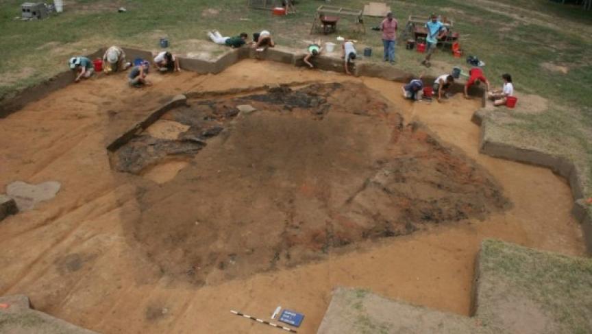
There is mention of this Spanish fortress of “San Juan”, in Western North Carolina, as having recently discovered by archaeologists.
Sergeant Moyano's Fort Found in Great Smoky Mountains
The
photo below shows archaeologists studying a ceremonial mound in a
Native American town called “Joara” discovered an inland fort
built by a Spanish expedition in the New World near present-day
Morganton, North Carolina. Source: University of Michigan
archaeology.
The Spanish explored North America in the 1500s, looking for a way overland to get to the silver mines in northern Mexico. Expeditions led by Juan Pardo headed west from North Carolina from 1566 to 1568. The pilgrims wouldn’t arrive for decades, so North America was wide open to be claimed by the Spanish.
During those times, they built a fort near what is now Morganton, North Carolina. Archaeologists have recently discovered its remains.
Robin Beck is a University of Michigan archaeologist who works on the team that discovered the fort. He says that the Spanish expeditions were the apex of Spanish involvement in the New World. They failed for two reasons – food and sex.
The Spanish needed the Native Americans for their food supply. It didn’t take long, though, for the Spanish to start treating the Native Americans as their subjects. The Spanish also became involved with the Native American women, relationships that soured and sowed mistrust. The conflict that grew from this brought the end of the Spanish expeditions.
Their claim on the American interior failed. This gave an opening to the English settlers to establish outposts in early America. (17)
Photo
1.
I
sus-pect they could have gone with the Indias on huntig expe-ditions
and proven their man-hood to the Indias.
There were also plenty of Indian women. I don't think “food and sex” is a very good explanation as to just why the Spanish failed. I think it boils down to a lack of Spanish manpower. They needed more Spaniards than they were willing to spare. To create this colony. Had they brought in more Spanish settlers, history might have been different.
There were also plenty of Indian women. I don't think “food and sex” is a very good explanation as to just why the Spanish failed. I think it boils down to a lack of Spanish manpower. They needed more Spaniards than they were willing to spare. To create this colony. Had they brought in more Spanish settlers, history might have been different.
Below is another map found in 'The Expeditions of Juan Pardo, Hudson'. Many towns listed are from the Spanish era, but the rivers were named later. The caption to the map below is self explanatory. The towns on the far western and far southern parts of the above map are Creek/Muscogeean in origin. Something to ponder – most of both the Suasion and Muscogeean towns the Spaniards listed had disappeared before English chroniclers rediscovered them. What happened to them? Be thinking about that.
Guatari is also of interest. In Spanish, 'Gua' is pronounced as the English 'wa', and the Spanish 'i' is pronounced like the English long 'e'. So Guateri should be pronounced 'Wa-ta-ree'. Map 13 also shows the movements of the Guateri/Wateree from/to 1670 when they flee to live near the Catawba,where they remained until they vanished. There is also the town of “Otari” which would
have sounded very similar.
Also notice the towns of Yssa and Yssa the lesser. This is identical to Esaw, Issa, Iswa, Yesa, Yesah, and perhaps more spellings can be found. The Yssa and the Catawba are the same people. Esaws are shown on maps 7 and 9. Map 10 show the Esaw between the Catawba and Waxhaw. This map dates to about 1715, after the Tuscarora War, yet before the Yamassee War.
Notice Gueca. It is almost straight south of Guateri. Is Gueca, with the 'c' having a mark under it. This would be pronounced sort of like an 's' sound. The Spanish 'e' is pronounced like the English long 'a' sound. Remember “Gu' is pronounced like a 'w'. So 'Guaca' would be pronounced something similar to 'Wa-sa'. Later in the same location we will find the Waxhaw Indian town. Likewise, Guiomae might be pronounced Wimae.
One last point of note is that there is NO “Catawba” on the Spanish maps.
Map
4. Towns mentioned on Juan Pardo's Second Expedition

Many
of these bands of Eastern Suasion Indians did not move for a hundred
or more years, while others did. It appears as though those moving,
were escaping some threat. The Northern bands as we shall see later,
fled , some eastwards to receive the protection from the English.
Others fled to be nearer the main body of the Catawba for the same
reason. At some point the Cherokee moved into the region of Western
North Carolina, if they were not already there.
This movement by the Cherokee seems to be one reason the Saura fled eastward. What if these Northern and Western Bands of Catawbans were attacked by the Cherokee? Sergeant Moyano's attack on their neighbours to the West might have been one small battle in a larger warfare. Something caused the Western and Northern bands of Eastern Suasion peoples to abandon their lands and move east and south. But the Cherokee did not have rifles yet, and those attacks came from Indians with muskets. We might have to keep looking.
This movement by the Cherokee seems to be one reason the Saura fled eastward. What if these Northern and Western Bands of Catawbans were attacked by the Cherokee? Sergeant Moyano's attack on their neighbours to the West might have been one small battle in a larger warfare. Something caused the Western and Northern bands of Eastern Suasion peoples to abandon their lands and move east and south. But the Cherokee did not have rifles yet, and those attacks came from Indians with muskets. We might have to keep looking.
By March 1568 Pardo's work was finished. In 1572 Father Montero left the Wateree/Guateri. His mission was abandoned. (10). The Spanish failed in their attempt to turn the Catawba and the bands of Indians associated with them into Spanish Colony. They were still a strong Indian Nation in the 1570's. By the 1720s they were a rag-tag remnant of a greater nation. What changed in the years between 1570-1630s? Blumer's book just cuts to the Tuscarora wars of 1711-1713. Let us see what we can find.
Abraham
Wood
Abraham
Wood was the earliest if least known of the Virginia Explorers. (11)
The author of this book writes about the earliest explorers of
Virginia. In doing so he speaks of the Indians they find as well. In
the interior of Virginia we find the Monacan and Saponi as well as
others. These are the northernmost bands of the Eastern Siouan
peoples, which I will try to call “bands” of the Catawban peoples
in the future. The author states, “Smith
and Newport in the spring of 1607 and again in the autumn
of 1608 passed beyond the falls of the James, and on the second trip
reached the Monacan [Manakin] town, some thirty miles above the
falls." Other adventurers may in very early times have made
their way
some little distance above the head of tide on the rivers.”
Of course the Jamestown settlers were living amongst the Pamunkey Indians. But the year after the Jamestown settlement was founded, they came across a Siouan speaking people, the Monacan band.
No
new explorations are mentioned for a couple of decades. Then in 1641
four men (their names are not stated) petiton the government of
Virginia for permission to explore to the Southwest of the Appamottax
River. In March the legislature passed a law telling them the
government wanted a cut of anything they found. There is no more said
about this would be expedition. The Indians rebelled in 1644. In 1645
and 1646 several forts are established.
These forts were expensive to maintain, so they were run by private individuals. One of them became known as “Fort Henry”. It was maintained by Abraham Wood. The location of Fort Henry is at what is the city of Petersburg today. Cadwalader Jones was the administrator of the fort that grew into the modern city of Richmond. The Byrd family are aslo associated with this fort. A considerable trade was conducted with the Indians from these locations. The author writes;
“From it went out the Occoneechee or Trading Path southward to the Catawbas and beyond, and also the trail leading westward to the headwaters of the Roanoke and oyer the mountains to the New River – the two great roads of early trade and settlement, both of them first explored by Abraham Wood and his associates. Wood sent out several expeditions from his fort further into the interior. just across the river was situated the principal village or "town" of the Appomattox Indians, who furnished Wood with messengers, hunters, porters, and courageous and faithful guides. At its warehouses were fitted out the pack-trains of the Indian traders. Sometimes these traders were the senrants or paid agents of Wood or of his associates, sometimes they were free traders, "of substance and reputation," who received goods on credit, and contracted to pay for them at a stipulated price. Wood imported from England the varied articles of barter, chiefly Guns, Powder, Shot, Hatdiets (whidi the Indians call Tomahawks), Kettles, red and blue Planes, Duffields, Stroudwatier blankets, and some Cutlery Wares, Brass Rings and other Trinkets. These Wares are made up into Packs and Carryed upon Horses, each Load being from one hundred, fifty to two hundred Pounds, with which they are able to travel about twenty miles a day, if Forage happen to be plentiful" In the early days, before the competition of Charleston began to be felt, the pack-trains might count a hundred horses. Guided by only fifteen or sixteen men they filed oft with tinkling bells southward along the Occoneechee path to visit the Indians of the South Carolina and Georgia Piedmont, or even to swing around the end of the Appalachian mountains and track northward again to the Cherokee. Chiefs of distant tribes, like the "king of the Cherokee, came in with their followers to trade and treat with Wood and received suitable entertainment; though rival traders and the Indians of the nearer tribes, anxious to retain their position as middlemen, tried by force or fraud to intercept them and frequently succeeded. “
Comment: I'd like to comment on this just a little. I have an ancestor who died in 1806, having been born in 1754, a hundred years after these events. All of his belongings were written down when he died, and one of those belongings was listed as a “homahawk”. I would give anything to have seen that “tomahawk” – but but I am a fifth of a millinia too late.
This article also mentions the Appamattox Indians on the opposite side of the River. Abraham Wood used them as guides on his explorations. We also hear the Occoneechi wanted to be used as “middlemen” How will that play out? We will hear of this again.
We might also be hearing of the Cherokee. An early word used for the Cherokee could have been “Tomahittans”. Until now I was sceptical of this.After reading this account I thought this a good possibility. Then I read the wikipedia article found here -- https://en.wikipedia.org/wiki/Tomahittan which makes the claim that the Tomahittan are the Nottawago, or Nottaway. I will make no claim either way.
Back
to the narrative:
Abraham
is first mentioned as an indentured servant boy in Virginia in the
1620s. In 1646 is is mentioned as a Captain of Militia. In 1652 he is
a Lieutenant Colonet, and in 1655 he is a full Colonel. Later he is
called General Wood. For someone who as a child, was recorded as an
indetntured servant in Jamestown before Jamestown was even 20 years
old, he came a long way. But that also means he saw the end of the
Powhattan Confederacy. He saw Indian peoples being enslaved all
around him, and he rose to prominence in that environment. It doesn't
say he was guilty or innocent of these barbarisms, either way.
In 1650 Wood and others travelled through the Tuscarora Nation.
There are stories that in 1654 he and some of his men travelled as far as the Mississippi River. This narrative reads;
“Cropping out in all the literature of Mississippi Valley exploration, from the eighteenth century to the monographs of contemporary scholars, is the bare statement, now calmly presented as a fact, now contemptuously mentioned as a lie, that in the year 1654, or at various times in the decade following that year,
“Abraham Wood gained the banks of the Ohio, or of the Mississippi, or of both. It can probably never be either proved or disproved with absolute certainty, but long and patient search has yielded the facts about to be recited, and only these. They are trustworthy as far as they go, and in spite of meagreness appear to warrant the statement in categorical form of the conclusions drawn from them.
“Dr. Daniel Coxe, whose career will be dealt with later,*' was the first to mention the episode. His account appears in a memorial to King William, presented to the Board of Trade Nov. 16, 1699, and in the younger Coxe's book CarolanaJ^ Coxe states that at several times during the decade 1654- 1664 Wood discovered "several branches of the great rivers Ohio and Mcschacebe." In confirmation, Coxe alleges that he was at one time in possession of a journal of a Mr. Needham, one of the agents Wood em- ployed in his exploring expeditions. Now Wood's men did discover branches of the Ohio and Mississippi, in the years 1671-1674; and the Needham referred to was employed in the most brilliant of those discoveries. Since Coxe states incorrectly both Wood's title and place of residence,^* it is most probable that his information about the date was also incorrect. One of Coxe's later memorials to the Board of Trade, which constitutes the last chapter of this volume, omits all mention of the episode. “
It was said they went up the Dan River through the Mountains, then down the New River. When Batts and Fallam went through this region in 1671 they noted some trees had been “notched”, this showed some White men had proceeded them. If it wasn't Wood and his men, then someone else had passed that way. In 1671 Thomas Batts and Rober Fallam are said to have passed through to the western side of the Blue Ridge Mountains. They also were sent by Wood to explore the region.
This record says;
"It consisted of Captain Thomas Batts, a successful
colonist of good English family, and two other gentlemen, Thomas
Wood, perhaps a kinsman of Abraham Wood, and Robert Fallam. They were
accompanied by a former indentured servant and Perecute, an
Appomattox chief, whose faithfulness and iron
courage should have preserved his name." There is mention of an
“Ha-na-ha-skie” town in the vicinity of the Tutelo and Saponi. It
has the same number of syllables as O-co-nee-chi. Maybe it is one of
those towns that just vanished from historical accounts.
On September 19th, 1671 the Batts/Fallam expedition was said to have seen William Byrd's expedition with “a great company” in the Western regions of Virginia. Was this him returning from a slave raid? They did not write down a great deal about their slave raids. I don't think they wanted posterity to realize just exactly they were doing. It appears that Batts and Fallum made it to southwestern Virginia and returned to Fort Henry. This journey cleared the way for another expedition to go a little further west, and discover the Cherokee.
Needham
We
have Henry Needham going to South Carolina on September 22nd,
1671. The article says he travelled with Henry Woodward. In Allan
Gallay's book about the Indian Slave trade it mentions Woodward as
having been one of the bigger Indian slave traders. Needham would
have known this.
Perhaps
the Occoneechi did as well. About the Occonechi; “Few
in number but
fierce and treacherous, they were strongly fortified on their island
in the Roanoke River at the modern Clarksville, Virginia, just below
the confluence of the Dan and Staunton; and recruiting their numbers
from vagabonds and fragments of various tribes, they exercised a
great influence on the neighboring peoples and were a great hindrance
to the white advance into the
interior.
Why would they be made up of “fragments” of tribes” unless those “tribes” were no longer “whole”? When I read about Needham's death, we are meant to feel sorry fo him. But he was apparently friendly with Henry Woodward, a large well known dealer in Indian slaves. In fact Gallay says (p. 55, “The Indian Slave Trade”) “[Henry] Woodward learned that the Cherokee were the Westo's Enemies, and if the Cherokee were obtaining goods from Virginians, it would have been expedient for the Westos to procure goods from the Carolinians.. The Westo could ill afford an alliance between the Cherokee and the Virginians.” There is more going on here, in the murder of Needham. We are a bout to discuss his murder, but I am convinced that there is more going on here than is usually mentioned.
Back to the narative:
“About
the twenty-fifth of June they
met a band of Tomahitan, who seem to be identical with the Mohetan
and the Cherokee, on their way from the mountains to the Occaneechi
village. Despite the machinations of the Occaneechi, who were
naturally angry at the loss of their position as go-betweens in the
trade, eleven of the Cherokee pushed through to Wood's plantation,
and then overtook Needham with the main band on the way to the
Cherokee country, and effected an exchange of letters. Nine days the
party traveled southwest from the Occaneechi village, crossing nine
eastward-flowing rivers and creeks, to Sitteree, the last village
before reaching the Cherokee country, and doubtless on the headwaters
of the Yadkin. There they left the trail and struck due west over the
great North Carolina Blue Ridge. Four days of hard going, when they
had sometimes to lead their horses, brought them to its narrow
crest. at the end of fifteen days from Sitteree were on the banks of
a westward-flowing
river -the home of their Cherokee friends.”
Remember
history records the Oconeechi killed Needham because of their loss of
status as “middlemen”.
“After a short rest, Needham determined to return to Fort Henry, in company with a dozen Cherokee, and to leave Arthur behind to learn the language. On the tenth of September he reached home, made hurried preparations for another journey, and within ten days had turned his face again toward the mountains. His intention was to make only a short visit to the Cherokee and bring Arthur back with him in the spring. Naturally Wood had been greatly elated at the success of the expedition and had high hopes of the future. He eagerly followed Needham's westward journey, as news of his progress was brought to him, and heard that his agent had safely passed the Eno village and all seemed well. On the twenty-seventh of January, 1674, however, a flying report reached him that his men had been murdered by the Cherokee in their country. Then rumors of the disaster followed each other faster and faster, but the facts were difficult to learn, for the Indians were, as always, fearful of telling the exact truth. Wood dispatched a runner to make inquiries; but before his return, one Henry Hatcher, an independent trader, friendly to Wood and well acquainted with the Carolina Piedmont, arrived and notified Wood that Needham had certainly been killed, and identified the murderer.”
comment: Henry Hatcher, the man who notified Wood of Needham's death, was a man “familiar with the Carolina Piedmont.”
narative: From eye-witnesses Wood later heard the story in all its details. With Needham was an Occaneechi, Indian John or Hasecoll by name, a precious scoundrel who had gone on the first expedition and been suitably rewarded, and retained by Wood to go on the return trip and escort the party safely past his dangerous friends. It was the trader Hatcher, however, who persuaded the Occaneechi to let them pass, and even then several warriors accompanied the explorer, doubtless, as Wood suggested, to see the murder. Near the mountains the treacherous protector became threatening; but Needham maintained a fearless and defiant attitude, his only hope of safety. That evening at their bivouac at the ford of the Yadkin, the treacherous Hasecoll shot the Englishman through the head, before he could draw sword or the Cherokee spring to his rescue. Ripping open Needham's body, he tore out the heart and held it up in his hand, and with face turned eastward bade defiance to the whole English nation. He then commanded the frightened Cherokee to go home and kill Arthur, looted the pack-train to his satisfaction, and made off with the booty loaded on Needham's horse.
Comment: The way Needham was killed sounds like some kind of ritual, similar to something we read about from Spanish chroniclers about the Aztecs or Mayan peoples. Personally, I suspect Needham himself was a slave trader. Whne it says he turned east, he wasn't tying to face the English, he turned to face the direction of the rising sun. Now the death seems more personal. To the South Carolinian officials and to Woodward, it was pure business that Virginia and the Cherokee not trade with one another. But to Hasecoll, it seems more of a personal nature that Needham needed to die. Oh, there sure seems to be far more to this story than we will ever know. It is as though we have the copy of a book with half its pages missing.
It is easy to forget that although these Occoneechi and other costal bands lived amongst the English to a degree, they were NOT European. We forget sometimes that our own European Catholics and Protestants were buring one another alive as heretics, at the same time. Before we judge others, remember the English thought that it was impossible for a “commoner” to tell the truth unless he/she had been tortured. Remember Byrd who killed several warriors who had surrendered so he could sell their families, their wifes and children, and make a profit off of them. ALL PEOPLE in the past it seems, were pretty brutal. Something to ponder.
Needham and Arthur started together, and we only have looked into Needham's fate. What of Arthur?
Arthur
The
dazed Cherokee, after the murder of Needham, hurried home and
reported what had occurred. The chief of the village was away so that
the party friendly to the Occanecchi was, for a moment, in the
ascendency. They seized Gabriel Arthur, bound him to a stake, and
heaped dry reeds about him. In spite of the protests of some of the
Indians, it seemed that another life was to be sacrificed on the
altar of exploration. At the critical moment, the chief, ;gun on
shoulder, entered the village; and, hearing the commotion, ran to the
rescue. An adopted member of the tribe, angered at this interference,
defiantly grasped a torch and started to light the pyre; but the war
chief shot him dead, cut Arthur loose with his own hands, and led him
to his lodge.
Comment: Once the Cherokee heard that Needham was dead by the hands of the Occoneechi, apparently some of them had Occoneechi friends, and wanted to kill Arthur as well. They were going to burn him alive at the stake. Remember Arthur agreed to stay with the Cherokee so he could learn their language and customs, thus become a good go-between. Remember the Occoneechi also wanted to be the go-between. A chief arrived at the scene and saw what was happening and wanted it stopped. An ADOPTED Cherokee started to kill Arthur anyhow, and this chief shot and killed him.
He is about to go on a journey he probably never forgot.
After the Chief saved Arthur's life, he went on several Cherokee War parties against other tribes. He went down to Florida and even against South Carolina settlers, and against the Shawnee. They captured him, realized he was a White man, and sent him back to the Cherokee. Eventually he made it back to Fort Henry with many stories about the interior country, and tribes to be encountered there.
Occoneechi
Hudson
mentioned some of these events as well. Arthur could not return to
Fort Henry using the same route as he did when he left Fort Henry
earlier. He returned to the Sara village, and hired four Sara Indians
to travel with him. They would accompany him only as far as Eno Town,
for fear of the Occoneechi's. Apparently Col. Wood went to visit the
Tomahittan's and they returned to Fort Henry, but went by an indirect
route through Tutelo Town and then to Monacan Town. From there to
Fort Henry, skirting north of the Occoneechi's. As a result of these
events, Per Hudson, Wood says of the Occaneechi;“.
. .they are but a handful of people, beside what vagabonds repaire to
them, it being a receptacle for rogues.” (12) I suspect here is an example of the fact that some tribes simply
vanished. Maybe a few survivors of a now extinct band sought to unite
again with a band still in existence. When he says “vagabonds
repair to them”, he is really saying “a few survivors escaped a
slave raid.“
John
Lederer's Journey's
Early
English explorer's also opened the door to later colonization. John
Lederer, John Lawson, Needham, Abraham Wood, and William Byrd were
amongst these. I hope to talk a little about them as well. We only
have a little in the form of historical documentation to go on
concerning the Saponi. If we had information from multiple sources,
we would have more confidence it the information gleaned from them.
Unfortunately we don't, so remember, one person might have a personal
bias, or a lack of cultural knowledge to draw from, in deriving
conclusions. Please notice the “Rickohockans west of the
Appalachian Mountains, and the Savannah Indians (better known as the
Shawnee). to the east of them. The Rickohockens are shown near where
the Cherokee later appear. Are they one and the same? I sincerely
doubt it, but others disagree.
John Lederer made three journies though Saponi country in the 1670s, and left a record of those travels. Below is a portion of that record. (13)
From
march 1669 until September 1670 John Lederer made severl trips to
inland Virginia and North Carolina. He made three trips mapped out
below.
Map 5. The Territory Traveled by John Lederer 1669-1670
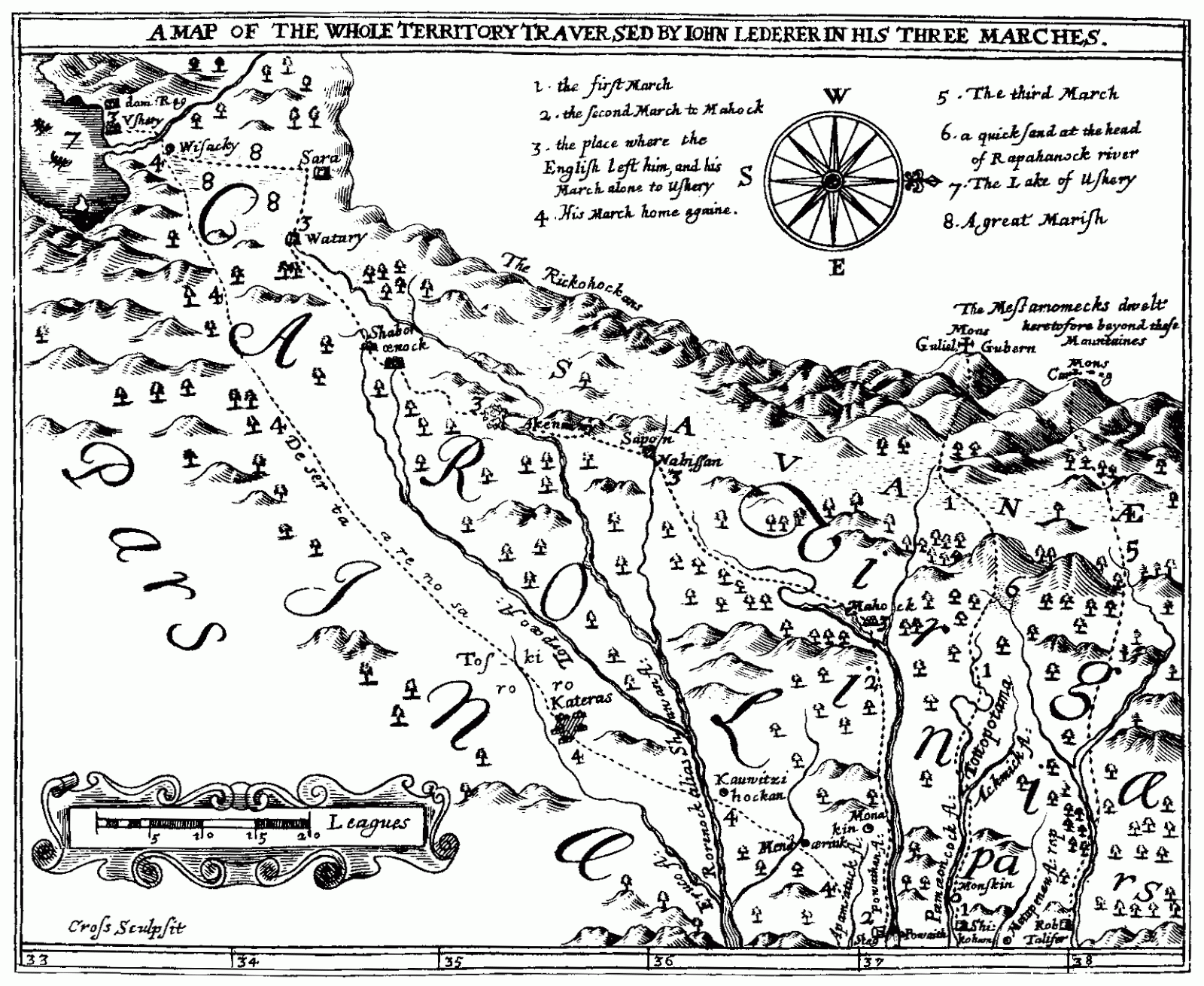
A General MAP of the whole Territory which he traversed. Collected and Translated out of Latin from his Discourse and Writings, By Sir William Talbot Baronet. Sed nos immensum spatiis confecimus aequor, Et iam tempus equum fumantia solvere colla. Virg.Georg. London, Printed by J.C. For Samuel Heyrick, at Grays Innegate in Holborn. 1672. We have –
My LORD,
From
this discourse it is clear that the long looked-for discovery of the
Indian Sea
does nearly approach; and
Carolina,
out of her happy experience of your Lordship's success in great
undertakings, presumes that the accomplishment of this glorious
Designe is reserved for her. In order to which, the Apalataean
Mountains
(though like the prodigious Wall that divides China
and
Tartary,
they deny Virginia
passage
into the West Continent) stoop to your Lordship's Dominions, and lay
open a Prospect into unlimited Empires; Empires that will hereafter
be ambitious of subjection to that noble Government which by your
Lordships deep wisdom and providence first projected, is now
established in Carolina;
for it will appear that she flourishes more by the influence of that,
than the advantages she derives from her Climate and Soyl, which yet
do render her the Beauty and Envy of North-America.
That
all her glories should be seen in this Draught, is not reasonably to
be expected, since she sate to my Author but once, and then too with
a side-face; and therefore I must own it was never by him designed
for the Press, but published by me, out of no other ambition than
that of manifesting to the world, that I am, My
Lord,
Your Lordships most humble and obedient Servant,
William
Talbot.
And
Talbot also wrote –
That
a Stranger should presume (though
with Sir William
Berkeley's
Commission)
to
go into those Parts of the American
Continent
where Englishmen
never
had been,
and
whither some refused to accompany him,
was,
in
Virginia
look's
on as so great an insolence,
that
our Traveler at his Return,
instead
of Welcome and Applause,
met
nothing but Affronts and Reproaches;
for
indeed it was their part,
that
forsook him in the Expedition,
to
procure him discredit that was a witness to theirs:
Therefore
no industry was wanting to prepare Men with a prejudice against him,
and
this their malice improved to
such
a general Animosity,
that
he was not safe in Virginia
from
the outrage of the People,
drawn
into a persuasion,
that
the Publick Levy of that year,
went
all to the expense of his Vagaries. Forced by this storm into
Maryland,
he
became known to me,
though
then ill-affected to the Man,
by
the stories that went about of him:
Nevertheless
finding him,
contrary
to my expectation,
a
modest ingenious person,
&a
pretty Scholar,
I
thought it common Justice to give him an occasion of vindicating
himself from what I had heard of him;
which
truly he did with so convincing Reason and circumstance,
as
quite abolished those former impressions in me,
and
made me desire this Account of his Travels,
which
here you have faithfully rendered out of Latin from his own Writings
and Discourse,
with
an entire Map of the Territory he traversed,
copied
from his own hand. All these I have compared with Indian
Relations
of those parts (though
I never met with any Indian
that
had followed a Southwest-Course so far as this German)
and
finding them agree,
I
thought the Printing of these Papers was no injury to the Author,
and
might prove a Service to the Publick.
William
Talbot.
We know John Lederer was commishoned by Governor William Barkeley “to go into those Parts of the American Continent where Englishmen never had been.” What did ledered find on his three journies?
Lederer's
contact with the Monacan's and Saponi's
The
following is an interesting observation made in Lederer's work. He
states;
“The
Highlands (in Indian, Ahkontshuck)
begin at those falls, and determine at the foot of the great ridge of
Mountains that runs through the midst of this Continent, Northeast
and Southwest, called by the Spaniards Apalataei,from
the Nation Apalakin;and
by the Indians, Paemotinck.
According to the best of my observation and conjecture, they lie
parallel to the Atlantick
Sea-coast,
that bearing from Canada
to
Cape Florida,
Northeast and Southwest, and then falling off due West as the
Mountains do at Sara:
but here they take the name of Suala;
Sara
in
the Warrennuncock
dialect
being Sasa
or
Sualy.”This
of interest for several reasons. Occasonaly you see records of the
various Siouan cities given one name, and at others the same people
are given a different name. He speaks of some mountains called
“Ahkontshuck” in “Indian” but the Spanish call them
“Apalataei”. Then in the next sentence he talks about a place
called “Sara”, then says “but here they take the name “Suala”
or “Sualy”. That duality Xualla and Joara. The Elglish first
sopke of the Saura people, then later we hear them called “Cheraw”.
Maybe this denotes a diffrence in the dialects of the Saponi and
Monacans of the North and the Catawban/Iswa people to the south – I
don't now. But it does show slight variations in pronounciation, as
well as showing that when the should be expected, and the spellng and
pronounciation of varioous locations may vary – learn to look for
and expect that variance.
Quoting from Lederer's account;
“These
parts were formerly possessed by the Tacci,alias
Dogi;
but they are extinct; and the Indians now seated here, are
distinguished into the several Nations of Mahoe,
Nuntaneuck,
alias Nuntaly,
Nahyssan,
Sapon,
Managog,
Mangoack,
Akenatzy,
and Monakin,
et cetera. One Language is common to them all, though they differ in
Dialects. The parts inhabited here are pleasant and fruitful, being
cleared of Wood, and laid open to the Sun. The Valleys feed numerous
herds of Deer and Elks larger than Oxen: these Valleys they call
Savanae,
being Marish grounds at the foot of the Apalataei,
and yearly laid under water in the beginning of Summer by flouds of
melted Snow falling down from the Mountains.”
He talks of tribes that “are now extinct”, the Tacci and the Dogi. We know the Cherokee later called the regions west of the Mountains and to their north “a dark and bloody land”. We know the English found Kentucky virtually uninhabited. We know there were great cities at one time from Illinois to Ohio that were abandoned. We might assume there were terrible Indian wars in the past that depopulated this region. I am afraid that is most of what we can conclude. People can guess all they want, and make wonderful guesses. But we must always remember they are just guessing beyond some basic point, and not forget it.
He mentions all those Eastern Siouan city states – saying they speak the same language, with local differences from town to town, band to band. He then tells of several bands of the Catawba Nation: Mahoe, Nuntaneuck (aka Nuntaly), Nahyssan, Sapon, Managog, Managoack, Akenatzy, Monackin. I suspect what Lederer calls “tribes” are actually “cities” or “villages”. If you remove the “Nah” pefix as well as the last letter “n” from Nahyssan you get “Yssa”, a major city in the Catawba confederation, recorded by the Spaniards. “Akenatzy” is obviously “Occoneechi” from a later date. We also recognize“Monackin” and “Sapon.” “Mahoe”, “Managog” and “Managoack” are obviously the same as “Manahoak” as well. “Nuntaneuck” is the only one I haven't seen before, and can't explain in some manner. The last surviving speaker of the Tutelo language that went to live with the Six Nations said the word for all the people was “Yesah” – and I can't help but recall in the south, the word for all the people was translated in several ways – Esaw, Issa/Iswa, Yssa – it is the same word translated slightly differently by different scribes.
He mentions seasonal lakes being formed from the melt of the mountain snows, but perhaps some of these lakes were due to beaver dams that are now gone. Perhaps the people learned from the beaver and created a few dams themelves. He mentions “elk larger than oxen”. These animals can only be the Eastern Bison now extinct. No other animal was “larger than oxen”. They were said to have been smaller than bison of the western prairie, but very similar. The Mississippi River would have been a major barrier for western and eastern animals to cross back and forth.
About
the People's Customs and Ways
As
Leaderer continues, he breaks for a moment to talk about the people
he meets.
“The Indians now seated in these parts, are none of those which the English removed from Virginia, but a people driven by an Enemy from the Northwest, and invited to sit down here by an Oracle above four hundred years since, as they pretend: for the ancient inhabitants of Virginia were far more rude and barbarous, feeding onely upon raw flesh and fish, until these taught them to plant Corn, and shewed them the use of it.
“But before I treat of their ancient Manners and Customs, it is necessary I should shew by what means the knowledge of them hath been conveyed from former ages to posterity. Three ways they supply their want of Letters: first by Counters, secondly by Emblemes or Hieroglyphicks, thirdly by Tradition delivered in long Tales from father to son, which being children they are made to learn by rote.”
comment: The first paragraph says some newcomers arrived about 400 years earlier.Since this was written about 1670, 400 years earlier makes it the year 1270 since the arrival of the “newcomers”. There are peple who believe the Creek descend from the maya Indians. Many Mayan towns were abandoned at an earlier date. Could this be them? Perhaps they brought “corn” with them and it spread all across North America. This is just conjecture. Also of note is the mention that originally the people ate raw fish and meat. I can't believe they didn't know how to make a fire. How would they have stayed warm in winter? But when they had vegetables like “corn” that can be dried, ground up, or eaten frech, they needed a fire to hydrate the dried corn. And since they already had a fire, they started cooking their meat more often.
As for the second paragraph, it is equally chanlleging. It says they had a form of writing. They had a means of describing numbers. They had some type of hirogriphics. That would be where a symbol represented a word. And they also passeddown stories from farther to son, or from mother to child.Thinking of the Maya again, they DID have a written language. This implies that they did want to pass down their knowledge from generation to generation. They wanted what they know to be passed down to us.
He continues;
For
Counters, they use either Pebbles, or short scantlings of straw or
reeds. Where a Battle has been fought, or a Colony seated, they raise
a small Pyramid of these stones, consisting of the number slain or
transplanted. Their reeds and straws serve them in Religious
Ceremonies: for they lay them orderly in a Circle when they prepare
for Devotion or Sacrifice; and that performed, the Circle remains
still; for it is Sacriledge to disturb or to touch it: the
disposition and sorting of the straws and reeds, shew what kinde of
Rites have there been celebrated, as Invocation, Sacrifice, Burial,
et cetera.
Comment: If there was a battle fought at a location, the dead were honored y placing a pile of rocks at the location. There is mention of a new colony being formed and moved to another location. This makes perfect sense. A parcel of ground can support only so many people. As a town grew, they could sense the number of deer harvested was growing smaller, the numbers of fish cught in the streams dwindled, and the wild fowl became scarcer and scarcer. There'd come a time when they'd have to separate into two bands. They might place the number of the new town in a particular spot, possibly a holy spot, so that a generation later they could determine if they were growing or shrinking in number. In short, the people had ceremonies, and Lederer was trying to speculate as to their meaning, as I have done. No matter how much I “guess” I can never presume to know. That would be very arrogant of me.
He continues –
“The
faculties of the minde and body they commonly express by Emblems. By
the figure of a Stag, they imply swiftness; by that of a Serpent,
wrath; of a Lion, courage; of a Dog, fidelity; by a Swan, they
signifie the English, alluding to their complexion, and flight over
the Sea.
“An account of Time, and other things, they keep on a string or leather thong tied in knots of several colours. I took particular notice of small wheels serving for this purpose among the Oenocks, because I have heard that the Mexicans use the same. Every Nation gives his particular Ensigne or Arms: The Sasquesahanaugh a Tarapine, or small Tortoise; the Akenatzy's a Serpent; the Nahyssanes three Arrows, et cetera. In this they likewise agree with the Mexican Indians. Vid. ]os. à Costa.”
Comment:
I was intrigued by the measurement of the concept of time. What he
calls “Oenocks” are better known as the “Eno”.Lederer says
the Eno had “small wheels”. But the American Indian peoples never
invented the wheel. Each band also had a symbol that represented it.
A symbol of 3 arrows would imediately be understood by other Catawban
bands – but non-Catawban people wouldn't have a clue what it
represented. Leaving marks in the soil, or symbols carved into the
bark of trees would have been a means of communication.
Continuing
the narative;
“They
worship one God, Creater of all things, whom some call Okaeè
others
Mannith:
to him alone the High priest, or Periku
offers
Sacrifice; and yet they believe he has no regard to sublunary
affairs, but commits the Government of Mankinde to lesser Deities, as
Quiacosough
and
Tagkanysough,
that is, good and evil Spirits: to these the inferior Priests pay
their devotion and Sacrifice, at which they make recitals, to a
lamentable Tune, of the great things done by their Ancestors.
“From four women, viz. Pash, Sepoy, Askarin,and Maraskarin,they derive the Race of Mankinde; which they therefore divide into four Tribes, distinguished under several names. They very religiously observe the degrees of Marriage, which they limit not to distance of Kindred, but difference of Tribes, which are continued in the issue of the Females: now for two of the same Tribe to match, is abhorred as Incest, and punished with great severity.”
comment: “Mannith” is smilar to “Manitou.” He seems to imply “Quiacosough” means “good spirits” and “Tagkanysough” means “bad spirits”. He mentions all mankind being brrn from four women. I can see the similarity of “Sepoy” and “Saponi”. I see If you simply add “Mar” to “Askarin” you get the the second and third woman founders.When they say people of the same tribe can not mate, he mans people of the same community. That is, a Saponi could not marry another Saponi, or an Eno couldn't marry another Eno. Citizens of a village must have been very closely related to one another. For thi law to have had to have been enacted.
He continues talking about death rituals and so on. As for intellect of the Indians, he says;
“I have been present at several of their Consultations and Debates, and to my admiration have heard some of their Seniors deliver themselves with as much Judgement and Eloquence as I should have expected from men of Civil education and Literature.”
comment: American Indians have always been brilliant orators.
On the 13th of March, 1669, Lederer purchased a stone from the Indians and gave it to Gov. Brekeley.
In May he starts his second expedition. He says;
“The twentieth of May 1670, one Major Harris and my self, with twenty Christian Horse, and five Indians, marched from the Falls of James-River, in Virginia, towards the Monakins; and on the Two and twentieth were welcomed by them with Volleys of Shot. Near this Village we observed a Pyramid of stones piled up together, which their Priests told us, was the Number of an Indian Colony drawn out by Lot from a Neighbour-Countrey over-peopled, and led hither by one Monack, from whom they take the Name of Monakin. Here enquiring the way to the Mountains, an ancient Man described with a staffe two paths on the ground; one pointing to the Mahocks, and other to the Nahyssans.
Comment: This confirms what we thought earlier. The land could support only so many people. The names of many bands were often derived from their founders or chiefs.
He talks of the flour that Lederer's men took with them, how it turned bad. The Indian corn however remained good to eat.
So we know that in 1670 these northern bands of the Catawban peoples were still strong communities.
Please remember Lederer's account of Northern Catawban band's customs and ways is the only account I have found. Anytime anyone looks at another person's culture, we are viewing it through glasses tinted by our own culture.Europeans considered many American Indian practices as extremely cruel (which was true) while forgetting their own culture was still burning witches alive, as Catholics and Protestant's were doing to one another, as well. But no matter how objective Lederer might have tried to be, there is no way in his short span of time that he could have understood the rituals and customs of the Northern Catawba Bands of Indians. Nor is there any means by which I can understand them, either. I merely make suggestions as to why something might have been done.
John Lawson
About 1701 we have the accounts of
another traveller, John Lawson.
Quoting
Hudson; Our
fullest early description of the Catawba comes to us from from the
hands of John Lawson who visited them in January 1701 while on a
journey from Charleston, South Carolina to the mouth of the Tar River
in North Carolina. Having made contact with the Sewee, Santee,
Congaree, and Wateree Nations while traveling on foot up the eastern
banks of the Santee-Wateree-Catawba River system, he came upon the
Catawba Nation situated a few miles from the present day 'Old
Reservation'. (14)
First, we must make an effort to understand the people he is talking about. Hudson refers to the 'nations' of the Wateree, Congaree, Sewee, Santee, and Catawba. These are all part of ONE nation, one People, and NOT separate nations. It appears that some of the English only had a vague notion of this concept, where the Indians were concerned. What happens to each of these groups only makes sense once we realize they are all part of one greater confederated nation.
Hudson
adds; “The
Waxhaw, Esaw, and Sugaree Nations were situated near the Catawba
Nation, and all four appear to have been closely related.”
Apparently, Lawson tells little about the Catawba proper, but he does give a description of some of these other bands. Of these, Hudson tells us; Upon arriving among the Waxsaws, Lawson was entertained in a cabin that impressed him as being unusually large and well built. The Indians of these four nations lived in villages scattered through an area at about ten miles across. Each of these villages had a 'theatre' or 'stage-house' that was larger in size and different in construction from the bark-covered houses in which they lived. In these public buildings, ambassadors from other nations were received, political affairs were deliberated, and rituals were performed. Each village apparently had a government council of elders with a residing king and war captain, the relationships among these being governed by a personal code of etiquette. At the same time as Lawson's visit, an ambassador came from the Saponi Nation, located 150 miles to the north. (15)
He speaks of dances performed for him, saying at the end of the dance the young men took their “sexual license” with as many as wanted, taking a woman for a “bed-fellow.” When reading these things, please remember Lawson had no prior knowledge of these people, and he did not speak their their language. For all we know, these men's wives might have been there watching their husband's dancing. These warriors and the female “bed fellows” he mentions, might have known one another better than Lawson ralized. American Indian females in such matters might have had more say in their freedoms than did their Eurpoean female counterparts.
Also note when speaking of the Waxsaw, Esaw, Sugaree and Catawba, he speaks “of these four nations” . . . They are clearly part of the same single nation. These are in reality more like four bands, four counties, four city-states, or what-ever designation you think more proper. They are confederated together in sucha way that if one needs help, the others can come to their aid if necessary. It is a mutually benefecial arraingement. Also note he speaks of EACH Waxsaw village as though there were several. Later se simply hear of THE Waxsaw village. The numbers of the people are in decline. Thirty years earlier Lederer spoke of the Saponi amd Monacan as though their numbers were on the rise, now the reverse seems to be the case.
Apparently, Lawson tells little about the Catawba proper, but he does give a description of some of these other bands. Of these, Hudson tells us; Upon arriving among the Waxsaws, Lawson was entertained in a cabin that impressed him as being unusually large and well built. The Indians of these four nations lived in villages scattered through an area at about ten miles across. Each of these villages had a 'theatre' or 'stage-house' that was larger in size and different in construction from the bark-covered houses in which they lived. In these public buildings, ambassadors from other nations were received, political affairs were deliberated, and rituals were performed. Each village apparently had a government council of elders with a residing king and war captain, the relationships among these being governed by a personal code of etiquette. At the same time as Lawson's visit, an ambassador came from the Saponi Nation, located 150 miles to the north. (16)
He speaks of dances performed for him, saying at the end of the dance the young men took their “sexual license” with as many as wanted, taking a woman for a “bed-fellow.” When reading these things, please remember Lawson had no prior knowledge of these people, and he did not speak their their language. For all we know, these men's wives might have been there watching their husband's dancing. These warriors and the female “bed fellows” he mentions, known one another better than Lawson ralized. American Indian females in such matters might have had more say in their freedoms than did their Eurpoean counterparts.
In 1701 John Lawson found the Saponi dwelling on the Yadkin River in North Carolina near the present town of Salusbury, North Carolina. Haithcock next mentions that the Saponi had moved by 1711 to a place called “Sapona Town,” a short distance from the Roanoke River, 15 miles west of Windsor, Bertie County, North Carolina. This was shortly before the Tuscarora War of that same year. This means the Saponi, Eno, and Sisipahaw all three lived near the Tuscarora. Haithcock mentions one Saponi took the name “Johnson”, after a settler named John Johnson, who lived at Sapona Town. In 1713 Virginia's governor, Alexander Spotswood, established some lands for the Eastern Siouans from Virginia. Elements of the following bands were reported to have gone there, to a place called “Fort Christanna”; Saponi, Tutelo, Occoneechi, Meiponstky, Monacan, and the Stegarsky. These all came to be called the Saponi Nation. Tanhee Soka, Saponi, signed his mark at Fort Christanna. (17).
So
the Northern Catawban bands (which included the Saponi and others)
were almost constantly on the move from the 1670s until they arrived
at Christanna in 1713. That's between 40 and 50 years. During this
time their numbers decreased drastically. They were apparently
enslaved, died of disease, and in the slave wars, often instigated by
South Carolina traders.
John Lawson visited the Saponi town when it was located on the Yadkin River in 1701., near the present town of Salisbury. Per Haithcock, they then moved to Bertie County, North Carolina with the Tutelo. He states that the Saponi, Tutelo, and Occoneechi, had moved to a 'new town', called Sapona Town, just before the Tuscarora War. He states their town was east of the Roanoke River, about 15 miles west of the present day town of Windsor, Bertie County, North Carolina. He mentions an 'Indian surnamed Johnson, and there was a Caucasian named 'John Johnson' living at the town of Sapona.
James Mooney was first to refer to the Catawba as “Eastern Siouan”. Hudson disagrees with some of Mooney's conclusions. In making his case, he makes a very important observation. While quoting Sapir, he says, “ . . . as Sapir was careful to point out, inferential evidence must be subjected to vigorous scrutiny and methodological rigor, otherwise it can lead to a to a badly distorted reconstruction, particularly in the hands of someone with a “theory”.(Sapir 1951:394).
Mooney was
ahead of his time on this topic, especially with regards to the
Melungeons – people should heed his warning. We have all of these
ridiculous ideas as to theorigin of the Melungeons while reality is
staring them in the face.
This is so very important as we shall see before the end of this book. One of the main reasons I am writing this is to explain why so many ideas about the Melungeons are in error. It is my hope that seeing the true origins of the Melungeons will will help develop some pride in their American Indian heritage, and that they shall learn to reject the many theories about their origins that are pure and utter nonsense.
Unknown Explorers
In 1670, when John Lederer pased through a Monacan village, they were greeted by a volley of muskets, it was described as a sign of greeting. In 1671 Batts and Fallam mentioned fire arms were discovered in the Saponi village on the Staunton River. The same expedition mentions the Tutelo village near present day Salem, Virginia, gave a few shots of powder to a Mohetan Indian, stating his people were then living on the Kanawha River. Since both the colonies of South Carolina and Virginia forbade the sale of firearms to the Indians at this time, the presence of all these weapons is a puzzle. Indians at the coast had much easier access to muskets, thus making Indians in the interior easier victims in the slave trade.
No one has successfully explained the origin of these firearms. One comment made by Abraham Wood. however, might explain their origin. Woods mentions the Tomahittan Indians of the southern Appalachians had visited him. And stated that they had about 60 guns “which were not of English manufacture.” I suspect these Tomahittans were actually Indians from Florida, although many acquaint them with the Cherokee, and they might be right. I just want to dot all my eyes, and cross all my t's. Wood sent Gabriel Arthur to live with them as a preliminary to trade. Apparently they forced Arthur to travel with them on raids, and he reported them on a raid to a Spanish town. They spotted a Spaniard and killed him, taking his weapons. This might account for some of the weapons the Indians of the interior possessed, but I suspect some South Carolina and perhaps Virginia traders also traded illegally in weapons (18), however evidence is wanting. Hudson gives a possible explanation for the Virginia Traders not writing about their exploits. He says, “. . . the Virginia traders left little or no account of their dealings with the Indians. Their failure in this was intentional . . . they wanted to to conceal their illegal dealings in arms and ammunition.”
There are many possibilities here. Maybe Virginia traders were selling muskets to the Indians. Traders were always selling things that were declared illegal to the Indians from the days of the founding of Jamestown in 1607 until the end of the Indian Wars near the end of the 19th century. But we also have these Tomahittan Indians who had purchased weaponry that “were not of English manufacture. Many equate the Tomahittan Indians with the Cherokee. Others say they were the Nottaway. They could have purchased weapons from the Spanish in Florida or from the French somewhere along the Mississippi River. I suspect there is no way they'd sell their weapons to neighboring tribes. Tribes were always fighting one another. Why provide them with weapons? That makes no sense.
References
(1) The Catawba Nation, by Charles M. Hudson, p 16-20
(2) [Euchee story] -- find reference
(3) The Southeastern Indians, by Charles Hudson, p 107-115
(4) Ibid. p. 110
(5) Catawba Nation, Treasures in History, Thomas Blumer, p. 20-22.
(6) Quoted by Charles Hudson in "The Joan Pardo Expeditions; from Frances Lopez de Gomara, Historia general de los Indias, Madrid, 1932, vol. 1, pp. 89-90, translated in New American World: A Documentary History of North America to 1612, ed. David B. Quinn, New York, : Arno Press, 1979, vol. 1, p. 248.). (Peter Martyr, De Orbe Novo, ed. And trans. F. A. MacNutt (New York, 1912, vol. 2, pp. 254-271.).
(7) The Catawba Nation: Treasures in History, Thomas Blumer, p 23-24
(8) The Juan Pardo Expedition, by Charles Hudson, p. 25
(9)
The Juan Pardo Expedition, by Charles Hudson p. 26-27
(10)
Https://www.warhistoryonline.com/instant-articles/lost-spanish-fort-found-great-smoky
mountains.html
(11) https://archive.org/stream/firstexploratio02bidggoog/firstexploratio02bidggoog_djvu.txt. Harvard University Library of the Peabody Museum of American Archaeology and Ethnology GIFT of Lombard C. Jones; Falmouth, Massachusetts ; The First Explorations of the Trans- Allegheny Region by the Virginians 1650-1674; By Clarence Walworth Alvord and Lee Bidgood; The Arthur H. Clark Company; (c) 1912
(11) https://archive.org/stream/firstexploratio02bidggoog/firstexploratio02bidggoog_djvu.txt. Harvard University Library of the Peabody Museum of American Archaeology and Ethnology GIFT of Lombard C. Jones; Falmouth, Massachusetts ; The First Explorations of the Trans- Allegheny Region by the Virginians 1650-1674; By Clarence Walworth Alvord and Lee Bidgood; The Arthur H. Clark Company; (c) 1912
(12)
“The Catawba Nation,” by Charles M. Hudson, p. 35-36
(13) The Discoveries of John Lederer, by John Lederer, 1672
(13) The Discoveries of John Lederer, by John Lederer, 1672
(14)
The Catawba Nation,” by Charles M. Hudson, p. 1
(15)
The Catawba Nation,” by Charles M. Hudson, p. 2
(16) ditto
(17)
“The Catawba Nation,” by Charles M. Hudson, p. 32-33
(18) http://www.ibtimes.com/long-lost-fort-san-juan-discovered-appalachian-mountains-oldest-inland-european-fort-built-40-years -- warning -- this website has changed. There are at present several pop-ups that are hard to get rid of. makes the website very frustrating. Might be better offto do a google search for -- "Fort San Juan" pardo -- there are several such links.
(18) http://www.ibtimes.com/long-lost-fort-san-juan-discovered-appalachian-mountains-oldest-inland-european-fort-built-40-years -- warning -- this website has changed. There are at present several pop-ups that are hard to get rid of. makes the website very frustrating. Might be better offto do a google search for -- "Fort San Juan" pardo -- there are several such links.
Maps
(1) Taken from "Juan Pardo Expeditions", p. 7, Early European Exploration of North America, (c) 1990, Charles Hudson, University of Alabama Press, originally published by the Smithsonian Institution
(2) Ibid., p 9, Swanson proposed a different route for De Soto's expedition. However with Hudson's route, the terrain and peoples and known town's agrees more with Hudson's route as shown on this map.
(3) Ibid. p. 24. Juan Pardo's first expedition showing Moyano's foray into what was probably Cherokee Territory that were given Muscogeean names because the Spanish used Muscogeean guides.
(4) Ibid. p. 33. Towns and locations mentioned in Pardo's second expedition. Notice the town of "Otaro". Thornton mentions "Otero" as being the capital city of the Westo. I asked him online to cite the source of this information and he said for that information I needed to buy his books. But he never told me where I could purchase one. He says it is west of the Appalachians but on this map it is not.
(5) Map showing the Territory over which Lederer ranged in his travels, translated from the original Latin by Sir William Talbot Baronet
Photos
(1) Fort San Juan is the earliest known European fort in the interior of the U.S. It is one of several that were built along the trail they forged from the Carolina's to eastern Tennessee, over the Smokey Mountains.
No comments:
Post a Comment