CHAPTER III, WAR
As with the last chapter, the maps are off and the citations are, too -- will have to finish both later.
Per
Blumer, the Tuscarora Wars has several causes. He says I.] The
Indians objected to the settlement of New Bern, North Carolina in
1710. ii.] The Indian traders also cheated the Tuscarora Indians
regularly. The last straw was iii.] The ill treatment of intoxicated
Tuscarora by a settler. This caused a major confrontation with North
Carolina. Also Seneca agitation pushed the Tuscarora towards a major
confrontation with North Carolina. Remember many of these Indian
Traders were the scum of the earth. They would make it mpossible for
the Indians to pay them back, then at the last minute tell them if
they capture enemy Indians for use in the lsave trade, their debt
would be forgiven. This happened once too many times to the
tuscarora, an they got to the point where they couldn't take it
anymore, and they picked up the hatchet against the English.
The
Tuscarora attack was carefully planned. At dawn, September 22nd,
1711, over 130 settlers were killed by noon. Survivors fled to Bath
and New Bern. For the next four months, the Tuscarora pillaged at
will. Captives were regularly tortured, and eventually executed.
North
Carolina was a small, weak colony at the time. South Carolina finally
had the excuse they'd waited for a long time, and siezed the moment
to attack the Tuscarora. They hoped to become rich selling off the
Tuscarora into slavery. South Carolinian Captain John Barnwell left
Charles Town with only 30 men, but travelled inland to recruit
Piedmont Indians and then pounce on the Tuscarora from the west.
Blumer says that it is thought the Tuscarora had only recently moved
south into North Carolina, onto Catawban lands. I do not know the
evidence for this. But we do know the Tuscarora and the Catawba were
traditional enemies, and this had been the case for some time. They
needed no convincing to go to war with the Tuscarora. The Yamassee
were also recruited. The Tuscarora were no match for their combined
forces. Blumer says Barnwell recruited 500 Indians, 350 of which were
Catawba and their allies. Blumer mentioned Congaree, Waxhaw, Wateree,
Cheraw and others allied to these Catawban peoples. The rest were
Yamasee. Thornton believes the Yamasee were of Muscogeean origin,
saying the term “yama” implied they had been traders themselves.
Blumer
gives an impressive view of what a Catawba warrior looked like in the
old days. I feel I need to report what he says of their appearance.
He says:
He says:
“The
Catawba and their allies went to war in the traditional way. The
women combed their men's hair with bear grease and red root. The
men's ears were decked out with feathers, copper, wampum, and even
entire birds wings. The men painted their faces with vermillion.
Often one eye was circled in black paint, and the other in white.”
War
dances were performed, and the men set out looking as fierce as
possible.
Blucher
goes on to say some had guns and others had bows and arrows. He says;
“In
full traditional battle attire, the Catawba must have been an
impressive site. The name of the Catawba War Captain who led the
nation on this expedition has been lost to history. None of the
Indians would enter a war party without the urging of a powerful war
captain who had won the right to carry snake images on his person in
paint or tattoo.”
Earlier
we saw that the snake image was associated with the Occoneechi.
However there is no mention of the Occoneechi as being a part of this
war party, so maybe something else is in play. Now Indian warfare was
not as Barnwell had expected. The first battle was at the Tuscarora
village of Narhantes. The Catawba took as many captives as they could
get their hands on, and headed for the slave markets of Charleston to
sell them. The Catawban peoples seem to have expected this as just
another slave raid. It makes me wonder if they'd been on other slave
raids. They seemed to know exactly where the slave markets were. By
the end of February 1712, Barnwell's army consisted of about 90
Whites, and 148 Indians, mostly Yamassees. On March 1st,
Barnwell's army entered Tuscarora King Hancock's town, which was
deserted. On March 5th,
King Hancock's fort was surrounded. He threatened to torture his
captives in frout of Barnwell's men. Both sides agreed to hold a
conference on March 19th
at
Bachelor's Creek. The Tuscarora did not show up.
Barnwell's
reputation began to slide. He was forced to return to the Catawba
towns, and get them to return to the battle. On April 7th,
Barnwell's reinforced army returned to Hancock's Fort. These attacks
lasted 10 days. Again, his Catawba allies gathered as many captives
as possible, and headed to the slave markets of Charleston.
Blumer
adds;
“Disappointed
but determined to turn a profit, Barnwell on the pretext of a
meeting, met with the Indians Near Bern. Once inside the fort, these
unfortunate souls were held captive and shipped off to Charleston.
Barnwell would have his profit in Indian flesh.”
As
a result of Barnwell's short but bloody Tuscarora incursions, all the
Indians lost their confidence in the Christian Whites. The Tuscarora
began their exodus to Canada, to be with their Iroquoian relatives.
The Five Nations were destined to become Six, with the addition of
the Tuscarora. They ever afterwards held a grudge against the Catawba
and their allies. Because of Barnswell's actions in obtaining his
own slaves, the Catawba quit trusting the Whites. These events would
lead us to the next war with the Tuscarora.
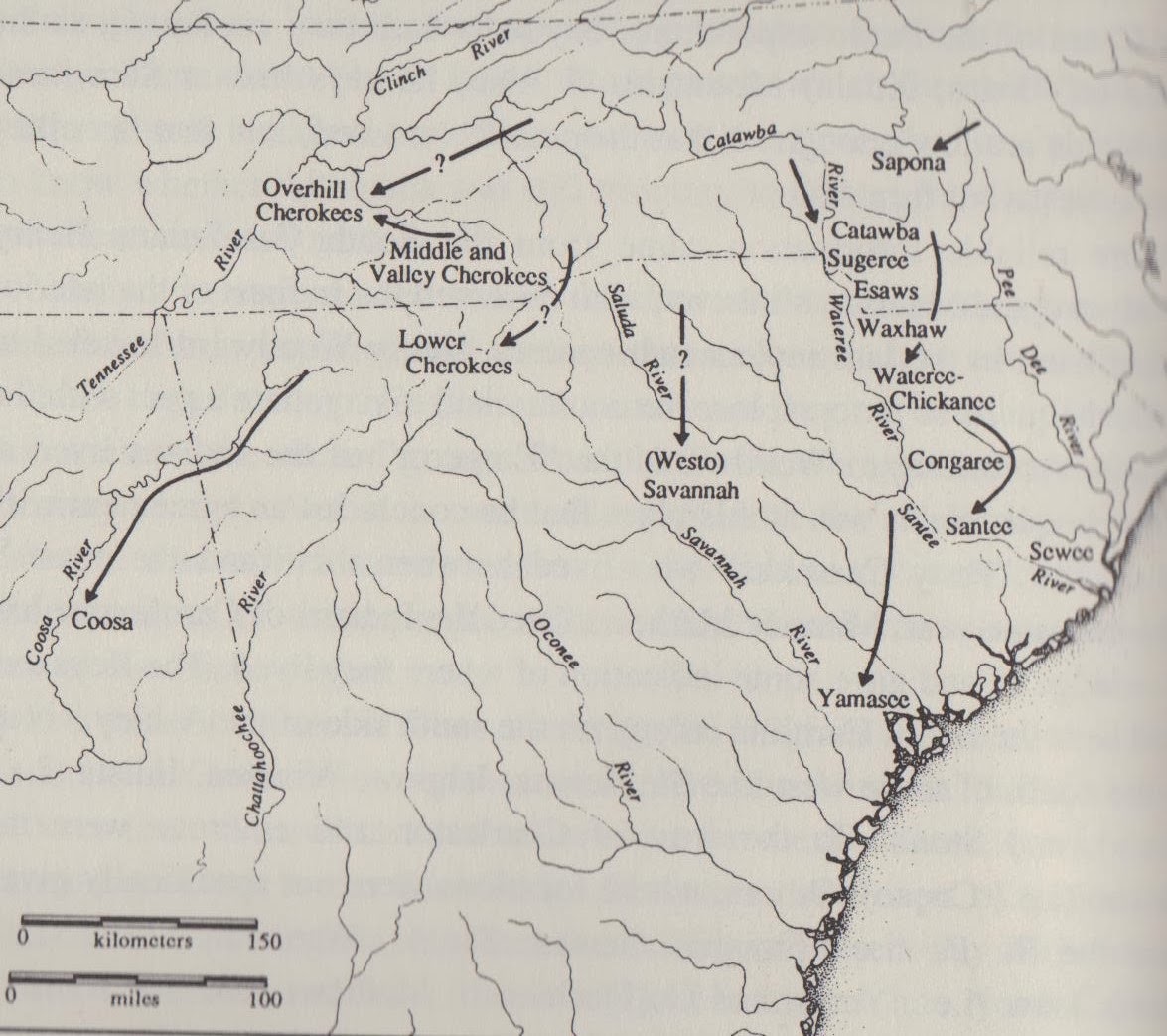
On
the next page
is a map of the route the John Barnwell's troops took on their was to
attack the Tuscarora. The map was from page 36 of Catawba Nation,
Treasures in History, by Thomas J. Blumer. The Tuscarora War lasted
from 1711-1713 and ended in the utter destruction of the Tuscarora
and Coree Indians.
Map 9. The First Tuscarora War

There
is another important Band of the Yesah Nation – the Saura. The
Spaniards found them living in Western North Carolina, and called
them the Xualla (De Soto), or Joara (Pardo). Map 7 has the Saura on
the upper Dan River by 1700. They were said to have left the Upper
Dan in 1703. By the time of the Tuscarora Wars of 1711-1713, they are
on the Pee Dee River (map 8) South and East of the main Catawba
towns, and they took part in the first, but not the second Tuscarora
War (map 9). Map 12 still has the Cheraw on the Pee Dee River in
1720. Many researchers say that the modern Lumbee Indians are
remnants of the Old Cheraw. Map 14 shows the actual locations of
Upper and Lower Saura Towns on the Dan River before they were
abandoned about 1703. About this time frame many Eastern Siouan
cities in the western parts of Carolina and northern Virginia were
abandoned as they removed themselves eastwards and southwards.
On
the deer skin map (map 15) dated 1725 the Charra are one the bands
living near the Catawba. On the 1756 map (map 17) there it is,
Charrow Town next to the Catawba. There is no Charrow Town on map 16,
dated about 1750. They seem to have maintained an existence longer
than many other bands. As I said, many speculate that the modern
Lumbee Indians of Robison County, North Carolina are some of their
descendants.
The
Second Tuscarora War
As
Blumer states, The Tuscarora continued to ravage the countryside,
just before their exodus to the north, in the same way the Israelites
spoiled the Egyptians before fleeing Egypt. Settlers remained behind
palisades and fortresses, afraid to venture out, but doing little to
help themselves, depending mostly of South Carolinians. Some fled the
colony. In June 1712, a delegation of North Carolinians again asked
South Carolina to come to their rescue.
Colonel
James Moore set off from Charleston in October, 1712, to gather an
Indian army. Per Gallay, Moore had led many expeditions to gather
Indian slaves. He led the 1704 raid into Florida to enslave most of
the Apalache Indians. Gallay records that Moore's Indian allies were
Creek. They attacked and wiped out several Appalache towns, taking
hundreds of slaves. He says four Appalache towns moved to South
Carolina which promised to protect them. (x)
Blumer
then says something of note. He says; After
Barnwell's deception, Moore's recruiting was rather slow. Rather than
halt at Waxhaw Town
(as
did Barnwell), he
marched further to the Catawba towns, presumably to coax the Catawba
directly. His first task was to convince the Catawba War captians
that a war against the Tuscarora was to their advantage . . .once the
war captains agreed, they began the war ritual. He took up a pot drum
and danced counterclockwise around his house, performing a call to
war song. When a crowd of men gathered, the war captian recited the
crimes of the Tuscarora against the Catawba. Then the war captain and
their men fasted for three days. They purged their bodies of
impurities with the powerful emetic button snakeroot.
Colonel
Moore crossed the Cape Fear River with 500 Catawba and their Catawban
allies, 300 Cherokee and 50 Yamassee; 33 Whites led the force. They
joined 140 members of the North Carolina militia. [32.]
Meanwhile,
not all the Tuscarora were part of the rebellion. King Blount
delivered King Hancock, leader of the rebellion, to the North
Carolinians, who was then executed. Moore, rather than attack the
Tuscarora, stayed in the North Carolina communities of New Bern, and
Bath, and Albemerle. Without provisions, the Indian army gathered
provisions amongst the settlers, eating their cattle and other
rations. While Moore waited, the Tuscarora strengthened their
fortress at Neoheroka. Their fortress consisted of 1.5 acres of man
made caves, palisaded walls, and strong buildings with a source of
water inside. After a bloody battle, Fort Neoheroka fell on March
20th,
1713. 475 Tuscarora were killed and another 415 were sold into
slavery. This was the end of the Tuscarora resistance. A band of the
Tuscarora remained in North Carolina with King Blount, and others not
sold into slavery. Most however fled north to join their Tuscaroran
relatives who had already fled to live with the Six Nations. [33.]
Blount's band of Tuscarora fled to Virginia at the invitation of
Governor Spotswood where they became close neighbours with the Saponi
who were living next door to them at Fort Christanna.
From
this time forth the Six Nations and the Catawba would be at war until
the power of the Catawba and their allies were completely and utterly
shattered.
Also
notice the mention of how Moore went beyond the Waxhaw. Later a claim
is made that the Catawba destroyed the Waxhaw, but that claim was
made by the South Carolinians. We know it was said there were only 50
Yamassee with Moore, whereas there were hundreds earlier. We also
know Barnwell took friendly Indians as slaves to the slave market in
Charleston. It might be argued that the Waxhaw village and some of
the Yamassee were those so enslaved.
We
shall also see the small pox killed off many of the Indians,
including the Catawba. The Catawban Indians and their confederated
bands proved unable to battle all these foes at one time. Eventually
their numbers were to dwindle to a pitiful few that would forgot much
of their heritage. I hope to write these things to re-asemble a coal
of a fire, to share a lamp of light in the darkness of the history of
the people. There was still one more great war for the Catawba to
fight on their own behalf. At the end of the Yamassee War, the way of
the Carolinas would change forever.
Map 10. The Second Tuscarora War

The
map above shows the routes taken by the warriors and soldiers during
the destruction of the Tuscarora in the second Tuscarora War.
Map
11. The Movements of Some Catawban Bands About 1715
The map below shows the locations of the Southern Bands of the Carolina
Siouans about the year 1715. This would be just after the massacre of
the Tuscarora and Coree Indians, yet just before the Yamassee War, a
war during which many Siouan bands would disappear, or or be so
reduced in number they would be soon forgotten. It is taken from page
186 of 'The Juan Pardo Expedition', Charles Hudson.
The
Northern Bands all were under the banner of the Saponi and near Fort
Christanna. The Central Bands were all East of the Catawba and the
bands associated with them, very close to where the Catawba are today
Those East of the Catawba were mostly in central North Carolina.
There were also the Settlement Indians who lived in and around
Charles Town. Some of these were Creek, some former Spanish allies
from tribes wiped out in the slave raids of Moore and others, and
some most certainly would have been Catawban. Some might have been
freed or runaway Indian slaves whose tribes or bands no longer
existed. Tribal identies were getting blurred as remnants of the
Yamassee, Notchie (found all over the Southeast after their Nation
was destroyed by the French along the Mississippi River), Appalache,
Westo, Chowan (Shawnee), and other wasted tribes would form new
communities huddled together for protection.
Map 12. The Distribution of Indian Tribes about
1715

The
map above is also about the same timeframe, about 1715. Notice the
Cherokees are near where the Coosa Indians (Creek) had been 100 years
earlier, according to Spanish records. The Cherokees are pushing the
Creeks further to the South. The lands of the Siouans are also
shrinking and they aren't realizing it, it seems. They have lost most
of their lands in Virginia and South Carolina as well, to the White
settlers. It was taken from 'The Catawba Indians, The People of the
River', by Douglas Summers Brown, between pages 32 and 33.
The Yamassee War 1715-1717
Although
the next conflict of the era is called “The Yamassee War” of
1715-1716, the Catawba were the largest Indian component with 570
warriors – Blumer tells us that King
Whitmannetaugehehee was king during the time of the Yamassee War. So he must have been the war leader who led his people during those hard times.
I
have found nothing telling which Indians that Moore and Barnwell took
as slaves, other than some of them were the Tuscarora and their
allies, the Core, but they may have taken some of the Piedmont
Indians. It is interesting to note that at one time the Eno were
called allies of the Tuscarora as were the Saxipahaw. Perhaps Barnell
or Moore rounded them up as slaves, and used the excuse that they
were allied to the Tuscarora. That would explain the alliance between
the Yamasee and the Catawban peoples in the next war. They just got
tired of the English betraying them.
The
Yamassee by comparrison, supplied only 400 warriors. According to
Blumer, “All
the Catawban speaking groups in both of the Carolinas joined this
effort to expel the Europeans from the Southeast.”
Per
Blumer; The
Indians had many grievances against the settlers. They included
abuses of a cruel and obscene nature committed by the white traders
who worked among the Indians. i.] Abuses such as murder and rape were
common. ii.] If needed, they would help themselves to the Indians
crops and not pay for the food.. iii.] In addition, the traders
fomented Indian wars to foster the Indian slave trade. iv.] Other
grievances included white settlements that encroached on Indian
lands.
Blumer
says the war was instigated by the Creek Indians, but the settlers
thought it must have been instigated by the French at Mobile Bay, or
the Spaniards at Saint Augustine. Blumer also speaks of the sale of
free Indians into slavery by unscrupulous traders in the Indian
towns. These are many of the causes and sentiments for the origins of
the Yamassee War
of 1715-1716. Virtually every Indian community took part in this
rebellion.
On
April 15th,
1715, ninety percent of the traders working in the Indian towns were
killed. In the process, 40 colonists were killed. South Carolina
mustered an army under General George Chicken. Per Blumer, The
Indians suffered a defeat at Goose Creek, and the Catawba and their
allies had second thoughts about the war. On July 19th
,
1715, the Catawba sued for peace. . . on October 18th,
1715, a delegation [of
Catawba] went
to Williamsburg, Virginia. A
second conference was called on Feburary 4th,
1716. Virginia Governor Spotswood wanted the Catawba headmen to
deliver their sons of their headmen to Fort Christanna. This exchange
occurred by April of 1717. The end of the war occurred when the last
of the Yamassee fled to Fort Augustine, Florida. Those not lucky
enough to flee were sold into slavery. It is thought some of the
Yamassee took shelter with the Catawba, and some with the Creek. But
their tribe is now considered extinct as a nation. An English record
states “Yamassee
speak the same language as the Lower Cherokee . . .”
(1AL1). This record is dated January 24-25,1726. So it is possible
that some Yamassee took refuge with the Lower Cherokee as well. At least
two Yamassee towns, Tomatley and Tuskegee, vanish and are later found
in the Cherokee Nation, and are considered Cherokee towns.
The
Yamasee War
http://scholarcommons.sc.edu/cgi/viewcontent.cgiarticle=1023&context=archmonth_post
Here
is a second account of the war. Chester B. DePratter Ph.D.; South
Carolina Institute of Archaeology and Anthropology University of
South Carolina The Yamasee War Jon Bernard Marcoux Noreen Stonor
Drexel Cultural and Historic Preservation Program Salve Regina
University
On
Good Friday, April 15, 1715, the chaos of war invaded the lives of
the European colonists, enslaved Africans, and Native Americans
living in South Carolina. The Yamasee War began that day when a
number of trade officials were murdered in the Yamasee town of
Pocotaligo. The murders took South Carolinians completely by
surprise, as the Yamasee were thought to be one of the colony's
closest Indian allies. Indeed, the murdered Englishmen had only been
sent to Pocotaligo in order to arrange talks with another Indian
group, the Ochese Muskogeans (later Creeks), who were rumored to be
planning attacks against South Carolina traders and settlers. These
initial murders were quickly followed by major Yamasee attacks on
plantations around Port Royal, near modern day Beaufort, SC. In these
attacks, the Yamasee managed to kill over 100 colonists and set the
rest of the settlement's population to flight. In the following
weeks, news began to filter into Charleston that the English traders
in virtually every southeastern Indian village had either been killed
or chased off. Adding to the fears of a pan-Indian assault, news
emerged that the Catawba and a small group of Cherokee had made raids
on plantations north of Charleston and even managed to capture a
South Carolina militia garrison. Facing this apparent “invasion,”
colonists across South Carolina fled to Charleston, where the effects
of overcrowding, fear, and tension, exacerbated by the summer heat,
took its toll on the physical and mental health of many residents
(Crane 2004; Oatis 2004)
Historians
and archaeologists have been studying this conflict for over two
centuries, yet most of the public is only vaguely aware of the
Yamasee War or its significance outside of South Carolina. Indeed,
historian William Ramsey (2008) states that the Yamasee War
(1715-1717) “easily ranks with King Philip’s War and Pontiac’s
Rebellion” as a key colonial conflict; however, compared to these
other wars, it remains woefully understudied. As we recognize the
300-year anniversary of the conflict, there has been an upsurge in
scholarly interest in the Yamasee War. The results of these new
projects will doubtless provide new insights for understanding this
pivotal moment of the colonial period.
The
Yamassee War included a small number of what might be called major
military engagements, and these were confined to the first three
months of the war. Afterward, hostilities were limited to Yamasee and
Muskogean raids on trading caravans and frontier skirmishes with
South Carolina militia that continued sporadically for the next two
years. Peace with the last of the hostile groups, the Lower Creeks,
officially ended the war in 1717. While rare, the major battles
described below were nevertheless significant, for they included
hundreds of combatants on each side and were fought on two separate
fronts (north and south of Charleston). Furthermore, these battles
were like microcosms of the colonial landscape, defining
relationships among the period’s three major cultural groups –
Europeans, Native Americans, and enslaved Africans. Indeed,
historical accounts of these battles are clear that almost half of
Carolina militia forces was comprised of enslaved Africans.
Pocotaligo and Yamasee Raids on Port Royal: April 15, 1715 At
daybreak on this day, a colonial delegation from Charleston was
brutally tortured and murdered by Yamasees at the town of Pocotaligo
near modern-day Beaufort, SC. The scene is described in chilling
detail by Charles Rodd, a Charleston merchant. In a 1715 letter to
his employers in London (Rodd 1928). Describing the attack and
torture of Indian agent Thomas Nairne writes, “But next morning at
dawn their terrible war-whoop was heard and a great multitude was
seen whose faces and several other parts of their bodies were painted
with red and black streaks, resembling devils come out of Hell…
They threw themselves first upon the Agents and on Mr. Wright, seized
their houses and effects, fired on everybody without distinction, and
put to death, with torture, in the most cruel manner in the world,
those who escaped the fire of their weapons… I do not know if Mr.
Wright was burnt piece-meal, or not: but it is said that the
criminals loaded Mr. Nairne with a great number of pieces of wood, to
which they set fire, and burnt him in this manner so that he suffered
horrible torture, during several days, before he was allowed to die.”
Rodd goes on to describe the harrowing escape of families from their
plantations around nearby Port Royal as the Yamasees began their war.
You
might wonder about poor Mr. Nairne. He seems to have been
deliberately chosen to be tortured. Perhaps he was. He was one of the
biggest dealers in Indian slaves around. Such
slave raiding took place on a great scale. In 1715 trader Thomas
Nairne boasted that the Yamassee Indians had raided the Florida Keys
for slaves as Indians further north in Florida had for all intents
and purposes, vanished, due to all the slave raids. The Indians
finally grew tired of the South Carolina traders, and this resulted
in the Yamassee War of 1715-1717. Hudson says this war was an end to
the Santee, Sewee, Pedee, Congaree, Cusabo and Waxhaw Bands. We hear of the Pedee later, but of the others, we hear very little after this time.
The
“Sadkeche Fight” and Carolina Counter Offensive against Yamasee
Towns: late April, 1715
South
Carolina's military response to the Yamasee raids was swift. Only a
week after the murders
at Pocotaligo, Governor Craven of South Carolina personally led
militia forces against the Yamasees in their own towns. He sent some
of his forces to attack Pocotaligo by water, while he mustered some
250 men to attack overland. Part of this offensive is a battle now
called “The Sadkeche Fight.” In this engagement, Craven was
ambushed in camp while on his march to Pocotaligo somewhere on the
Combahee River near Salkehatchie, SC. A weekly broadside called The
Boston Newsletter, reported on the battle stating, “The Governor
marched within Sixteen miles of [Pocotaligo], and encamped at night
in a large Savanna or Plain, by a Wood-side, and was early next
morning by break of day saluted with a volley of shot from about Five
hundred of the enemy; that lay ambuscaded in the Woods, who
notwithstanding of the surprise, soon put his men in order, and
engaged them so gallantly three quarters of an hour, that he soon
routed the enemy; killed and wounded several of them; among whom some
of their chief Commanders fell” (June 6, 1715). Meanwhile, the
Carolina militia forces sent by water scored decisive victories
against the Yamasee towns near Beaufort, forcing those groups to
retreat southward across the Altamaha River in present-day Georgia.
Santee Raids and Captain Chicken’s Charge: mid May-early June 1715
to Carolina settlers, the scale and violence of the Yamasee attacks
on Port Royal must have been frightening. These fears, however, must
have quickly multiplied when news emerged that a second group of
raids was taking place at plantations along the Santee River north of
Charleston. The fact that these raids were conducted by the Catawba
and Cherokee stoked rumors that these violent assaults were part of a
pan-Indian revolt aimed at driving Europeans from the region. The
first attack occurred at the plantation of John Herne (Hyrne), near
present day Vance, SC. In his 1715 journal, Goose Creek missionary
Francis LeJau says the Indians “killed poor Herne treacherously,
after he had given them some Victuals [food], according to our usual
friendly manner.” Following this attack, the Indians ambushed a
group of Carolina militia sent to the area to investigate.
Twenty-seven of the militia were killed in this engagement. The
invading force then moved on to a fortified plantation known as
Schenkingh’s Cowpen – a site now submerged under Lake Marion near
Eadytown, SC. Here the group was able to trick the commanding militia
officer to let them inside the palisade under the pretense of
surrender. Once inside the defenses, the group pulled out their
weapons, slayed 22 militiamen, and burnt the garrison. It appears
that the raiding Indian force then began to move toward Goose Creek,
which had largely been deserted. The culmination of engagements on
the northern front happened on June 13, when militia captain George
Chicken led a force out to meet the advancing Indian group. A letter
from Charleston merchant Samuel Eveleigh (1715) gives great detail of
the battle stating, “Capt. Chicken march'd from the Ponds [near
Summerville, SC] with 120 men and understanding that they were got to
a Plantation about 4 miles distant marched thither, divided his men
into three parties, two of which he ordered to march in part to
surround them, and in part to prevent their flight into an adjacent
swamp but before the said party could arrive to the post designed
them, two Indians belonging to the enemy scouting down to the place
where Captain Chicken lay in ambascade [sic] he was obliged for fear
of discovery to shoot them down, and immediately fell upon the body,
routed them and as is supposed killed about 40 besides their wounded
they carried away.” This significant engagement, sometimes known as
“The Battle of the Ponds,” halted the advance of the Piedmont
Indians and marked their withdrawal from the war (they sent a peace
delegation to Virginia about a month later). This battle thus
effectively ended the war on the Northern front.
Apalachee
Raid on New London (Willtown) and the Burning of St. Paul’s Parish:
mid July 1715
A
few weeks after Captain Chicken’s victory, Governor Craven marched
with a militia force of about 200 settlers, enslaved Africans, and
allied Indians in order to launch an offensive against the Piedmont
Indians who attacked the northern plantations. Shortly after crossing
the Santee River, Craven received word that a large force of 500-700
Apalachee and allied groups had crossed over the Edisto River and
attacked the colonial settlement called New London, located on
present-day Willtown Bluff, SC. The garrison at New London prevented
the force from entering the town, so the raiding force set about
attacking plantations across St. Paul’s Parish all the way to the
Stono River. The Indians managed to retreat across the Edisto River
and destroy the bridge before Craven’s militia forces arrived. Once
again, Samuel Eveleigh (1715) describes the action, “…the
Apalatchee and other Southern Indians came down on New London, and
destroy'd all the Plantations on the way, besides my Lady Blakes,
Falls, Col. Evans and several others, have also burnt Mr. Boon's
plantations and the ship he was building. The crops thank God are
still pretty good; the Govr. At that instant had
marched the Army to Zantee [sic], however he returned back on the
first notice upon his approach the Indians fled over Ponpon Bridge
and burnt it having killed 4 or 5 white men. We have not since heard
from them.” This incursion marked the last major engagement of the
Yamassee War. In August, much needed military supplies arrived in
Charleston from Virginia and New England. Also, the colonial assembly
passed an act that funded a 1200 man militia and the construction of
ten substantial forts across the frontier. By August, the Yamassee had
also began their withdrawal south to Spanish territory around the St.
Augustine.
There
seem to have been two forces working together that caused this war.
The first being that the Indians saw, day after day and year after
year, settlers encroaching on their land, eating their deer and wild turkey, leaving little food for themselves. A second reason for the
war was the evil of slavery. Traders demanded the people to gather
slaves of their neighbors, to pay their bills. They simply got tired
of doing this.
The
Aftermath of the War
As
for the instigators of the war, only weeks after their first
successful raids, the Yamasee had lost a quarter of their number to
death or slavery, and they were forced to move their towns south to
seek protection from the Spanish. While not creating as perilous a
situation as that experienced by the Yamasee, the chaos of war caused
a temporary but crucial breach in the fundamental diplomatic and
trading relationships among all southeastern Indian groups and South
Carolina. In doing so, the war created a moment when everything was
“on the table” and negotiable. Consequently, the twenty-five year
period following the war (ca. 1715-1740) included significant changes
in diplomacy and trade that reflected the attempts of all groups to
adjust to this new post-war landscape.
In
rebuilding diplomatic relations with Indian groups after the Yamasee
War, South Carolina officials sought to avoid another disaster by
making diplomatic relations with Indian groups as streamlined as
possible. In order to do this, the government attempted to reduce the
number of Indian entities with whom the colony negotiated by lumping
politically independent Indian towns into composite groups called
“nations” and assigning a single individual to speak for the
entire group (Oatis 2004). It was likely the convergence of South
Carolina's nationalizing strategy with the Indians' natural
consolidation due to population loss that resulted in the emergence
of geographically bounded ethnic collectivities we now refer to as
“Creek,” “Cherokee,” and “Catawba” (Knight 1994; Marcoux
2010; Merrell 1989). After this
date you hear less and less about the Cheraw, the Santee, the
Wateree, etcetera, and more and more about them as a whole, as the
Catawba, or the Catawba and their Confeterated/Associarted Bands.
Map 13.
Distribution of the Catawban Bands After the Wars

From
'The Indians New World', by James H. Merrell, page 86, we have the
map above. The historic time when the map was accurate is about 1720.
You will notice several bands no longer exist, or have incorporated
with other bands. This is an indication that they are banding
together for strength, as their numbers have drastically fallen. I
strongly suspect this is due to the Small Pox, and constant warfare
driven by the slave trade. Where the Yamassee once were are now 'the
Settlement Indians'. From the Catawba peoples on the Catawba River to
the Atlantic coast and the Waccamaws, are several small bands of
Eastern Siouan peoples. Notice the Sewees, Santee, Cores and Yamassee
and others have disappeared and the Tuscarora are much smaller. The
Saponi are just west of the remnant of the Tuscarora. Clearly the
Tuscarora and Yamassee Wars have taken a heavy toll on the local
Indian populations. A vast area where the Tuscarora had once lived is
now vacant of people, and thus is opened up for White settlement.
Most of the eastern Siouans had abandoned central and western
Virginia, and this region as well, was opened up for White
settlement. White settlers poured overland leaving the Indians as small pockets surrounded by Whites.
Notice the Saponi have moved to the
northeast and the Cheraw have moved to the southeast. Vast areas of
North Carolina are vacant of Indians, where the Tuscarora and several
bands associated with the Catawba not moving at all. The Esaw, Waxsaw, Santee, Congaree, Eno, Saxapahaw, and others apparently have vanished simultaneously. We have the Saponi (really a
unity of several bands that have moved together for protection) in
the north at Fort Christanna. They represent all the bands previously
in Virginia. It is thought warfare with the Six Nations vanquished
them, but I suspect many were taken in slave raiding ventures by
traders using Indian allies of non-Siouan origins to capture them.
Their absence clears the way of European settlement of central and
Western Virginia by 1700. In or near the coasts of South Carolina we
have the Cape Fear Indians to the north and the Settlement Indians
nearer Charleston, their original band names having been lost to
time. Only the Waccamaw are mentioned by name. Inland a ways are the
Pedees, Cheraw, and Keyauwees. Still further inland we have the
Catawba, Sugaree and Wateree. The Catawba are a grouping of several
bands as well. There are great areas now uninhabited whereas
previously there were several bands of Indians associated with the
Catawba or Tuscarrora. Some of he Yamasee fled to Florida, perhaps to
reamerge generations later to be known as the as the Seminole. The
Tuscarora and Yamassee Wars have left a great deal of both Carolinas
and Virginia uninhabited. With the Indians now all or mostly gone, now these lands are free and open to European colonization.
Hudson contrasts the South Carolina
traders with the Virginia traders. “Unlike
the Virginia traders, the Charleston traders conducted a lively
business in Indian slaves. This becomes so prevalent that in
contemporary documents the statement that the Indians had gone to war
is virtually synonymous with saying they had gone to capture slaves.
. . . Sometimes the traders would force their own Indian slaves to go
out and capture their Indians for slaves as a means of purchasing
their own freedom.”Often the traders would
sell rum (illegally) to the Indians, and get them into a debt that
they could not repay. The traders would then say they would forgive
the debt if the Indians would go to war against a neighboring tribe
to gain slaves of them. [34.] The survivors fled to either the
remaining Spanish Indians near Spanish towns or the Catawba. After
this war, the Catawba and Associated Bands never again acted on their
own behalf in the political realm on account of their being an independent
Indian Nation. All their future actions were were determined by their
being a satellite of the South Carolinian Colony. By the 1730s, the
South Carolinians were far more worried about a Negro slave
insurrection than an Indian revolt. Another account mentions that
until about 1717, the colony exported more slaves than it imported.
In short, there were few Indians left to enslave.
In 1735, John Thompson is called a
trader with the Cheraw Indians on the East bank of the Pedee River.
Hudson names 3 other 'later' traders with the Cheraw – Samuel
Armstrong, Christopher Gadsden, and John Crawford. Hudson says Samuel
Wyley was the most important trader to the Wateree about 1751. He
later became an unofficial agent for the Catawba. Other interesting
traders throughout the 1730's and 1740's were George Haig, and it is
possible King Haigler was named after him. Thomas Brown set up his
trading business at the Congarees about 1730. He had a son named
Thomas Brown who was half-Catawba. In 1748 Haig and Thomas Brown Jr
were captured by the Iroquois. Haig was killed and the young Brown
was freed after being ransomed. A small pox epidemic in 1738
devastated the Catawba. Robert Steil also became a trader at the
Congarees. [35.]
Please notice that Hudson has not
mentioned the Northern Piedmont Catawba tribes in quite some time.
They were all rounded up by Virginia's Governor Spotswood, and sent
to Fort Christanna. Their numbers had been shrinking, and they needed
to band together to help them survive. They collective become known as "Saponi".
In the 1740s the government still
considered the Catawba a Nation, as opposed to the Settlement
Indians. Per Hudson, these settlement Indians were for the most part,
composed of Indian Nations that were quickly on the road to
extinction, passing first by the way of assimilation. He says; “The
settlement Indians consisted of Cheraws (Sara), Uchee's (Yuchi),
Pedees, Notchees (Natchez), Cape Fear and others. Governor James
Glenn stated in 1746 the Catawba had about 300 warriors. In 1743
Adair estimates the Catawba had abut 400 fighting men. Adair also
says the Catawba Nation consists of over 20 dialects, and he lists a
few of them – Katabhaw, Wateree, Eeno, Chewah, Chowan, Cangaree,
Nachee (Natchez), Yamassee, Coosah, etc. [36.]. The "Coosah" are Creek, and the Chowan are Shawnee, one of their most bitter enemies. When it was written some of these "dialects" couldn't understand each other, that is DEFINITELY true.
By 1760 the Catawba were a small
nation completely surrounded by White frontiersmen. Another small pox
epidemic in 1759 had killed half, once again, of the Catawba Nation.
In 1763 King Haiglar had been killed. In his place was elected
Colonel Ayers. Hudson suggests Ayers fell out of favor with the South
Carolina government, and Samuel Wyley, acting on behalf of South
Carolina Governor Bull, persuaded the Catawba to get rid of Ayers,
and they elected King Frow to take his place in 1765. The names of a
few of his headmen exist. They were Captain Thomson, John Chestnut,
and Wateree Jenny. By the turn of the Century, the Catawba no longer
mattered. They were few in number, surrounded by Scots-Irish settlers
who barely realized there were any Indians living in their midst.
[37.]
Map
14. Movements of some Catawban Bands, mid-18th
Century

Above
is a map showinig movements of most of the Eastern Siouan groups
between the times of De Soto and Pardo Pardo to the middle of the
18th century,
when many groups disappear from most historical records. It is taken
from 'Catawba and Neighboring Groups', by Blair A. Rudes, Thomas J.
Blumer, and J. Alan May, p. 302. This map does not show the movements
of the Northern branch of these Eastern Siouan groups.
These
groups were moving i.] towards the Catawba; or ii.] to be nearer
Charleston. Both moves appear to be for safety. They were afraid of
something in the interior. Was it just enemy Indians, or was it
something more sinister? Then during the Yamassee many turned on the
English near Charleston. Why? They were already very weak before the
Yamassee war. After the war they were broken, and were more like a
few refugee families scattered near their former homes. They would
linger for a few decades as separate bands, but after a time they
would have to assimilate, and lose their separate identites, to a
large degree. Only the Catawba would remain un-assimilated, but their
numbers too, would continue to decline.
Map
15. Deerhide Map

Above
we have another map from 'The Catawba Indians' by Brown. It is dated
about 1725. It too, is between pages 32 and 33. The map isn't
geographically accurate. At the southern end of the map is the city
of Charleston. At the Northeastern end is Virginia.
The northwestern end has the Cherokee, and beyond them the Chickasaw. Thee is a direct route from both Virginia and Charleston, South Carolina to Nasaw, which is cited as being the Catawba. They are at the center of the map, so perhaps the map was made by a Catawba.
The northwestern end has the Cherokee, and beyond them the Chickasaw. Thee is a direct route from both Virginia and Charleston, South Carolina to Nasaw, which is cited as being the Catawba. They are at the center of the map, so perhaps the map was made by a Catawba.
Between
the Catawba and Virginia is only one settlement – Saxapaha. It is
dated 1725 and seems be the same location as the Indians said to be
on Flatt River, in 1732.
The
Succa are between the Saxapaha and the Catawba. They have to be the
Sugaree. The Suteree are far closer to the Catawba, due east of them.
They must be the Shackori. To the south and much closer to Charleston
is Charra. To their north is Youchine. What is that? Without the 'n'
this becomes 'Youchie' – was there a small Yuchi/Euchee settlement
there? Wiapie is next closest to the Catawba. Is this Wiamea?
There
are four more communities to the South and west of the Catawba. There
is the easily recognized Wateree. Then we have the Wasnisa, Casuie,
and Nustie. Notice the 'Nisa' ending for Wasnisa. It is similar to
Nasaw. Is this the Waxhaw? The others, I can't figure out. Maybe
Congeree or Saponi? We know a band of the Saponi would move North of
the Catawba near Salisbury in 1729. They were said to have been
called "Nasaw" at times, too. Without further knowledge, I might never
figure them out.
Map
16. The Popple Map of 1733
There
are several maps between pages 32 and 33 in "The Catawba
Indians" by Douglass Summers Brown. This map, dated 1733, show
the locations of several bands at this time.
It
has the Keawee just to the north of the Saraw, who are on the north
side of the Pedee River. Downstream from them are the Pedee. The
Congaree are still on the map. To their north, in succession, are the Watarees, to their east the Sugaus, to their
northwest the Waxaus, then following northwards, the Sataree, and
Catapaw. So we see more Catawba communities than we previously had
seen, and hence his map needs to be included. Also notice there are
still some Yamassee around, in the southeastern portion of the map.
Please note the shrinking land base of these Indians.
Tutelo
to Canada With Six Natons
not finished <--> add later.
Map 17. Yamacraw Indians West of Savannah
War
with Spain;
War of Jenkins Ear 1739-1742
I
wish I could enlarge this picture , but when I do the writing is all
out of focus. I even tried getting a magnifying glass, and still
couldn't make anything out. But you can see the word “Yamacraw”
to the west of the brand new town of Savannah, which is the “square”
on the south side of the Savannah River hear its mouth. Oglethorpe
had founded the colony of Georgia in 1733 and this upset the Spanish
in Florida who claimed that land for Spain. A man named Jenkins
committted some kind of crime in Spanih Florida, and his punishment
was to have his ear amputated. This upset the English crown and a war
was declared. To make a long story short, in 1740 Oglethorpe beseiged
Fort Augustine, but failed to take the town. In 1742, the Spanish
beseiged Savannah, but failed to take it. In 1743, both Spain and
England attempted the invade the other, but both offensives failed.
In 1748 the Treaty of Aix-la-Chapelle was signed between England and
Spain. There was no change in borders, and the war in America was
pretty much declared a stalemant.
Http://www.georgiaencyclopedia.org/articles/history-archaeology/tomochichi-ca-1644-1739 Shortly I will explain why I bring up this conflict. There was a small Indian tribe in the vicinity of Savannah called the Yamacraw. The link above says “About 1728 Tomochichi created his own tribe of the Yamacraws from an assortment of Creek and Yamasee Indians. After the Yamassee War, there were few Yamassee Indians left alive. Small groups of a few families here and there united together. This group came together just to the south of the Catawba lands. I usspect the same occurred on Catawba lands. A few Indians here and there united under the names of some of the surviving bands. Perhaps the Pedee Indians are a result of a few survivors of several bands of the Catawba, as well.
The author calls Tomochichi an “aging warrior” and one is left to assume he might have taken part in the Yamassee The article states, “War twenty years earlier. Interestingly, Tomochichi asked john Wesley to teach his people about Christianity. After Oglethorpe returned to Georgia in February 1736, the chief received John Wesley, minister of Savannah, his brother Charles, and their friend Benjamin Ingham. Tomochichi reiterated his requests for Christian education for his tribe, but John Wesley rebuffed him with complex replies. Ingham, on the other hand, assisted in creating an Indian school at Irene, which opened in September 1736 much to the delight of the elderly chieftain.” He died October 5th, 1739. His tribe vanishes from history after his death.
By
this time the various Eastern Siouan Bands are being known as part of
the “Catawban Nation”. Many of the former bands are huttled
together along the North Carolina border with South Carolina to the
south of Charlotte, North Carolina. Another
grouping of Indians was further east along the Pedee River, who came
to be called “Pedee Indians,” and another further north we shall
talk about shortly, who are still being called Saponi Indians, even
at this late date.
After
these wars there just weren't enough Piedmont Indians left to benefit
the wealthy Charles Town merchants anymore. From about 1720 trade on
in Indian slaves declined, and trade in African slaves grew. With
Indian numbers declining, and the number of mimigrants on previous
Indians growing, the tables had turned. There were now more settlers
than Indians. I'd like to be able to say that with more and more
people, they could no longer enslave free Indians without more and
more people realizing the inhumane brutality of the practice. However
the treatment of African slaves makes that argument pretty lame. We
have to conclude that the Indian population simply had died off. Here
was no one left here to enslave.
No comments:
Post a Comment